
Just saw these - Ground station waypoint flying nofly zones - http://www.dji.com/fly-safe/category-gs sorry if has been posted before.


You are using an out of date browser. It may not display this or other websites correctly.
You should upgrade or use an alternative browser.
You should upgrade or use an alternative browser.
iOS Ground Station on Phantom 2
- Thread starter Ksc
- Start date
PetePerrim said:FASTFJR said:Ksc said:17 minutes to a 25-28% remaining battery in GPS and light winds. I also have the Garmin GT10 in the garmin bag that hangs on the leg. its heavy.
Nice, I've been playing around with the iPad software and I get most of it. I can't figure out how you get the "front" camera end of the phantom to point in a certain direction. For example say you wanted to shoot a lighthouse. Simple enough to plot it out but how do you get the camera to aim on the lighthouse in the center while doing a circle around it?
From memory you can program the GS to point the Phantom in any particular direction during any leg of its pre-programmed flight by entering the degrees (direction) of which way you want it to point. For example, lets say between waypoint 2 and waypoint 3 you want it to point toward a certain object, you need to calculate what direction that object will be in relation to the aircraft as it flies past. Lets say the object is going to be on the right hand side of the Phantom then you would program the machine to fly that leg at 90 degrees (assuming 0 degrees is due north) which will make it effectively fly sideways past the object allowing the camera to capture the images you want. In your case of a lighthouse, you would set it up with say 8 waypoints very close to each other circling the lighthouse and then adjust the degrees accordingly. You would set the waypoints as adaptive cornering which would make the Phantom smoothly circle the lighthouse and adjust its nose direction to film as it went.
As with anything like this, there will be a great degree of trial and error but hey, isn't that what keeps us all hooked on this great hobby?
Bye now.
I remember seeing some video which DJI was working on this type of solution for the ground station app. I saw a video where they plotted way points around an object and it faced the object when it circled it. If I find that link, I will post it.
I also think that if you wanted to do this (circle an object), the new H3-3D gimbal would be ideal to create smoother video because the circling may cause a bit of wobbly motion in the yaw.
MrC said:Just saw these - Ground station waypoint flying nofly zones - http://www.dji.com/fly-safe/category-gs sorry if has been posted before.
Read the thread much? Top of page 7. :mrgreen:
They forgot a lot of Zones in Canada, all the smaller airports, downtown corridors, and a few other places. I'm checking out 'special' ones to see if they are in there, but not showing due to classification.
So we are all ready to go now with the ground station on P2 non-vision - all f/w updated and ready to go, now just to wait for our friends at Apple to update the GS iOS iPad s/w to 1.4.58 from 1.3.56.
BTW - It seems to work in Flight Sim mode on version 1.3.56, but would I trust it in real flight, hmmm, maybe not")
Waiting...
BTW - It seems to work in Flight Sim mode on version 1.3.56, but would I trust it in real flight, hmmm, maybe not
Waiting...
D
Deleted member 8406
Guest
ianwood
Taco Wrangler
Cr8tive_leo said:They forgot a lot of Zones in Canada, all the smaller airports, downtown corridors, and a few other places. I'm checking out 'special' ones to see if they are in there, but not showing due to classification.
Thankfully they have only restricted airports with class B or C airspace. Everything else is a slippery, slippery slope. There isn't even an exclusion zone around Washington DC which has a semi-permanent (oxymoron?) TFR in place.
Sadly the no-fly zone for Kastrup airport (Copenhagen, Denmark) includes AmagerFælled model airplane airfield, the only legal place in Copenhagen to fly :-(
The no-fly zones cover a 5 mile radius, but the Danish rules state 5 km (3 miles). The no-fly zones do not cover the rest of Copenhagen, where you can't legally fly...
In my opinion the no-fly zones should be implemented according to local rules, not one-fits-all.
The no-fly zones cover a 5 mile radius, but the Danish rules state 5 km (3 miles). The no-fly zones do not cover the rest of Copenhagen, where you can't legally fly...
In my opinion the no-fly zones should be implemented according to local rules, not one-fits-all.
DKDarkness said:...
In my opinion the no-fly zones should be implemented according to local rules, not one-fits-all.
It's a quick fix. Let DJI know, and probably they will eventually, in a year or three, see fit to do another upgrade.
Cr8tive_leo said:MrC said:Just saw these - Ground station waypoint flying nofly zones - http://www.dji.com/fly-safe/category-gs sorry if has been posted before.
Read the thread much? Top of page 7. :mrgreen:
Ah yes, probably read this thread 30 times too lol. TOO MUCH INFO INPUT, PLEASE REBOOT BRAIN AND UPGRADE TO 2.0
The concept of building in no fly zones in the equipment as counter productive and possibly the start of a slippery slope. Rules change across space and time, and people should be educated and held accountable for their actions or negligence. How would it be if you car has a built in speed limit of 60mph because that is the max speed limit in your state?
There are a few car manufacturers that already use gps to assist in governing the capabilities of their vehicles. The GTR is one prime example. It has built in geo fences for racetracks all over the world, if you are not on a track the car is limited in hp and speed, once you're on the track, all is unlocked and you have a different beast.macheung said:How would it be if you car has a built in speed limit of 60mph because that is the max speed limit in your state?
:mrgreen:
Cr8tive_leo said:I love that it shows you the pre programmed 'no-fly' zones!
http://www.dji.com/fly-safe/category-gs
schweet.
So, I can't place a waypoint at any major civil airport. But I CAN place one in the middle of Travis Air Force Base!
(Dear NSA, I am not planning on flying my UAV into the middle of an AFB. Please don't come knock down my door and take my Phantom!)
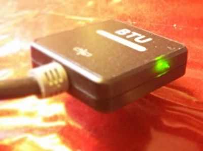
My BTU model is still shining red even after this update to 1.0.1.3. Of course, it remains undetected by my iPad Air or any other Bluetooth 4.0 device I've tried. No joy. Anyone else with success/fail stories? ...regarding the Bluetooth connection especially.Fanti said:Can anyone actually connect to the BTU ? Mine is green but cannot connect to it, it doesn't even show up in the device list.
Please help !
Thanks
Crud, I do distinctly remember that the "Hardware ID" line for the BTU module in the Datalink Assistant software disturbingly went into these weird computer-glitch looking symbols right after the update. Whereas when I updated the ground end TX, the "Hardware ID" line for it just immediately reflected the the new update version, 1.0.1.5, -all very normally. So the update of my BTU module's firmware might have been exhibiting symptoms of an update fail, when its Hardware ID line (where it should have said "1.0.1.3") morphed into unrecognizable shapes after the update. For the record, every instance after that it is successfully recognized as 1.0.1.3 when I test it with the Datalink software. But still, with your BTU showing green, I'm left wondering if I should wait patiently for improved firmware, or get to dealing with a potentially bricked BTU module while I still have warranty time. Very honestly, as far as I know it was a brick when I got it. I have no way of knowing, because it's never been confirmed to be working.
I connected mine yesterday for a bench test. The winds have not been cooperating in Vegas to go do a live flight but I can say that I was able to connect from the app the the BTU and then to my P2. I was able to start the motors and get a good GPS lock an position. I did not upgrade my BT but it worked for me.
ianwood
Taco Wrangler
It's very simple. DJI is being proactive and demonstrating they understand the dangers. They simply made a list of all class B and C airports. Managing rules for each jurisdiction is whole order of magnitude more complicated than one size fits all. If your local AFB is not on it, then it isn't class B or C.
And for those who dislike the no-fly zones altogether, consider that GS is going to introduce a whole new category of mishaps. I can see a whole lot of people buying a Phantom with GS, never touching the remote, plugging in a bunch of waypoints and then hitting GO. Then they'll come onto this forum and write:
" I calibrated the compass. I plugged in the waypoints and sent it off but it never came back. This DJI thing is a piece of junk!"
Yeah, well, your Phantom never came back because it was shredded by a 737 on approach into LAX. Thankfully the plane landed without a flameout and the ground crew were confused by the lack of bird guts in the engine.
Keeping the muppets out of class B and C space is just good common sense. Videos of Phantoms buzzing around KLAS at over 1,000ft are evidence enough.
Thanks, Ed. Guess I need to return this one and try again.Tahoe Ed said:I connected mine yesterday for a bench test. The winds have not been cooperating in Vegas to go do a live flight but I can say that I was able to connect from the app the the BTU and then to my P2. I was able to start the motors and get a good GPS lock an position. I did not upgrade my BT but it worked for me.
killjoy said:No joy. Anyone else with success/fail stories? ...regarding the Bluetooth connection especially. .
My BTU does the same connected to the GS Base, but... if I hook it to the Phantom iOSD mini, it locks green, and I can see the device with my Android, my ipad is in my car... too lazy to grab it right now.
The BTU does not accept any pairing code I try to type in... 0000 or 1234... or a few others I've tried. (
Oh well, just another set back, and a black mark in my faith in DJI.
Similar threads
- Replies
- 0
- Views
- 1K
- Replies
- 3
- Views
- 2K
- Replies
- 0
- Views
- 407
- Replies
- 7
- Views
- 2K
- Replies
- 4
- Views
- 1K


