- Joined
- Nov 1, 2018
- Messages
- 1,247
- Reaction score
- 603
- Age
- 85


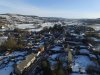
Is there any way of telling the height of the Drone from a picture it took? Took this yesterday but didn't look at the altitude on GO.
In Windows 7 and probably most others, you can right click to bring up the menu, then at the bottom lrft click on properties. This open a new menu with General, Security, Details, Previous versions tabs across the top. Standard file properties in Windoze. Click Details and it will open a Loooong list of the EXIF data for the file which will include the Lat, Lon and Baro Altitude. That altitude is not absolute, but is the height the drone thought it was at, based on the barometric pressure altimeter built in. NOTE: it is in metersIs there any way of telling the height of the Drone from a picture it took? Took this yesterday but didn't look at the altitude on GO.
In Windows 7 and probably most others, you can right click to bring up the menu, then at the bottom lrft click on properties. This open a new menu with General, Security, Details, Previous versions tabs across the top. Standard file properties in Windoze. Click Details and it will open a Loooong list of the EXIF data for the file which will include the Lat, Lon and Baro Altitude. That altitude is not absolute, but is the height the drone thought it was at, based on the barometric pressure altimeter built in. NOTE: it is in meters
Interesting. Mine gives them in feet instead of meters. Perhaps it allocates the measuring system you have set in your DJI Go app?In Windows 7 and probably most others, you can right click to bring up the menu, then at the bottom lrft click on properties. This open a new menu with General, Security, Details, Previous versions tabs across the top. Standard file properties in Windoze. Click Details and it will open a Loooong list of the EXIF data for the file which will include the Lat, Lon and Baro Altitude. That altitude is not absolute, but is the height the drone thought it was at, based on the barometric pressure altimeter built in. NOTE: it is in meters
Interesting. Mine gives them in feet instead of meters. Perhaps it alocates the measuring system you have set in your DJI Go app?
I corrected my previous post. When I started looking at other photos that I knew I was high enough and checked the height, I noticed that they were indeed in meters. From the perspective of the original sample I used to check that out, it didn't look very high.That's strange - I've never seen EXIF data in anything other than metric units.
Let’s have a guessing contest and see who gets the closest?Is there any way of telling the height of the Drone from a picture it took? Took this yesterday but didn't look at the altitude on GO.
Sure, I'll bite. 145 ft, or about 44 m. But...but..when does the contest end? Lets say after we have 10 contestants or this time tomorrow.?Let’s have a guessing contest and see who gets the closest?
180ft. 54 m.
70 metres.Let’s have a guessing contest and see who gets the closest?
180ft. 54 m.
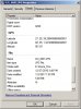
I don't see any mention of altitude in my photo EXIF data or am I not understanding this??
Camera-Specific Properties:
Camera Model: FC300S
Camera Software: Photos 4.0
Maximum Lens Aperture: f/2.0
Focal Length (35mm Equiv): 20 m
Image-Specific Properties:
Horizontal Resolution: 72 dpi
Vertical Resolution: 72 dpi
Image Created: 2019:02:03 11:53:30
Exposure Time: 167/250000 sec
F-Number: f/2.8
Exposure Program: Normal Program
ISO Speed Rating: 100
Lens Aperture: f/2.0
Exposure Bias: 0 EV
Subject Distance: 0.00 m
Metering Mode: Center Weighted Average
Light Source: Unknown
Flash: No Flash Function
Focal Length: 3.61 mm
Color Space Information: Uncalibrated
Image Width: 4000
Image Height: 3000
Exposure Index: 0
Rendering: Normal
Exposure Mode: Auto
White Balance: Auto
Scene Capture Type: Standard
Gain Control: None
Contrast: Normal
Saturation: Normal
Sharpness: Normal
Subject Distance Range: Unknown
Other Properties:
Resolution Unit: i
Exif IFD Pointer: 206
Exif Version: 2.30
Image Generated: 2019:02:03 11:53:30
Image Digitized: 2019:02:03 11:53:30
Meaning of Each Comp: Unknown
Image Compression Mode: 3.3
Shutter Speed: 1/1495 sec
File Source: Other
Scene Type: Unknown
Digital Zoom Ratio: Unused
RATS....without the official Chedder data we will not be able to have a winner.You are only seeing a partial set of EXIF data. You need a better EXIF reader.
") email it to me and I will extract the EXIF for us (so that It matches MY estimate)
email it to me and I will extract the EXIF for us (so that It matches MY estimate)RATS....without the official Chedder data we will not be able to have a winner.