Vision+ Utility Flight Logger Dashware

Re: Vision+ Utility Flight Logger Dashware Demo & help neede

birdheezy said:
Sorry about the crappy quality, not sure what happened. Think i just need to buy dashware... but it's too late tonight to do that now.

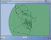
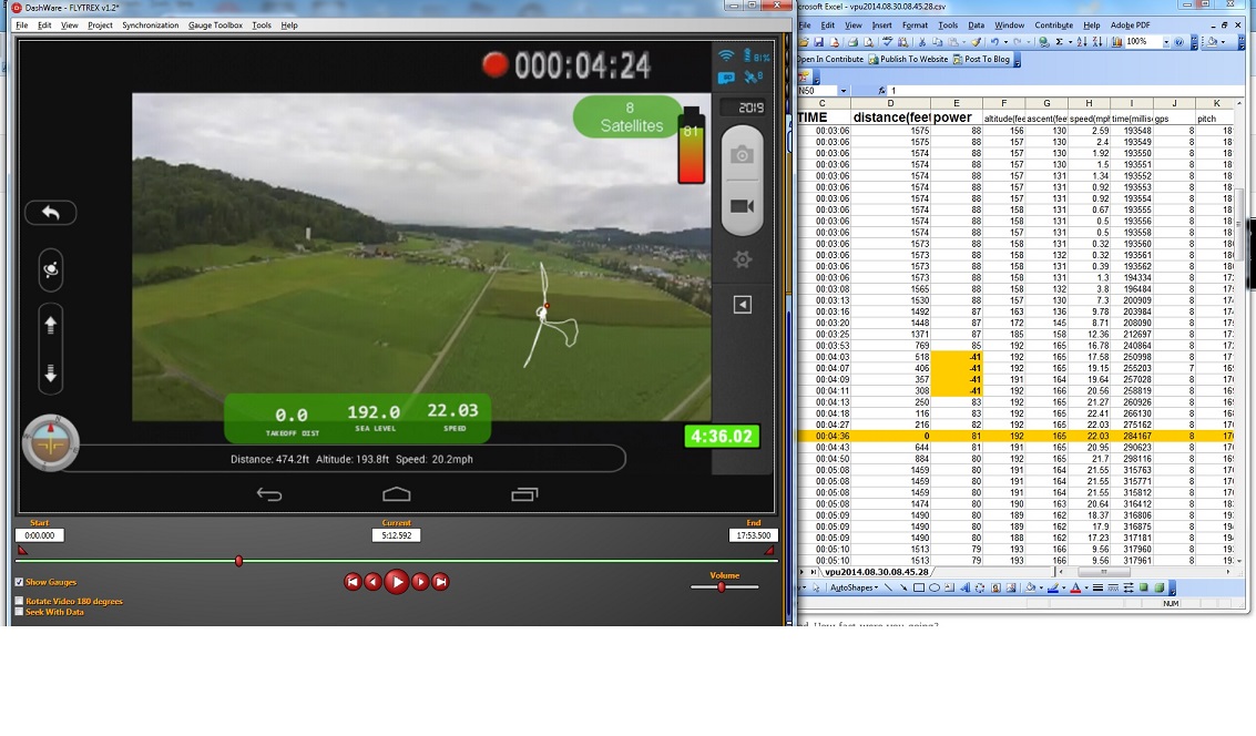
A night fight with the updated Vision+ Utility logger (Version 3.5). Looks like the speeds are good but i'm still having issues with the track. I had more satellites after re-routing the GPS antenna cable, but the track still seems to dispensary for the second half of my flight. not sure if that's a function of dashware or how the coordinates are logged. Sorry for the 6:25 minute video, i'll give you times to jump to for certain things i noticed.

0:00 Stared at 11ft (important for the end)
Think i did a better job of syncing the video and data log
1:05 Started flying forward at full deflection, got an accurate speed reading i think, but at 1:14 the track turns about 15 degrees when i didn't change the position of the stick. It does the same at 1:32 on the way back. i just held the stick all the way forward and all the way back for that portion.
1:50 start a slow 360 rotation for the view (there isn't much at night)
2:21 start the auto go home function just for fun, altitude and distance readouts seem great
3:40 start a fast accent (full deflection) to 375ft
4:44 fly forward at full deflection (speeds looking correct) and no track
Start of no track on mini map
6:20 Fninishing altitude is 37ft when starting altitude was 11ft.

Again sorry for the long video and crappy quality, figured the app guys would wanna see this... and the youtube tags aren't working. too new of a video maybe?

[youtube]http://www.youtube.com/watch?v=adeSADM_AoU[/youtube]

We think it is related to the invalid GPS data logged.

We would like to expain how we decode the telemetry data stream sent from Phantom. Before decoding, we do check if each packet is corrupted or not. Corrupted packet will be ignored and will not be logged. we suspect that invalid data logged is due to GPS gitch that causes the erroneous source GPS data sent from Phantom.

Could you email us the csv file?
 
Re: Vision+ Utility Flight Logger Dashware Demo & help neede

In your app, can you also include the ability for the phone to continuously scan for WiFi if not connected in order for it to re-connect faster once the Phantom is back in range after the WiFi signal is lost for while?
Right now most phones will scan right away when it loses connection, but then will only scan at certain intervals in order to save battery.

-Scott
 
Re: Vision+ Utility Flight Logger Dashware Demo & help neede

I have been busy today working on new gauge options. My favorite is the very bottom center gauge. I also like the Ground Station gauge located top center. I have more to share and may put together another short video to show them in action like I did with this one.

OCATCR, what are the chances of you adding more gauge info in the logger? You should at least be able to add the same info what flytrex uses, couldn't you?


[youtube]http://www.youtube.com/watch?v=O-t48neuKTo[/youtube]
 
Re: Vision+ Utility Flight Logger Dashware Demo & help neede

flyNfrank said:
I have been busy today working on new gauge options. My favorite is the very bottom center gauge. I also like the Ground Station gauge located top center. I have more to share and may put together another short video to show them in action like I did with this one.

OCATCR, what are the chances of you adding more gauge info in the logger? You should at least be able to add the same info what flytrex uses, couldn't you?


[youtube]http://www.youtube.com/watch?v=O-t48neuKTo[/youtube]

Nice vid Frank..nice tune too :)
 
Re: Vision+ Utility Flight Logger Dashware Demo & help neede

Nice. You can measure temperature?
But csv also has sattelite details. You can also make a gauge to include that.
Octatr what is missing is battery level. How come this is not logged in the csv file
 
Re: Vision+ Utility Flight Logger Dashware Demo & help neede

Luap said:
Nice. You can measure temperature?
But csv also has sattelite details. You can also make a gauge to include that.
Octatr what is missing is battery level. How come this is not logged in the csv file

Sorry that the battery level is not logged in iOS version. We will surely add it to the coming release.

We are appreciate all your feedback / suggestion. They do help us keep improving the app. Recently some valuable feedback about our app is posted and we are glad that some phantom buyers keep concerning to make all buyers know our app. We are trying hard to fix the issues/bugs. Eg. someone reported that OPENWRT did not have a stable log file system, so we are rewriting our server program to avoid unnecessary syslog function call. Since all those rewrite takes some times, we are sorry that we need to postpone the release with new features included. We will keep you updated.
 
Re: Vision+ Utility Flight Logger Dashware Demo & help neede

ocatcr, I was investigating some stuff and in doing so I came upon something that has me concerned somewhat. Now I know you are on top of what I'm going to bring up, and because of that is why I'm going to discuss it here and not a email.

While looking through the Logged Data, I noticed one of those weird junk-data lines were included in a flight I had just made. This one happened to appear on a line 529, and instead of two lines like in the past, this was the only one there was.

Strange part this time was when viewing the file on that line, both the longitude & latitude sections displayed "#######" (hash symbol) instead of numbers. But when I copied all the data to show here, when I pasted it on a notepad it displayed this and not the hash symbols "-2.72E+287" and "-4.12E+164".

So here is the actual data from the line 529.

latitude -2.72E+287
longitude -4.12E+164
altitude(feet) 0
ascent(feet) -11
speed(mph) 6019.93
distance(feet) 0
time(millisecond) 593262
gps 9
power 66
pitch -18944
roll 1792
yaw 23553
motor on 0

So what what has me concerned is, as you see on the "motor on" it shows a "0" which would cause a brief shutdown!!! I would think that might cause a issue or two along the way.

What are your thoughts on what I've mentioned here?
 
Re: Vision+ Utility Flight Logger Dashware Demo & help neede

flyNfrank said:
ocatcr, I was investigating some stuff and in doing so I came upon something that has me concerned somewhat. Now I know you are on top of what I'm going to bring up, and because of that is why I'm going to discuss it here and not a email.

While looking through the Logged Data, I noticed one of those weird junk-data lines were included in a flight I had just made. This one happened to appear on a line 529, and instead of two lines like in the past, this was the only one there was.

Strange part this time was when viewing the file on that line, both the longitude & latitude sections displayed "#######" (hash symbol) instead of numbers. But when I copied all the data to show here, when I pasted it on a notepad it displayed this and not the hash symbols "-2.72E+287" and "-4.12E+164".

So here is the actual data from the line 529.

latitude -2.72E+287
longitude -4.12E+164
altitude(feet) 0
ascent(feet) -11
speed(mph) 6019.93
distance(feet) 0
time(millisecond) 593262
gps 9
power 66
pitch -18944
roll 1792
yaw 23553
motor on 0

So what what has me concerned is, as you see on the "motor on" it shows a "0" which would cause a brief shutdown!!! I would think that might cause a issue or two along the way.

What are your thoughts on what I've mentioned here?

We really do not want to say something bad about DJI. But we suspect that those junk data logged is due to GPS gitch that causes the erroneous source GPS data that is sent from Phantom. The possible solution is that tag is added to the log file to indicate which row includes erroneous data. So you could correct the log file before importing it to Dashware. Hopefully we will add it to next release.
 
Re: Vision+ Utility Flight Logger Dashware Demo & help neede

sbarton said:
In your app, can you also include the ability for the phone to continuously scan for WiFi if not connected in order for it to re-connect faster once the Phantom is back in range after the WiFi signal is lost for while?
Right now most phones will scan right away when it loses connection, but then will only scan at certain intervals in order to save battery.

-Scott

It seems that you need to have a rooted device to activate this features.
 
Re: Vision+ Utility Flight Logger Dashware Demo & help neede

flyNfrank said:
ocatcr, I was investigating some stuff and in doing so I came upon something that has me concerned somewhat. Now I know you are on top of what I'm going to bring up, and because of that is why I'm going to discuss it here and not a email.

While looking through the Logged Data, I noticed one of those weird junk-data lines were included in a flight I had just made. This one happened to appear on a line 529, and instead of two lines like in the past, this was the only one there was.

Strange part this time was when viewing the file on that line, both the longitude & latitude sections displayed "#######" (hash symbol) instead of numbers. But when I copied all the data to show here, when I pasted it on a notepad it displayed this and not the hash symbols "-2.72E+287" and "-4.12E+164".

So here is the actual data from the line 529.

latitude -2.72E+287
longitude -4.12E+164
altitude(feet) 0
ascent(feet) -11
speed(mph) 6019.93
distance(feet) 0
time(millisecond) 593262
gps 9
power 66
pitch -18944
roll 1792
yaw 23553
motor on 0

So what what has me concerned is, as you see on the "motor on" it shows a "0" which would cause a brief shutdown!!! I would think that might cause a issue or two along the way.

What are your thoughts on what I've mentioned here?


I believe that is due to column formatting in MS Excel. Try expanding the column and it will most likely show you the same value.


.
 
Re: Vision+ Utility Flight Logger Dashware Demo & help neede

ocatcr said:
sbarton said:
In your app, can you also include the ability for the phone to continuously scan for WiFi if not connected in order for it to re-connect faster once the Phantom is back in range after the WiFi signal is lost for while?
Right now most phones will scan right away when it loses connection, but then will only scan at certain intervals in order to save battery.

-Scott

It seems that you need to have a rooted device to activate this features.

I think that is to permanently change the scan interval. If you look at WiFi Analyzer app, you can change the scan frequency there. It gets reset when you close the app.

-Scott
 
Re: Vision+ Utility Flight Logger Dashware Demo & help neede

ocatar, I seem to now have trouble getting the data in line with dashware. I went through the file and cleaned up any BS entries. Getting the Map display in sync is my only real problem. It kind of seems like the map is running backwards from what it needs to?

I know the map begins to log as soon as the battery is enabled, and then continues right into the point when the motors are enabled.

I opened a older file next to the my last flight for comparison differences, but I was unable to see anything out of spec from each of the two. Mentioning this to you is all I have left with trying to figure out what's wrong.

Next question I have is, What is the purpose of the message box with message about that said to not not shut down the quad. which was after installing the last app update?

Also, in the Logger, what Power is being logged? Is it quad power, or battery power, or?
 
Re: Vision+ Utility Flight Logger Dashware Demo & help neede

flyNfrank said:
ocatar, I seem to now have trouble getting the data in line with dashware. I went through the file and cleaned up any BS entries. Getting the Map display in sync is my only real problem. It kind of seems like the map is running backwards from what it needs to?

I know the map begins to log as soon as the battery is enabled, and then continues right into the point when the motors are enabled.

I opened a older file next to the my last flight for comparison differences, but I was unable to see anything out of spec from each of the two. Mentioning this to you is all I have left with trying to figure out what's wrong.

Next question I have is, What is the purpose of the message box with message about that said to not not shut down the quad. which was after installing the last app update?

Also, in the Logger, what Power is being logged? Is it quad power, or battery power, or?

1. Refer to Dashware manual. To synchronize, locate a spot in the video that corresponds to a spot in the data. The slider below the video moves through video time, the slider in the Synchronization tab moves through the data time. I find the easiest is to look for where you first start moving in the video. Then locate where the speed first starts going up in the data. Click the “Sync with video” checkbox in the Sync tab to sync them together. Playback your video. If the data looks a little off, uncheck “Sync with video”, adjust, and then recheck “Sync with video”. You can make fine adjustments with the < and > buttons on either side of the play button (below video or in sync tab). By default they move by 0.1 seconds. Holding Alt makes them move by 1 second.

2. The message box with message about that said to not not shut down the quad tell you that the server program is being upgraded.

3. the logged battery is the quad battery level that is same as the level shown in the DJI Vision app.
 
Re: Vision+ Utility Flight Logger Dashware Demo & help neede

ocatcr said:
flyNfrank said:
ocatar, I seem to now have trouble getting the data in line with dashware. I went through the file and cleaned up any BS entries. Getting the Map display in sync is my only real problem. It kind of seems like the map is running backwards from what it needs to?

I know the map begins to log as soon as the battery is enabled, and then continues right into the point when the motors are enabled.

I opened a older file next to the my last flight for comparison differences, but I was unable to see anything out of spec from each of the two. Mentioning this to you is all I have left with trying to figure out what's wrong.

Next question I have is, What is the purpose of the message box with message about that said to not not shut down the quad. which was after installing the last app update?

Also, in the Logger, what Power is being logged? Is it quad power, or battery power, or?

1. Refer to Dashware manual. To synchronize, locate a spot in the video that corresponds to a spot in the data. The slider below the video moves through video time, the slider in the Synchronization tab moves through the data time. I find the easiest is to look for where you first start moving in the video. Then locate where the speed first starts going up in the data. Click the “Sync with video” checkbox in the Sync tab to sync them together. Playback your video. If the data looks a little off, uncheck “Sync with video”, adjust, and then recheck “Sync with video”. You can make fine adjustments with the < and > buttons on either side of the play button (below video or in sync tab). By default they move by 0.1 seconds. Holding Alt makes them move by 1 second.

2. The message box with message about that said to not not shut down the quad tell you that the server program is being upgraded.

3. the logged battery is the quad battery level that is same as the level shown in the DJI Vision app.

I have a feeling you haven't used dashware software to see if your app is still functioning ok or not, lately. I'm not flaming on you, and I don't mean for it to appear like I am if it seems that away to you. Today I have tried to point out to you that the mapping part of the syncing process has changed.

If I launch my quad and fly straight up and level off at 770ft, and then descend straight down and land, then power off the quad. What would you expect my map data to look like? Should it resemble a flag pole, or a birds nest?

Before starting the motors, the logger records all activity once it has power to do so. The issue seen is what I have heard referred to as "gps drift". I know nothing about it other then the name I mentioned. It does this with flytrex all the same. But, there is useable data along with a mapping display that resembles the flight. Flytrex core2 with display the birds nest and the flag pole in a straight up & down flight.

I have only checked a couple of the current features you have set to log. One is ok where the other is off. I found the alitude to current be off by 60ft when I checked earlier in the night.

At this point I'm hoping between you and your crew, one of you may know what is needed to cure this issue.
 

Attachments

  • DW1.jpg
    DW1.jpg
    64.2 KB · Views: 478
Re: Vision+ Utility Flight Logger Dashware Demo & help neede

flyNfrank said:
I have a feeling you haven't used dashware software to see if your app is still functioning ok or not, lately. I'm not flaming on you, and I don't mean for it to appear like I am if it seems that away to you. Today I have tried to point out to you that the mapping part of the syncing process has changed.

If I launch my quad and fly straight up and level off at 770ft, and then descend straight down and land, then power off the quad. What would you expect my map data to look like? Should it resemble a flag pole, or a birds nest?

Before starting the motors, the logger records all activity once it has power to do so. The issue seen is what I have heard referred to as "gps drift". I know nothing about it other then the name I mentioned. It does this with flytrex all the same. But, there is useable data along with a mapping display that resembles the flight. Flytrex core2 with display the birds nest and the flag pole in a straight up & down flight.

I have only checked a couple of the current features you have set to log. One is ok where the other is off. I found the alitude to current be off by 60ft when I checked earlier in the night.

At this point I'm hoping between you and your crew, one of you may know what is needed to cure this issue.

Could you email us the original csv file and send us more detail about the issues you found (eg. tell us which portion of the csv file has problem)? Also, you could only focus on the rows that has a '1' in "motor on" column. where "motor on" column indicates the motor is spinning or not.
 
Re: Vision+ Utility Flight Logger Dashware Demo & help neede

First a big thanks to Ocatcr for fixing the speed bug and adding power(battery) - pitch - roll and yaw values in the CSV.
Is there any video camera on/off data?

I havn't had any drifting issues per above post but I am experiencing some incorrect data logged in the csv.

I compare the data from video capture of the DJI Vision app with overlayed gauges in DashWare from CSV file.

A picture below whith a clear logging error.
at 4:36:02 in green you will note in the excel table a distance of 0 feet. In the video capture distance is 474.2ft.

Between 4:03 andf 4:11 in the excel table you will note -41 power (battery level)
In the video capture its changing from 84 to 83.

If the DJI app is capturing data from same source as the capture program, surely both would show same error?
So can this be fixed in the logger app?
incorrect%20values1.jpg
 
Re: Vision+ Utility Flight Logger Dashware Demo & help neede

Luap said:
First a big thanks to Ocatcr for fixing the speed bug and adding power(battery) - pitch - roll and yaw values in the CSV.
Is there any video camera on/off data?

I havn't had any drifting issues per above post but I am experiencing some incorrect data logged in the csv.

I compare the data from video capture of the DJI Vision app with overlayed gauges in DashWare from CSV file.

A picture below whith a clear logging error.
at 4:36:02 in green you will note in the excel table a distance of 0 feet. In the video capture distance is 474.2ft.

Between 4:03 andf 4:11 in the excel table you will note -41 power (battery level)
In the video capture its changing from 84 to 83.

If the DJI app is capturing data from same source as the capture program, surely both would show same error?
So can this be fixed in the logger app?
incorrect%20values1.jpg

we think that those junk data logged is due to some gitches that causes the erroneous source data that is sent from Phantom. The possible solution is that a column is added to the log file to indicate which row includes erroneous data. So you could correct the log file before importing it to Dashware. Hopefully we will add it to next release.
 
Re: Vision+ Utility Flight Logger Dashware Demo & help neede

ocatcr said:
we think that those junk data logged is due to some gitches that causes the erroneous source data that is sent from Phantom. The possible solution is that a column is added to the log file to indicate which row includes erroneous data. So you could correct the log file before importing it to Dashware. Hopefully we will add it to next release.
If I can just comment on this. First, I have your app and really like it. I love being able to imbed telemetry in my videos. Second, I have had some of those glitches and they can be very difficult to find. Wouldn't be so bad if they didn't cause problems in Dashware - but they do. So I'm really glad that there seems to be something you can do about it. I would of course rather DJI fix their data, if that is where the problem is. Always better than a post-processing work around.

But:
It makes me very uncomfortable that any extra processing is going on onboard the Phantom. Don't like the idea of stealing cycles from the flight control processor(s). When I first got this app I was under the impression that the only processing happening on the Phantom side was to hook a data port, where there was already telemetry data being provided, to funnel it to your logging app on the phone. While I was not real comfortable with that, I do understand there has to be something on the Phantom side for your app if you are not able to capture it on the phone side.

I don't even know if you are able to install additional firmware on the Phantom. And I do think it's a good thing to clean up the data or at least mark rows that may be invalid to ease the Dashware experience, but my hope would be that in your design you would confine processing where possible to the phone side of things and leave as much processing power as possible on the Phantom side for flight control.

And I do hope my concerns are baseless! :)
 
Re: Vision+ Utility Flight Logger Dashware Demo & help neede

OCATCR, is there a list of possible stuff we can have logged data to? In other words, is there anything else we can add to what we already have?

Also, I sent you a file to your email, did you receive it?
 
Re: Vision+ Utility Flight Logger Dashware Demo & help neede

mmn said:
ocatcr said:
we think that those junk data logged is due to some gitches that causes the erroneous source data that is sent from Phantom. The possible solution is that a column is added to the log file to indicate which row includes erroneous data. So you could correct the log file before importing it to Dashware. Hopefully we will add it to next release.
If I can just comment on this. First, I have your app and really like it. I love being able to imbed telemetry in my videos. Second, I have had some of those glitches and they can be very difficult to find. Wouldn't be so bad if they didn't cause problems in Dashware - but they do. So I'm really glad that there seems to be something you can do about it. I would of course rather DJI fix their data, if that is where the problem is. Always better than a post-processing work around.

But:
It makes me very uncomfortable that any extra processing is going on onboard the Phantom. Don't like the idea of stealing cycles from the flight control processor(s). When I first got this app I was under the impression that the only processing happening on the Phantom side was to hook a data port, where there was already telemetry data being provided, to funnel it to your logging app on the phone. While I was not real comfortable with that, I do understand there has to be something on the Phantom side for your app if you are not able to capture it on the phone side.

I don't even know if you are able to install additional firmware on the Phantom. And I do think it's a good thing to clean up the data or at least mark rows that may be invalid to ease the Dashware experience, but my hope would be that in your design you would confine processing where possible to the phone side of things and leave as much processing power as possible on the Phantom side for flight control.

And I do hope my concerns are baseless! :)

Thanks for your feedback. We think there is misunderstanding on the server program running on Phantom. The server program is running on the AP that OPENWRT is installed. AP and the flight controller are two separated thing. The server program has nothing to do on the flight controller. It is a program monitors the data sent from the flight controller. We are sure that your concern that "stealing cycles from the flight control processor(s)" is not true. And there is no impact on the flight controller operation. So dont worry about that and be comfortable.
 

Recent Posts

Members online

No members online now.

Forum statistics

Threads
143,102
Messages
1,467,659
Members
104,991
Latest member
tpren3