
Edit....found the hiccup...apparently you have to right click on the middle file in google earth and choose show elevation profile...if I click on the top kml file I get data that is messed up. octar...I am having an issue with the kml files not containing or not showing any data other than the flight plath. I am using a nexus 7 to run the logger and it logs info and creates the 3 files. The first time I opened the original kml on my laptop it showed the filght data such as distance and altitude. Ever since the first attempt I am getting nothing out the kml files using google earth. I have attempted it on several machines so I do not think it is google earth. Can you please look at it and let me know whats going on? If anyone else wants to look at it feel free. I am open to suggestions...already tried the reboot the nexus trick.


You are using an out of date browser. It may not display this or other websites correctly.
You should upgrade or use an alternative browser.
You should upgrade or use an alternative browser.
Vision+ Utility Flight Logger Dashware
- Thread starter ocatcr
- Start date
Absolutely last question!!
When I change the dbm settings for camera/Range extend I get no better dbm readouts from my monitoring program on my phone.
i.e if I set both to 0dbm or 20dbm I get the same dbm output reading from the monitoring... I am trying from atleast 30 M (not right next to each other as that would get max anyways lol)
I would of expected 20dbm would get a better reading than 0dbm... I know the wireless monitoring app definetly works as I used to play around alot with it, with my 2.4ghz amplifier that I use to extend the range of my house Access Point..
Read the instructions a number of times, click 'connect vision+" and just change the dbm setting right, there is no ok/save button to click on or anything like that, right ?
As I said.. wont ask anymore dumb questions.. in this thread
Thanks again so much I'm sure its working, just I like to see data to confirm.
When I change the dbm settings for camera/Range extend I get no better dbm readouts from my monitoring program on my phone.
i.e if I set both to 0dbm or 20dbm I get the same dbm output reading from the monitoring... I am trying from atleast 30 M (not right next to each other as that would get max anyways lol)
I would of expected 20dbm would get a better reading than 0dbm... I know the wireless monitoring app definetly works as I used to play around alot with it, with my 2.4ghz amplifier that I use to extend the range of my house Access Point..
Read the instructions a number of times, click 'connect vision+" and just change the dbm setting right, there is no ok/save button to click on or anything like that, right ?
As I said.. wont ask anymore dumb questions.. in this thread
Thanks again so much
I'm sure its working, just I like to see data to confirm.juangelb said:Fabiog said:Hi, I present the problem encountered in the use of the application. I made all the steps involved and when I went to close the Vision + Utility I have already found it disconnected. During the flight, I simply stopped recording the video and then I started again. The application has, however, produced the 3 files that I send to Ocatcr by email ([email protected]: I hope it's the right one!)
Csv and kml files are unusable. I also activated the command "Export all" but to no avail.
I ask Ocatcr to try to utilize the raw file to extrapolate kml and csv files readable. Thanks!
Fabiog,
Why are you saying that Csv And kml are unusable ?
No data at all in it ?
Best regards : Juan
Sure, juangelg, they had no data. I sent raw file to [email protected] wich exported kml amd csv file with right data. I'll show the result in Google Earth in another post, answering to ocatcr.
By, Fabio
- Joined
- Feb 27, 2014
- Messages
- 448
- Reaction score
- 24
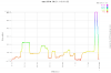
lsteigerwalt said:Edit....found the hiccup...apparently you have to right click on the middle file in google earth and choose show elevation profile...if I click on the top kml file I get data that is messed up. octar...I am having an issue with the kml files not containing or not showing any data other than the flight plath. I am using a nexus 7 to run the logger and it logs info and creates the 3 files. The first time I opened the original kml on my laptop it showed the filght data such as distance and altitude. Ever since the first attempt I am getting nothing out the kml files using google earth. I have attempted it on several machines so I do not think it is google earth. Can you please look at it and let me know whats going on? If anyone else wants to look at it feel free. I am open to suggestions...already tried the reboot the nexus trick.
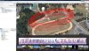
attached are google earth shows. we are using Google Earth windows version 7.1.2.2041
Attachments
- Joined
- Feb 27, 2014
- Messages
- 448
- Reaction score
- 24
justin00 said:Absolutely last question!!
When I change the dbm settings for camera/Range extend I get no better dbm readouts from my monitoring program on my phone.
i.e if I set both to 0dbm or 20dbm I get the same dbm output reading from the monitoring... I am trying from atleast 30 M (not right next to each other as that would get max anyways lol)
I would of expected 20dbm would get a better reading than 0dbm... I know the wireless monitoring app definetly works as I used to play around alot with it, with my 2.4ghz amplifier that I use to extend the range of my house Access Point..
Read the instructions a number of times, click 'connect vision+" and just change the dbm setting right, there is no ok/save button to click on or anything like that, right ?
As I said.. wont ask anymore dumb questions.. in this thread
Thanks again so much
Are you testing our app on Phantom Vision? our app is only compatible with Vision Plus.
ocatcr said:Fabiog said:Hi, I present the problem encountered in the use of the application. I made all the steps involved and when I went to close the Vision + Utility I have already found it disconnected. During the flight, I simply stopped recording the video and then I started again. The application has, however, produced the 3 files that I send to Ocatcr by email ([email protected]: I hope it's the right one!)
Csv and kml files are unusable. I also activated the command "Export all" but to no avail.
I ask Ocatcr to try to utilize the raw file to extrapolate kml and csv files readable. Thanks!
It is weird. Could you email us the raw file?
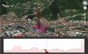
I sent the raw file to [email protected] and he was able to export csv and kml file.
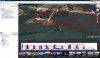
With the kml file I could view flight data in Google Earth (see attachment).
Attachments
Fabiog said:juangelb said:Fabiog said:Hi, I present the problem encountered in the use of the application. I made all the steps involved and when I went to close the Vision + Utility I have already found it disconnected. During the flight, I simply stopped recording the video and then I started again. The application has, however, produced the 3 files that I send to Ocatcr by email ([email protected]: I hope it's the right one!)
Csv and kml files are unusable. I also activated the command "Export all" but to no avail.
I ask Ocatcr to try to utilize the raw file to extrapolate kml and csv files readable. Thanks!
Fabiog,
Why are you saying that Csv And kml are unusable ?
No data at all in it ?
Best regards : Juan
Sure, juangelg, they had no data. I sent raw file to [email protected] wich exported kml amd csv file with right data. I'll show the result in Google Earth in another post, answering to ocatcr.
By, Fabio
Fabiog,
I had this kinda issue with app... indoors almost always i got the CSV file.... outdoors never ever.
I undestand that the issue was due to the decimal symbor in Brazil being "," and not "." and the app in trying to write csv file... with two more "," ....
Indoor worked because as had not satellites ... no position data ... not additional "," at all...
Solved changing Galaxy S4 to english language ! From that all worked fine !
Best regards : Juan
If I understand your question, you use the CSV file from the logger and the Flytrex profile in DashWare. You can customize that profile and save it under a different name if you want to get creative. And I think others on here have produced a modified profile and built some custom gauges.justin00 said:Me again.. I do intend to read the 35 pages here for any tips/tricks and I know this thread isn't related to dashware... but just installed dashware it and having a quick look...
What data input type would I select ? and I imagine I will need to play around with the mapping to create columns that match the CSV ? like I create a custom data input type ?
Which data type would I select / is the closest to what this utility app provides ?
thanks again
And you are right, this thread isn't for how to use and abuse DashWare.
juangelb said:Fabiog,
I had this kinda issue with app... indoors almost always i got the CSV file.... outdoors never ever.
I undestand that the issue was due to the decimal symbor in Brazil being "," and not "." and the app in trying to write csv file... with two more "," ....
Indoor worked because as had not satellites ... no position data ... not additional "," at all...
Solved changing Galaxy S4 to english language ! From that all worked fine !
Best regards : Juan
Juan,
I'm Italian! Then it's a problem of latin languages?
I work with Samsung Galaxy Note 3: I'll try your solution! Waiting for a bug fixing (ocatcr!) ....
Thank you very much
Fabio
Fabiog said:juangelb said:Fabiog,
I had this kinda issue with app... indoors almost always i got the CSV file.... outdoors never ever.
I undestand that the issue was due to the decimal symbor in Brazil being "," and not "." and the app in trying to write csv file... with two more "," ....
Indoor worked because as had not satellites ... no position data ... not additional "," at all...
Solved changing Galaxy S4 to english language ! From that all worked fine !
Best regards : Juan
Juan,
I'm Italian! Then it's a problem of latin languages?
I work with Samsung Galaxy Note 3: I'll try your solution! Waiting for a bug fixing (ocatcr!) ....
Thank you very much
Fabio
Fabiog,
In my understanding there is an issue with languages thar use "," as decimal symbol.
So in changing the language from Portuguese Brazil to English US and therefor changed from "," to "." decimal symbol.... all worked fine.
Best regards : Juan
Yeah I have a PV2+
I'll do actual video tests fro the phantom and confirm it increases range and works, I suspect it will.
I was just testing using a wireless analyzer for android.
But just to confirm I am using the tool correctly..... Once I "connect to vision" I can select for e.g 10dbm, then change to 15dbm then change to 5dbm if I wanted..
and I don't need to click save or anything... I just change from the dropdown and it will change in real time, right ?
And thanks for info regarding dashware MMN, What you said was exactly what I was after. I shall not bring it up again
I'll do actual video tests fro the phantom and confirm it increases range and works, I suspect it will
. I was just testing using a wireless analyzer for android.
But just to confirm I am using the tool correctly..... Once I "connect to vision" I can select for e.g 10dbm, then change to 15dbm then change to 5dbm if I wanted..
and I don't need to click save or anything... I just change from the dropdown and it will change in real time, right ?
And thanks for info regarding dashware MMN, What you said was exactly what I was after. I shall not bring it up again
ocatcr said:justin00 said:Absolutely last question!!
When I change the dbm settings for camera/Range extend I get no better dbm readouts from my monitoring program on my phone.
i.e if I set both to 0dbm or 20dbm I get the same dbm output reading from the monitoring... I am trying from atleast 30 M (not right next to each other as that would get max anyways lol)
I would of expected 20dbm would get a better reading than 0dbm... I know the wireless monitoring app definetly works as I used to play around alot with it, with my 2.4ghz amplifier that I use to extend the range of my house Access Point..
Read the instructions a number of times, click 'connect vision+" and just change the dbm setting right, there is no ok/save button to click on or anything like that, right ?
As I said.. wont ask anymore dumb questions.. in this thread
Thanks again so much
Are you testing our app on Phantom Vision? our app is only compatible with Vision Plus.
Hi,
using the trick suggested from juangelb (switching my device language from Italian to English) I was able to use the "export all" command and save "old" kml files.
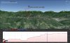
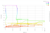
Very good the result but with an error about altitudes: during the flight I reached 185 meters as maximum altitude; using Google Earth "Show elevation profile" function show max altitude 622 m.
????? :shock:
Error is about all the points, not only the max level .....
By, Fabio
using the trick suggested from juangelb (switching my device language from Italian to English) I was able to use the "export all" command and save "old" kml files.
Very good the result but with an error about altitudes: during the flight I reached 185 meters as maximum altitude; using Google Earth "Show elevation profile" function show max altitude 622 m.
????? :shock:
Error is about all the points, not only the max level .....
By, Fabio
Attachments
Fabiog said:Hi,
using the trick suggested from juangelb (switching my device language from Italian to English) I was able to use the "export all" command and save "old" kml files.
Very good the result but with an error about altitudes: during the flight I reached 185 meters as maximum altitude; using Google Earth "Show elevation profile" function show max altitude 622 m.
????? :shock:
Error is about all the points, not only the max level .....
By, Fabio
I understood the problem:
both Google Earth and GPSVisualizer read kml altitude data as meters instead feet, without doing the conversion;
instead if you draw the track profile using csv file (setting meters) altitude is correct;
if you convert csv to kml and then open the kml file with Google Earth, altitude is correct!
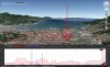
Attachments
Hi flyNfrank,flyNfrank said:So is everyone getting use to the app now, or is someone still not understanding something?
All understood... but it would be nice to get an updated version aware of decimal mark or decimal symbol android is using, avoiding in this way headaches to users like FabioG.
My personnal experience on this app was bad since i stayed for almost 30 days trying to do it working.
No help from developer at all, only telling me "weird" ... "weird" .... and "try it on another device.."
I stayed getting crazy on this.... trying to realize what was going on and why the app did not worked for me.... (my first days on android)
Till i changed language to english... suspecting it had to do with the issue, and all worked fine from this on.
Out of this, application is wonderful and has all i need. Congratulations to developer.
Best regards : Juan
flyNfrank said:So is everyone getting use to the app now, or is someone still not understanding something?
I quote juangelb! Another problem to solve is about altitudes, as I posted ...: kml file read imperial units as metric!
As I shown I had to convert csv file to kml and then import in Google Earth ....
This is an .... "imperial app"!!!
juangelb said:Hi flyNfrank,flyNfrank said:So is everyone getting use to the app now, or is someone still not understanding something?
All understood... but it would be nice to get an updated version aware of decimal mark or decimal symbol android is using, avoiding in this way headaches to users like FabioG.
My personnal experience on this app was bad since i stayed for almost 30 days trying to do it working.
No help from developer at all, only telling me "weird" ... "weird" .... and "try it on another device.."
I stayed getting crazy on this.... trying to realize what was going on and why the app did not worked for me.... (my first days on android)
Till i changed language to english... suspecting it had to do with the issue, and all worked fine from this on.
Out of this, application is wonderful and has all i need. Congratulations to developer.
Best regards : Juan
I'm glad to hear you are finally reaching a point that you are getting more comfortable with it. I know the developer has came leap & bounds from when I 1st got involved with his app.
- Joined
- Feb 27, 2014
- Messages
- 448
- Reaction score
- 24
kxkraze said:Is the iOS version ever going to get the kml file and other updates?
yes. kml log file output will be in the coming update.
- Joined
- Feb 27, 2014
- Messages
- 448
- Reaction score
- 24
juangelb said:Fabiog said:juangelb said:Fabiog,
I had this kinda issue with app... indoors almost always i got the CSV file.... outdoors never ever.
I undestand that the issue was due to the decimal symbor in Brazil being "," and not "." and the app in trying to write csv file... with two more "," ....
Indoor worked because as had not satellites ... no position data ... not additional "," at all...
Solved changing Galaxy S4 to english language ! From that all worked fine !
Best regards : Juan
Juan,
I'm Italian! Then it's a problem of latin languages?
I work with Samsung Galaxy Note 3: I'll try your solution! Waiting for a bug fixing (ocatcr!) ....
Thank you very much
Fabio
Fabiog,
In my understanding there is an issue with languages thar use "," as decimal symbol.
So in changing the language from Portuguese Brazil to English US and therefor changed from "," to "." decimal symbol.... all worked fine.
Best regards : Juan
Thanks for all your support and feedback. We will fix it in the next release.
Similar threads
- Replies
- 1
- Views
- 2K
- Replies
- 9
- Views
- 1K
- Replies
- 14
- Views
- 2K
- Replies
- 28
- Views
- 4K


