Link to flight info:
HealthyDrones.com - Innovative flight data analysis that matters
I was flying backwards getting footage of land, when djigo crashed (nothing new); I immediately hit RTH, then worked on getting djigo back open (which previously worked - was usually able to reconnect without landing). However, the aircraft did not RTH, djigo never reconnected, and the RC never reconnected. I’m hoping someone can take a look and offer some advice on where to look.
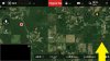
I’m also attaching a pic that may or may not be useful. A day or two after losing my P4, I connected my RC to my phone; no camera view of course, but I clicked on lower-left box (map), then clicked dot and selected aircraft location, not expecting it to show anything. HOWEVER, it showed its location as being a mile or so from me – at a location I’ve never flown over. After looking at the map of my flight, its trajectory would’ve put the aircraft around this spot. In the attached pic, the yellow arrow on the right points to the last known location of aircraft (seen on healthydrones.com); the red dot on the left is what djigo was showing as aircraft’s location a day or two after losing P4. Useful info, or just a coincidence it showed the disconnected aircraft’s location at a location I’ve never been or flown over?
Finally, not sure if relevant, but when I visited the last-known GPS coordinates of aircraft, my phone lost all GPS satellites, until I was out from under last known GPS signal – a definite GPS dead zone. But I don’t THINK it explains losing communication with RC. I wish I knew what happened when an aircraft loses communication with RC in a GPS dead zone – does it stop & hover til the battery dies, then land (wherever it is, vs finding a spot free of obstacles); or does it just keep flying along the path I had it; or something else?
Thanks in advance for any and all advice you can offer on where to look or what other steps to take. The area under last-known location is thick with briars & brush – it took me 5 hours to get from the home location on the right to the end of the yellow line. I originally planned to continue along this flight trajectory, but if anybody has a better idea, I would very much appreciate it.
HealthyDrones.com - Innovative flight data analysis that matters
I was flying backwards getting footage of land, when djigo crashed (nothing new); I immediately hit RTH, then worked on getting djigo back open (which previously worked - was usually able to reconnect without landing). However, the aircraft did not RTH, djigo never reconnected, and the RC never reconnected. I’m hoping someone can take a look and offer some advice on where to look.
I’m also attaching a pic that may or may not be useful. A day or two after losing my P4, I connected my RC to my phone; no camera view of course, but I clicked on lower-left box (map), then clicked dot and selected aircraft location, not expecting it to show anything. HOWEVER, it showed its location as being a mile or so from me – at a location I’ve never flown over. After looking at the map of my flight, its trajectory would’ve put the aircraft around this spot. In the attached pic, the yellow arrow on the right points to the last known location of aircraft (seen on healthydrones.com); the red dot on the left is what djigo was showing as aircraft’s location a day or two after losing P4. Useful info, or just a coincidence it showed the disconnected aircraft’s location at a location I’ve never been or flown over?
Finally, not sure if relevant, but when I visited the last-known GPS coordinates of aircraft, my phone lost all GPS satellites, until I was out from under last known GPS signal – a definite GPS dead zone. But I don’t THINK it explains losing communication with RC. I wish I knew what happened when an aircraft loses communication with RC in a GPS dead zone – does it stop & hover til the battery dies, then land (wherever it is, vs finding a spot free of obstacles); or does it just keep flying along the path I had it; or something else?
Thanks in advance for any and all advice you can offer on where to look or what other steps to take. The area under last-known location is thick with briars & brush – it took me 5 hours to get from the home location on the right to the end of the yellow line. I originally planned to continue along this flight trajectory, but if anybody has a better idea, I would very much appreciate it.