Phantom 4 fell out of the sky...why?

Sure you can get everything I looked at using DATCON and CSVVIEW: CsvView/DatCon


Thanks, grabbed both. Converted the .DAT file and have been having fun looking at the data. It is pretty obvious something went wrong, but what exactly is not clear.

Plotting the power draw vs gpsAlt and a couple other factors you can clearly see the GPS was reflecting real world actions (with normal GPS response issues), power draw increasing on climb and decreasing on fall. So the GPS and the power draw both indicate the barometer data was lagging badly. Since the P4 was (probably) reacting to the barometer to hold altitude the responses of the aircraft lagged the real world badly. And down it came.

Why it happened I don't know, but I will be keeping a closer eye on things, including looking at data post flight, for a while to come until I can determine there is not a system problem.

T!
 
  • Like
Reactions: BudWalker
Glad you got it figured out. If it happens again I'd send it back to DJI for sure as something is definitely off with the barometer.

you can thank @BudWalker for creating the datfile programs. :)
 
  • Like
Reactions: macoman
Ok so after digging into your logs, It does appear as though the craft developed a mind of its own for one reason or another in terms of the altitude. The barometer height and GPS height seemed to skew around the 100 second mark. It also seems as though the drone realized this as this was in the log:
106.061 : 846153654 : 9009 [L-FDI][FDI][CTRL]: fault on , height_ctrl_fail

That said, there was definitely some kind of issue that occurred with the barometer and height control of the craft. I don't know if it was caused by the environment or hardware. You could either send it back to DJI for diagnostic/warranty, or you could wait and see if it happens again.


View attachment 74416
View attachment 74417

Cool charts. I see where the GPS and barometer heights differed in the light green and blue lines. They only seem to agree at 20 seconds if time is at the bottom of the chart. Around 70 to 80 seconds later they really began to differ. I suspect the barometer is warming up perhaps but dunno. Some thermal electronic issue seems to be at play here. Maybe too much redundancy is making a mess out of the entire system. My P4 under belly sensors never report my landing spot as the same as the take-off by several meters. Really is a poor system for any height distances in my opinion.
 
Cool charts. I see where the GPS and barometer heights differed in the light green and blue lines. They only seem to agree at 20 seconds if time is at the bottom of the chart. Around 70 to 80 seconds later they really began to differ. I suspect the barometer is warming up perhaps but dunno. Some thermal electronic issue seems to be at play here. Maybe too much redundancy is making a mess out of the entire system. My P4 under belly sensors never report my landing spot as the same as the take-off by several meters. Really is a poor system for any height distances in my opinion.
Not sure I follow why you think it's a poor system? Below 30 feet the drone uses the ultrasonic sensors to maintain height, above that it uses the barometer. GPS is never used for height, even though it records GPS height in the logs. In this case, the barometer reported the drone was doing something that the IMU disagreed was happening, thus the altitude issue.
 
Not sure I follow why you think it's a poor system? Below 30 feet the drone uses the ultrasonic sensors to maintain height, above that it uses the barometer. GPS is never used for height, even though it records GPS height in the logs. In this case, the barometer reported the drone was doing something that the IMU disagreed was happening, thus the altitude issue.

Poor because my cheap $20 Harbor Freight electronic tape measure that also uses sonar measures more accurately - and in mm/inches - than my P4 does on distance pointing them both down and constantly. This guy Ultrasonic Distance Meter with Laser Pointer The P4 should be as accurate when compared to that $20 device, but mine sure isn't no matter how many calibrations I do to it (Where the $20 thing needs none!).

Poor too in that is there are 4 systems for redundancy of altitude: GPS, barometer, sonar, and the VPS camera. With that much gear, take-off at zero feet should result in a landing at same spot with zero feet too, and not GO showing landing as -10 meters after 25 minutes in the air. Ridiculously poor measuring system for that much redundancy as backup, imho. Even an adequately designed system with poor Q.C. and with that much redundancy should be no more than a meter at most.

I suspect DJI also uses the GPS data in flight in conjunction with other sensors, otherwise why include the data stream for analysis? Seems like some wives tale that is getting passed on without any input as to what and how the system really operates, albeit poorly at times.
 
Last edited:
Poor because my cheap $20 Harbor Freight electronic tape measure that also uses sonar measures more accurately - and in mm/inches - than my P4 does on distance pointing them both down and constantly. This guy Ultrasonic Distance Meter with Laser Pointer The P4 should be as accurate when compared to that $20 device, but mine sure isn't no matter how many calibrations I do to it (Where the $20 thing needs none!).

Poor too in that is there are 4 systems for redundancy of altitude: GPS, barometer, sonar, and the VPS camera. With that much gear, take-off at zero feet should result in a landing at same spot with zero feet too, and not GO showing landing as -10 meters after 25 minutes in the air. Ridiculously poor measuring system for that much redundancy as backup, imho. Even an adequately designed system with poor Q.C. and with that much redundancy should be no more than a meter at most.

I suspect DJI also uses the GPS data in flight in conjunction with other sensors, otherwise why include the data stream for analysis? Seems like some wives tale that is getting passed on without any input as to what and how the system really operates, albeit poorly at times.
The altitude in GO is the barometer, which is generally off by the time you land. GPS altitude has a margin of error of several meters, which is why it's not used. But it's recorded so that it can give a general comparison if for example the barometer fails. The VPS camera is not used for altitude. I think you have some misunderstandings as to how these systems work.
 
Poor because my cheap $20 Harbor Freight electronic tape measure that also uses sonar measures more accurately - and in inches - than my P4 does on distance pointing them both down and constantly. This guy Ultrasonic Distance Meter with Laser Pointer The P4 should be as accurate when compared to that $20 device, but mine sure isn't no matter how many calibrations I do to it (Where the $20 thing needs none!).

The difference is that you can point the electronic tape measure at exactly what you want to measure, and it even has a laser pointer built in so you can confirm it is pointed at the right thing. In order to measure ONLY the distance to the point you are interested the ultrasonics of that unit probably have a significantly narrower field of view than those found on the P4. If that is true such a reduced beamwidth system on the Phantom would have to continually position the sensor to be pointed straight down, otherwise in turns, with roll input, or in wind, the quad would be looking at the ground further away than right below it, and constantly be driving down under those conditions.

The amount of altitude error would depend on the bank / pitch angle, bigger angles would equal a longer hypotenuse. The addition of a positioning system to keep the narrower FOV pointed at the ground would drive cost up, and add one more moving system to potentially fail.

Think of it this way, when you point your tape measure at a target 15 degrees off of your intended measurement point, do you still get an accurate reading to the point you want to measure? The quad can easily have more than 15 deg of pitch / bank, and it still needs to measure the distance to the ground directly below it.

With a wider field of view system the attitude (bank / pitch angle) of the quad is less likely to change any altitude over ground value. But a wider field of view means less gain. I have no idea what kind of pulse width they use on the ultrasonic sensors but the shorter the pulse width (probably a given number of cyles at the specific frequency of the transducer) the more accurate the altitude indication, at the cost of reduced average power on return. So I assume they had to reach an engineering compromise and use a slightly wider pulse width to ensure detectable energy at the extreme range.

If it was my design I would use a wider pulse width as default, and adaptively reduce the width as the range (altitude) got shorter. This would make the altitude hold less precise at higher altitudes (not a great feature, but technology driven, and only a slight reduction), and it would get more and more precise the closer you got to the ground.

I suspect DJI also uses the GPS data in flight in conjunction with other sensors, otherwise why include the data stream for analysis? Seems like some wives tale that is getting passed on without any input as to what and how the system really operates, albeit poorly at times.

I am a relative new-comer to DJI and the Phantom, but not new to the concepts used. I can’t say what DJI uses for sure, but the manual seems to indicate barometric pressure above 30 feet and the ultrasonic sensors below that. Since it never really knows how far above the ground it is based on barometric pressure (it would only know the approximate relative altitude from its launch point) I assume the ultrasonics are always on and when they detect a target at their extreme range the auto pilot shifts over to them as the altitude control input.

Altitude is the least precise value you can get from normal consumer GPS. It also has a slower update rate than other types of systems. You might get 5 or 10 Hz rates, maximum, from GPS. If your descent rate is 2 m/s and you update at 5 Hz the quad will drop 0.4 meters between each sample, and there might be a good bit of error there between those two samples. A barometric input can be sampled at much faster rates and the errors tend not to be step functions. And GPS will NOT reliably tell you how far you are above the ground or rocks. For that you need an active sensor looking down. Fine, use GPS for X and Y, but for Z you really need another system to track.

At least if I was the system engineer that is how I would do it, and the responses I have seen from my P4 (outside the crash that spawned this thread) would seem to support it.

T!
 
Last edited:
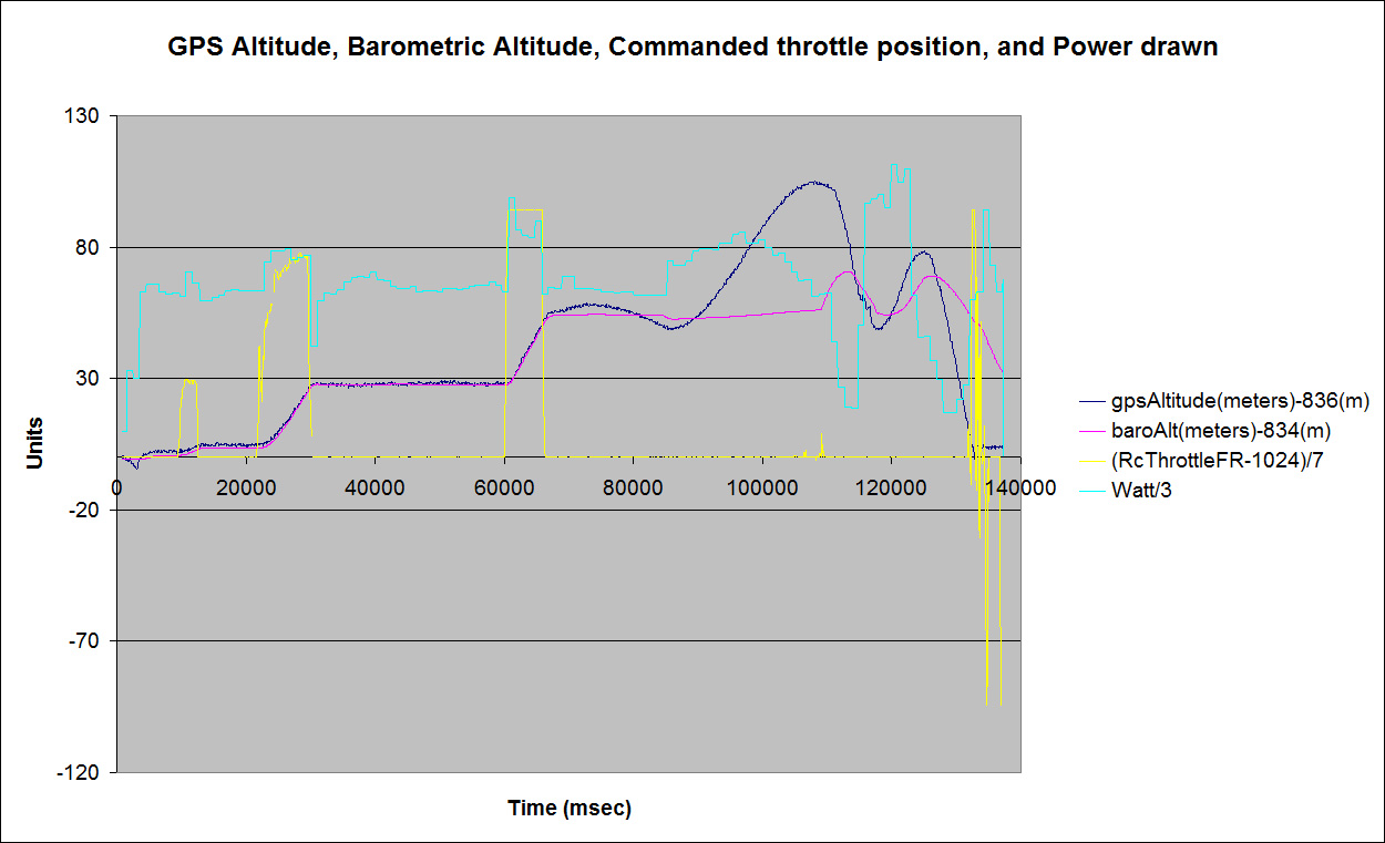
Here is a plot of the GPS altitude, Barometric altitude, Commanded RC Throttle position, and Power used.

GPS_Baro_Throttle_Power.jpg


GPS Altitude = Dark Blue

Barometric Altitude = Magenta

RC Commanded Throttle = Yellow

Power drawn = Cyan


You can see the power draw increase when the motors throttle up, and decrease when throttled down, whether commanded by me or the auto pilot. This is a fair indication of if the quad is trying to climb or descend.


You can see that the barometric altitude and the GPS altitude track each other well until about 67 seconds into flight. At about 86 seconds into flight the GPS shows the altitude under the commanded alt and also shows a small step down in altitude on the barometric altitude.


At this point (when the baro alt steps down about 2 meters or so at about 86 seconds) the autopilot attempts to raise the quad, you can tell this by the increased power draw consistent with throttling up the motors. The GPS altitude shows the quad rising reasonably quickly during this time, but the barometric altitude shows a much slower rise.


At about 108 seconds into the flight the baro pressure reaches the original commanded altitude and the current draw relaxes. GPS altitude shows the craft starting to descend. Barometric altitude also starts to rise, coming in line with the real altitude of the craft momentarily.


From about 108 seconds until impact the aircraft oscillates, porpoises, up and down. The GPS data looks to be responding faster than the barometric data. And the GPS altitude data represents what was happening in the real world according to what I saw/heard and the video recorded.


At about 132 seconds you can see my throttle inputs trying to stop the descent, and the associated power increase, indicating the craft was responding, but it was too late.


At about 135 seconds the GPS data shows the drone at the final altitude, on top of my truck, while the barometric data shows the altitude at about 39 meters up and falling. It also shows an increased power draw for several seconds as two of the blades were obstructed but trying to turn.


To me it looks like the autopilot got behind because of late barometric pressure data. It was responding, but several seconds behind what was happening in the real world. You can clearly see the power draw responding and the GPS alt seems to be tracking what would be expected from that power draw, but the barometric alt was not, at least not in a timely manner.


T!
 
Howdy all,


The recent rains and snows in California have left a lot of image ready landscape out there. Today while driving in the desert I saw an image I had to get, the snow capped Sierra Nevadas on one side and the equally snow capped Panamints on another.


The spot is miles from anyplace, literally in the middle of the desert, in an OHV area, and many miles from the closest structure. Far enough out that I had no cell coverage to use the B4UFLY app on the phone.


So I break out the P4, inspect the aircraft, insert a battery, calibrate the compass, and get ready to fly for a few minutes. The battery had been in the case for a bit over a week, so it was not 100% but still showed over 60% and this was going to be a short hop. The intent was to climb to 100 feet, do a couple slow 360's with video running and then grab some stills in multiple directions, climb to about 200 and do it all again, and maybe up to 300 after that. Land and go home.


The launch point was about 40 feet north of my vehicle. I was just going to go straight up from that to do the imaging.


When I launched I ran it up to about 20 feet to check things out. I did notice the quad seemed to be less stable than I was accustomed to, drifting a bit in location and altitude. Not bad, just noticeably less stable. There was no wind. The quad seemed to stable out, so onward I went.


Up to 100 feet, take the video and images. Up to 180 feet and do the same thing. Most of the time eyes on the drone, but sometimes head down to see how the vid / pics were going. During one point while eyes on the drone I got 6 beeps from the tablet / controller, but when I looked down there was nothing unusual on the screen.


Just before I was going to land, and still hovering at 180 feet, I went head down for about 30 seconds, admiring the image on the tablet. I noticed the world was shifting CCW on the image, so I added some right yaw, but the rotation continued, so more right yaw input from me, not slowing the rotation at all. At about the same time I started to go eyes out to visually find the drone I realized it was getting louder, fast.


I looked up in time to see it plummeting downwards, level flight, all fans turning, far, far faster than I have ever been able to make it descend. Further, it was centered right over my truck, which was behind me in relationship to the launch point. I went full up on the stick, but this did not slow the descent in the least.


The P4 impacted the center of the roof of my truck hard enough to dent the roof, and knock the doors of the over head console open, throwing everything in those pockets out into the cab. Two of the blades got tangled in one of the antennas on the roof of the vehicle, causing a Motor Obstructed warning, the other two blades still turning.


After getting everything shut down I started looking at damage. Surprisingly there did not appear to be much, other than the dents in the top of the truck. One of the P4 blades was broken, from the marks apparently on impact with the antenna.


After an inspection of the P4 I put 4 new blades on it and turned everything on to see if anything worked. The battery still showed over 40%, and all indications were fine. After convincing myself the drone was, maybe, fine I launched it again and flew it, at low level, for a few minutes. There was no sign of abnormal operation.


On playback of the flight on my tablet I can see that at about the time the P4 started the uncommanded rotation CCW it also shot up in altitude about 40 feet, to about 220 feet on the data (if it can be believed). It then slid sideways (to the position over my truck) while visually rapidly descending on the video, and showing a slight descent in the data. On impact with the top of the truck, and the Motor Obstruction warning, the altitude in the date still shows 110 feet above launch point. Obviously it could not be at 110 feet and still be putting those dents in my roof, but either the data is wrong or the World moved.


It might be worth noting the downwards collision sensors appear to have done nothing to stop the impact.


Anyone seen anything like this before?


T!
Hi , I had exactly the same happen to me. Crashed straight into the ground with motors still running! I coulded believe my eyes. The technician that repaired the drone told me to recalibrate the sensors. Still trying to find out how to do that.

Any help will be appreciated
 

Recent Posts

Members online

No members online now.

Forum statistics

Threads
143,094
Messages
1,467,600
Members
104,980
Latest member
ozmtl