Hey, guys, call it quits. I doubt you will convince each other at this point. At the risk of walking into an argument, please let me try one last explanation. I have an MS degree in engineering, a BS in physics, I own a Marco Polo, and I have experience with sailboat (EPIRB) and hiker (PLB) emergency locator beacons.
See generally:
NOAA - Search and Rescue Satellite Aided Tracking - Emergency Beacons
First a little physics. There are several ways that a locator beacon might work:
1) Direct detection of a beacon signal being emitted from a transmitter, the beacon transmitting over some public frequency. (good up to 2 miles in open flat terrain, less in hilly or forested area)
2) The transmitter uses a cell signal to transmit its coordinates to a server via what is essentially a cell call. The coordinates are obtained from GPS satellite signals. The owner calls the server to obtain the coordinates.
3. The transmitter uses a connection to special satellites on the 406 MHz distress frequency. If you have one of these you have to register. See
Emergency Position Indicating Radiobeacon (EPIRB) They are sometimes combined with GPS or 121.5MHz systems. Ones that that hikers or pilots buy might need to be activated at the transmitter, e.g., by the lost hiker or pilot. For maritime use they have water activation. Some are activated when they are tilted (such as in a crash or capsize).
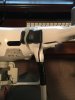
From what I can tell from my own inspection and reading of spec sheets, the Marco Polo is a type 1 system, operating in the 900 MHz band. As such it should have no impact on communication with the RC which uses either 2.4GHz or 5GHz. The limitation to this system is distances, and terrain. The advantage is that it should work when there is absolutely no cell service or satellite service, anywhere in the world.
The "service" based systems (where you pay a monthly fee) must depend on some level of cell signal to get the coordinates to the server.
The EPIRB systems which use the 406MHz distress frequency don't need cell service, but I don't see anything like these being offered for UAV recovery. Also, the 406MHz systems will only get the search time "in the area" and then a 121.5MHz (or 900MHz) signal helps zero in. In any case, if you are getting a 406MHz system you will know, and you will have to register.
Whatever you get, you will need to practice with it, and understand its limitations and benefits. I have no doubt that there will be terrain where one of the systems will work, while the others wouldn't (or be too heavy, etc.) I don't think any of the current UAV systems are perfect for all conditions.
That said, I do like my Marco Polo. The transmitter is very small, and adds negligible weight so it does not affect flight characteristics. As a note, it obviously began life as a dog tracker, and you can have 3 tags registered on one locator, say one for your UAV, one for your dog, and one for your kid.
Hope this helps.
Robert


")