msinger
Approved Vendor
- Joined
- Oct 30, 2014
- Messages
- 31,962
- Reaction score
- 10,787
- Location
- Harrisburg, PA (US)
- Website
- phantomhelp.com


The answer is not to turn off auto RTH in all cases. You can be interrupted, get distracted or anything else that can happen to a pilot that shouldn't. You can always cancel RTH very quickly.I reiterate my strong suggestion to turn Smart Return Home OFF. This entire incident would never have occurred with Smart Return Home disabled. It is a very annoying function, when left on, and won't tell you anything you aren't aready fully aware of, if you are paying any attention to the telemetry. Now, we see that it can also lead to crashes during landing, even if only because the pilot misinterprets what is happening. Shut it OFF!
The default single distance displayed in the app is the distance to the Home Point (which will also be the controller's location, if you haven't moved during the flight, or have successfully reset the Home Point to your current location, by using a GPS enabled tablet or controller), which is recorded before launch by the GPS in the aircraft, and stored on the aircraft, which is how it knows where to go when the controller signal is lost. The aircraft continuously updates this measured distance away from the Home Point during flight through the controller, and passes it on to the app for your viewing pleasure.My apologies, and duly noted, own the proverbial egg on my face. What was I thinking... You must have a GPS tablet to use follow me mode. I cringe to think of the repercussions here. but will man up and own my mistake.
This was not the original question however, which was how the app knows the distance and location from the controller. That I know operates on mine without the tablet radio enabled.
I was simply passing along bladestrike's sage advice, regarding increasing the accuracy of the barometer zero point, by letting it "warm up" and calibrate for some 3 minutes. He didn't say anything about temperature. Barometer readings are based upon pressure, and, with all due respect, I fail to see how a pressure calibration process would be shortened by an increase in temperature. GPS accuracy is enhanced with time if you stand in place, but has no temperature correlation to my knowledge. IMU's are different from barometers. IMU warmups before launch are based upon temperature, which is why the aircraft won't allow takeoff until the original IMU calibration temperature has been reached. There is no requirement before takeoff of a proper barometer calibration. The barometer needs time to accurately calibrate the zero elevation takeoff point, based upon the current air pressure. I doubt that higher temperatures will shorten that time.3 minute warm ups for the barometer should not have been mentioned. There needs to be a known temperature goal point instead. The outside temps during both day and night for most all of us is much warmer now and would require less pre-flight staging.
And more importantly, it would be nice to see actual performance data displaying temp differences with the barometer. No need to create a frenzy about the barometer if it's not necessary.
Great suggestion! I will definitely be ordering one. I have my tablet volume cranked wide open and can barely hear it if there is any other noise around. I had started using wired ear buds but get aggravated with them hanging from one ear.
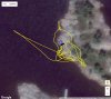
I went to the crash site and flew the phantom around the area, near the trees and near where I recalled it impacting. Have a look at these logs and compare to the crash logs on Google maps or Bing. I also took a video of the flight with my phone, its uploading to dropbox now, I'll post a link when its done.
I think the 3-minute thing needs to be tested before it's accepted as valid.I was simply passing along bladestrike's sage advice, regarding increasing the accuracy of the barometer zero point, by letting it "warm up" and calibrate for some 3 minutes. He didn't say anything about temperature. Barometer readings are based upon pressure, and, with all due respect, I fail to see how a pressure calibration process would be shortened by an increase in temperature. GPS accuracy is enhanced with time if you stand in place, but has no temperature correlation to my knowledge. IMU's are different from barometers. IMU warmups before launch are based upon temperature, which is why the aircraft won't allow takeoff until the original IMU calibration temperature has been reached. There is no requirement before takeoff of a proper barometer calibration. The barometer needs time to accurately calibrate the zero elevation takeoff point, based upon the current air pressure. I doubt that higher temperatures will shorten that time.
I welcome validation of either statement (neither of which I claim credit for), whether time or temperature, is the real controlling factor behind a proper barometer calibration.
I think the 3-minute thing needs to be tested before it's accepted as valid.
It's come from someone that isn't very scientific and not everything he recommends is necessarily true.
I have heard of a few Phantoms with poorly calibrated barometers giving wrong readings but I haven't observed it with any that I've flown.
The specs for the P3 state 0.5m vertical accuracy and the kind of inaccuracies that have been mentioned above is well outside that.
Because I do a lot of flying above the surface of the sea at not very high altitudes, it is important that my altitude reading is reliable and so far it has been on all my birds.
It's easy to do a quick check of your flight records to see if there is any substantial difference between start and landing altitudes and get an idea of whether your altitude accuracy drifts during a flight.
Looks like you flew around various areas there. At what point in the log were you hovering over the spot where it crashed? There's a lot of path data and I want to be sure.
Mike
I flew over the area back and forth, I was thinking the lat.lon will match the crash site. Clearly if I'm flying over it at 6-10' altitude, there are no trees there. When you overlay on Google maps / Bing, you should see the same coordinates from both flights.... It should be easy to confirm where there are trees or no trees.
I tool a video of the drone flying but its still uploading to dropbox.
What I was getting at is that I wish you had hovered for say 60 seconds over the spot where you think the impact occurred so we could compare that. The path looks like spaghetti so it's hard to tell where you actually saw it impact. I wanted to see if that spot lined up on the map.
Mike
I did hover there for about 10 seconds, not 60 though. It's not one of the points when I'm moving. I did hover there for sure.
I fully agree.I think the 3-minute thing needs to be tested before it's accepted as valid.
It's come from someone that isn't very scientific and not everything he recommends is necessarily true.
I have heard of a few Phantoms with poorly calibrated barometers giving wrong readings but I haven't observed it with any that I've flown.
The specs for the P3 state 0.5m vertical accuracy and the kind of inaccuracies that have been mentioned above is well outside that.
Because I do a lot of flying above the surface of the sea at not very high altitudes, it is important that my altitude reading is reliable and so far it has been on all my birds.
It's easy to do a quick check of your flight records to see if there is any substantial difference between start and landing altitudes and get an idea of whether your altitude accuracy drifts during a flight.
However, allowing a barometer to properly calibrate itself before expecting its best accuracy makes intuitive sense. Whether that takes 3 minutes or 2 minutes or a minute remains to be seen, but it should be a constant. I still doubt that it is dependent upon temperature. I am not aware of any check of proper barometer calibration in the app, before launch. However, some research on barometer calibration, in general, is clearly in order. The 10-15 foot drops the P4 still exhibits under old firmware, after letting off the throttle, are of far more concern than the .5m vertical inaccuracy of the P3 barometer. To its credit, the P4 barometer clearly shows those altitude drops, even from 3 miles away! Kind of scary, flying low over the surf!