Return to home

Joined
Jun 2, 2022
Messages
14
Reaction score
2
Age
63
Hi I fly a P3s with a parabolic antenna about 2 miles out over the mountains. Relative to the takeoff point altitudes can reach 800-1200 ft as the terrain varies. My return to home is set at 300 ft for level terrain flying. If I lose RC signal behind a peak at say 800ft will RTH drop me down to 300ft and crash into the mountain returning? Or will it just come home at the altitude signal was lost? I thought best to ask before I get into the situation. Thanks
 
  • Like
Reactions: RodPad
Remember, the drone will return to the home point in a straight line. If the RTH height is set too low, the pilot (you) will need to steer the drone away from obstacles.....like mountains and trees. Otherwise, set RTH as high as needed to clear all obstacles on the RTH flight.

Check the DJI Manual for the P3S Standard, pages 11-15 for other information. Hope this helps....
 
  • Like
Reactions: RodPad
During RTH your drone won't descend to a lower preset elevation before returning. However, as the previous responder mentioned, it will return in a straight (horizontal) line. So, if you lost contact after flying behind a peak, chances are it will hit the peak as it tries to return.
 
  • Like
Reactions: RodPad
I appreciate the insight into RTH. I see I need to train with RTH so I understand what it will do when I need to rely on it. In level terrain I was only using RTH as a last resort backup, I like the idea of setting RTH to terrain plus 400'. I adhere to the 400'altitude limit especially in that remote uncontrolled area because occasionally Seahawk helicopters come through the canyons hot and low, I can see the pilot. Not a problem when I'm under control when I hear them, I drop to below 200'. But if the P3s is under automated RTH control I am uncomfortable with a terrain plus RTH altitude of1200' if only for a couple minutes.


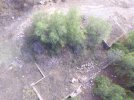
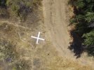
I found a old homestead possibly dating back to the 1800s, with no visible land access beside a rugged hike in. So I'm trying to fully explore the site by air,. One out building possibly a barn is downslope on the opposite side of the mountain. If I drop down for a closer look I will most likely lose control signal. In another site, I think BLM land about a mile to the south I found what I think is a air marker. I don't know if its a research marker, immigrant direction sign or narco drop site. I want to explore that closer but dropping down again would likely put me in RTH control and the only chance to save the P3s if the control signal is lost. Thanks for the help Ill test and train so I can rely on RTH when needed.
 

Attachments

  • homestead.JPG
    homestead.JPG
    4.9 MB · Views: 28
  • Ariel Marker.JPG
    Ariel Marker.JPG
    5 MB · Views: 29
I appreciate the insight into RTH. I see I need to train with RTH so I understand what it will do when I need to rely on it. In level terrain I was only using RTH as a last resort backup, I like the idea of setting RTH to terrain plus 400'. I adhere to the 400'altitude limit especially in that remote uncontrolled area because occasionally Seahawk helicopters come through the canyons hot and low, I can see the pilot. Not a problem when I'm under control when I hear them, I drop to below 200'. But if the P3s is under automated RTH control I am uncomfortable with a terrain plus RTH altitude of1200' if only for a couple minutes.


I found an old homestead possibly dating back to the 1800s, with no visible land access beside a rugged hike in. So I'm trying to fully explore the site by air,. One out building possibly a barn is downslope on the opposite side of the mountain. If I drop down for a closer look I will most likely lose control signal. In another site, I think BLM land about a mile to the south I found what I think is an air marker. I don't know if its a research marker, immigrant direction sign or narco drop site. I want to explore that closer but dropping down again would likely put me in RTH control and the only chance to save the P3s if the control signal is lost. Thanks for the help Ill test and train so I can rely on RTH when needed.
Sounds like a plan. Consider maybe using a tracker also, since you fly in remote areas out of VLOS. I use a Marco Polo tracker on mine, and it is self tracking, and does not need active GPS signals to track the downed drone. Tracker range can be up to 2 miles in flat terrain....... and varies 1/2 to 1 mile in mountainous terrain or heavy vegetation. Plus, the tracker emits a pulse for up to three days if you are delayed by rugged terrain. Good luck exploring the backcountry.
 
  • Like
Reactions: RodPad and Capt KO
I like the idea of setting RTH to terrain plus 400'.
400 ft is too much clearance above terrain for most flying.
It would mean an unnecessary, battery-wasting climb and possibly put the drone up in higher level winds that could be another issue.
It's better to set an RTH height to suit wherever you are flying and whatever obstacles are there.
I found what I think is a air marker. I don't know if its a research marker, immigrant direction sign or narco drop site.
It is a surveyed ground control point for aerial mapping.
There will be others around, put probably miles apart.
 
As one who did lose contact with my Phantom 3 Advanced (around 2.5 miles with parabolic antennas tested distance by flying up the coastline) at the shore, My long distance flights were over water, so no large objects in the way when I did lose signal. it very nicely returned home.

But if you cannot walk to where it *might* get lost, I for one would reconsider the flight. ;)
 
  • Like
Reactions: RodPad
WOW, cool thread!

I will probably add more thoughts on this later.

Marco Polo yes!!

Battery 3 days if its transmitting. Yes

It can last 30 days on full charge.

It only transmits a signal when it picks up the hand unit. Its not going to be transmuting in flight. I don't turn on the hand unit unless I need to look for it.

2 miles as they say mountain top to mountain top. Yes

I have a dog collar also, the dog we have now, will decide to go on a walk about. Anyways at times you may not have a signal at 200 yards. You just keep walking towards where it last pointed..

It doesn't use GPS, or cellular.
Where I lost and still haven't found my P2V+ July 2015. Cellular wouldn't of worked.

I would have found it that day, might still be in an old growth Doug Fir, some of those there must be 220' - 280' AGL.

Never Again.

Rod ..
 
  • Like
Reactions: captainmilehigh

Recent Posts

Members online

No members online now.

Forum statistics

Threads
143,094
Messages
1,467,602
Members
104,980
Latest member
ozmtl