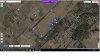
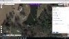
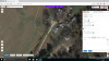
I am planning on flying this mission tomorrow and it is the longest I have done so far with the Litchi app. I am thinking I may lose signal during flight so thought I would ask a few questions. I am probably over thinking this but it seems this week a guy may have lost his drone due to elevation change and with added height of trees and crashed when he lost signal and is not sure where it is. I posted pic of way point 1 it shows 0 feet below 1st way point. Waypoint 6 for example shows ground elevation 513 feet, 2 ft above 1st waypoint. I HAVE ALL WAY POINTS SET AT 110 FEET except for the waypoints in front of barn as drone returns towards way point 1 as I can see the drone clearly at that point and it is open field coming back to start and I should be able to take manual control at that point if needed. My question is will having the waypoints height at 110 feet keep drone at that height at each waypoint? This is basically a flat field a few rolling hills but my take off point is nearly the highest one. thanks for your help


My longest planned flight
- Thread starter drvrbobob
- Start date