Thanks, didnt know that, just hope i find it and know for next time. but will find out by end of today . one thing for sure , its going to be wet.
Yep, I saw that too (from my math it looks more like 27 feet off the ground).
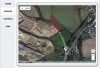
Hmmm. The ground elevation at waypoint no 8 is 32m above the height of the first one. If there was any small trees or shrubs, you could have crashed into them. There might also be some inaccuracies in the actual elevation - there has to be some margin for error. I think that the search should be concentrated around the high ground at waypoint 8.
... it tells you the elevation and relative height above/below the first one.
Walked all way round . Not found. Spmeone else was flying thier phantom thier. Could Not find the flyer.
Sent from my SM-N9005 using PhantomPilots mobile app
You should still be able to logon to Healthy Drones and sync your Litchi flights.I checked healtydrones but I was not logged in. Just sterted using andriod.
Sent from my SM-N9005 using PhantomPilots mobile app
If you click on the Share icon in the upper right corner of HealthyDrones, you will get a link (URL) that you can post here.All this info from healthdrones