I agree the search area for all possibilities is too large. Certainly if you were to assume the bird could've fallen out of the sky at some point on its path. However, there's nothing to indicate it did (likewise, there is nothing that says it didn't either...). It is rare for charged Phantoms to fall out of the sky (even more rare than for them to fly off uncontrollably). It certainly had enough battery to fly for a very long ways. Your battery log data doesn't indicate an error...so I think it reasonable to assume it would've kept heading along its path. That is an assumption though.
However given the track data we do have...it's easy to estimate its path. IF it stayed in the air. Given the rise of elevation of the surrounding land it most likely didn't fly until it ran out of battery. It likely ran into the rising topography. That is one fortunate thing about your situation...the search area does look to be limited by the rising topography.
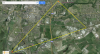
If I wanted to make a targeted and small effort, I'd put signs up on the short few blocks identified in the red area. I also would check the tree line of the park directly opposite as those trees appear to be a substantial barrier at the same location where the obstruction altitude would've met the birds height. The neighborhood identified in the red area is pretty small. It appears the area prior to it is easily accessible being a park. Maybe worth a shot.
I wouldn't say a good estimate of your search area is necessarily 9sq km. I'd think it much smaller...limited to the area of the line where the topography meets the birds elevation.... I don't think I was clear in communicating my previous overlay. I'm not suggesting you search the entire yellow area...just where the yellow polygon meets the earth.
I've included a new overlay (blue). The edges of it is the limit of where the bird could travel without climbing allowing for a wider range of heading than the flight data we do have predicts. It is the terminating edge of this blue polygon where the bird couldn't have flown far beyond without crashing into an obstruction or the ground. A vast majority of it terminates in open fields. Pretty unlikely someone saw it go down, or found it there...also unlikely you can traipse around with a chance of stepping on it. Again here, I'm not suggesting the bird is anywhere in the blue area...just the ground elevation along its terminating edge would've prevented it from going beyond that.
You can just reload the updated .kmz file to inspect the blue polygon.
https://onedrive.live.com/redir?resid=9D9108EB917328CA!1575&authkey=!AD0F4815oUMGUKU&ithint=file,kmz
View attachment 26894