
Disregarding legal issues I pondered this scenario. Place Phantom in middle of open area at home. Install battery and set home point by starting motors and then stopping. Without removing battery drive down the road a couple of miles. Launch from that location with enough altitude to clear any obstacles on rout to home location. Turn off remote and watch phantom fly cross country and land in your yard. I figure I would be good for about 3 miles with my extended battery since I have flown as far away as 1.25 miles and back with plenty battery left. This is just a thought experiment, I would never do it!


You are using an out of date browser. It may not display this or other websites correctly.
You should upgrade or use an alternative browser.
You should upgrade or use an alternative browser.
Fly to remote home point.
- Thread starter Ramz
- Start date
Flying to a remote home point has got me thinking of various ways to do it. This is another possible free way it might possibly be done. It would require sending the NAZA controller uBlox GPS sentences of a remote home point from a computers serial port while setting home position. This may not be as difficult as it sounds. I found free software called "GPS emulator" that I have already tested to output uBlox sentences for what ever GPS coordinates are manually entered. Output from a serial port would have to be inverted and limited to 5 volts with a simple transistor circuit. It seems to reason one could simply install a 3.5mm phone jack in the side of phantom shell that would break the TX data from GPS module when a plug containing ublox data from GPS emulator is plugged in. Now power up phantom or toggle S2 to set remote home point. When the 3.5mm plug is disconnected data from GPS will be re-connected to naza.
I haven't actually tried interfacing anything yet. When or if I get around to it Ill look this post up and ad info.
Thoughts?
Anyone else interested?
I haven't actually tried interfacing anything yet. When or if I get around to it Ill look this post up and ad info.
Thoughts?
Anyone else interested?
Sounds interesting, if the weather clears up a bit, I'll give it a try. Maybe not 3 miles away, but I have a large area of open land I could test it on. I don't see why this wouldn't work as long as you have the battery life for the trip back. I might get brave one day and take it down the road a bit and try it, but for now, I'll just keep it on a fairly short flight path. Longest flight I've done so far with mine was 1 mile out, and I hit rth to bring it back in and it worked out just fine. (have the vid on my youtube channel)
I know on mine if you pick it up with out the motors running and set it back down it re records a new home point every time.
Tho with a p2v the app now has a dymamic home point feature in it that if you enable it it will change the home point based on the gps location of the phone or tablet you are using to make it come home to were ever you move to with the tablet or phone.. So in theory You could set the phantom down some place then drive with the controller and the tablet and it would reset a new home point. BUT only if you are close enough for it to get a wifi signal from the tablet and the app to be able to get the dynamic home points new location which up dates every 30 seconds.
Tho with a p2v the app now has a dymamic home point feature in it that if you enable it it will change the home point based on the gps location of the phone or tablet you are using to make it come home to were ever you move to with the tablet or phone.. So in theory You could set the phantom down some place then drive with the controller and the tablet and it would reset a new home point. BUT only if you are close enough for it to get a wifi signal from the tablet and the app to be able to get the dynamic home points new location which up dates every 30 seconds.
- Joined
- Oct 20, 2014
- Messages
- 359
- Reaction score
- 44
Sounds like a future flyaway to me. I wouldn't want to sacrifice my phantom to do that, I don't know about u guys. Let me know if it works just out of curiosity tho :mrgreen:
Update, success. I can load any home point into NAZA that I choose by entering Lat. and Lon. on my computer screen. I can also view the GPS data. The GPS outputs 7 different U-BLOX sentences which I'll List in a later post along with a schematic and software needed. The $5 parts count is 2 Transistors, 4 resistors, 1 3.5 mm jack and plug.
J.James said:I know on mine if you pick it up with out the motors running and set it back down it re records a new home point every time.
Tho with a p2v the app now has a dymamic home point feature in it that if you enable it it will change the home point based on the gps location of the phone or tablet you are using to make it come home to were ever you move to with the tablet or phone.. So in theory You could set the phantom down some place then drive with the controller and the tablet and it would reset a new home point. BUT only if you are close enough for it to get a wifi signal from the tablet and the app to be able to get the dynamic home points new location which up dates every 30 seconds.
The key to it is Home Point is set when motors are first started. After that you can start, stop, turn off transmitter, do compass calibration and even move it and the home point will remain unless battery is removed or you toggle S2 seven times. I know this to be valid for the FC40 only.
You can set GPS coordinates in your Phantom FC40 and have it fly there autonomously.
This is one way to do it for less that $10 worth of parts.
Let me start by saying do not do this mod unless you are VERY confident of your electronics skills.
I DO NOT KNOW THE LEGALITY OF DOING THIS SO DECIDE FOR YOURSELF.
Also be prepared to loose your Phantom if you program the wrong remote home point coordinates.
Suggest to only fly this mod in non populated area and the first time for a short distance.
If in the short distance test something doesn't seem right switch from fail safe to ATTI mode.
I have tested this mod several times and it does work good, don't blame me if something goes wrong.
I am not recommending this mod and am presenting it here in the case that someone is interested.
The following is how to apply remote home point coordinates.
Farther down I will describe all the software and hardware necessary.
Get GPS coordinates for desired remote home point from Google Maps, Earth or a GPS in
decimal degree DD.DDDDDD format. Be aware Google Maps may be offset from actual coordinates.
Set GPS Emulator parameters and start output.
Power up Phantom by connecting battery.
Wait for NAZA to GPS handshake, "first set of fast blinking light" takes about 5 seconds.
Plug in the 3.5mm serial jack "this interrupts data from GPS and injects data from Emulator.
Caution the next step will require starting motors, remove props or use extreme caution!
Using transmitter start motors "this sets the home point for coordinates set in GPS Emulator"
Using transmitter stop motors and disconnect 3.5mm serial plug from jack.
Don't disconnect battery or home point will be erased. You can turn off transmitter if desired.
Compass calibration can be performed before flight if Phantom has been subject to magnet or metal.
Before flight make sure the LED is blinking green 6+ satellites.
Launch Phantom with enough altitude to avoid any obstacles on rout to remote home point.
Switch transmitter off or set S1 to fail safe.
Phantom will go to remote home point coordinates and land.
Hardware mod:
It will be necessary to convert the active low GPS data to active high that your computers
serial port can read and to convert the computers serial data to active low for the NAZA to read.
This is the purpose of the two transistor circuit.
Using the schematic for reference cut the G-T trace on the GPS modules daughter board and apply transistors,
resistors, wiring, and jack. You will also need to make a cable to go from computers serial port to Phantom.
When the 3.5mm stereo plug is removed the switch in the jack will loop the data back in for normal operation.
When plugged in the GPS data will go in the ring to pin 2 on db9F and data will go from pin 3 on db9F to tip.
Software:
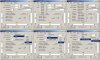
You will need two pieces of software well just one really, GPSEmulator.exe for outputting U-BLOX sentences.
If you want to read the GPS data for troubleshooting then U-CENTER is nice to have, both are free.
U-center
http://www.ublox.com/images/Support/Sup ... _v8.13.zip
GPS Emulator
http://www.happykillmore.com/Software/R ... igTool.zip
You don't have to install GPSEmulator.exe just run it from the unzipped folder.
Ignore the other files in the folder and configure with the following settings.
GPS Emulator settings
Check the following uBlox sentences only.
NAV-STATUS 'Navigation Status'
NAV-POSLLH 'Geodetic Position'
NAV-DOP 'Dilution of Precision'
NAV-VELNED 'Velocity in WGS 84'
NAV-TIMEUTC 'Universal Time Coordinated'
NAV-SOL 'Navigation Solution'
NAV-SVINFO 'Satellite Status and Information'
Baud 57.600
Hertz 4
Precision Format DD.DDDDDD
Speed slider down-0
Set Pitch slider to just above ground elevation for Lat. and Lon. Can get from Google Earth.
Start Laittitude DD.DDDDDD Get from Google Earth. Make sure to set N for North and S for South.
Start Longitude DD.DDDDDD Get from Google Earth. Make sure to set E for East and W for West.
This is one way to do it for less that $10 worth of parts.
Let me start by saying do not do this mod unless you are VERY confident of your electronics skills.
I DO NOT KNOW THE LEGALITY OF DOING THIS SO DECIDE FOR YOURSELF.
Also be prepared to loose your Phantom if you program the wrong remote home point coordinates.
Suggest to only fly this mod in non populated area and the first time for a short distance.
If in the short distance test something doesn't seem right switch from fail safe to ATTI mode.
I have tested this mod several times and it does work good, don't blame me if something goes wrong.
I am not recommending this mod and am presenting it here in the case that someone is interested.
The following is how to apply remote home point coordinates.
Farther down I will describe all the software and hardware necessary.
Get GPS coordinates for desired remote home point from Google Maps, Earth or a GPS in
decimal degree DD.DDDDDD format. Be aware Google Maps may be offset from actual coordinates.
Set GPS Emulator parameters and start output.
Power up Phantom by connecting battery.
Wait for NAZA to GPS handshake, "first set of fast blinking light" takes about 5 seconds.
Plug in the 3.5mm serial jack "this interrupts data from GPS and injects data from Emulator.
Caution the next step will require starting motors, remove props or use extreme caution!
Using transmitter start motors "this sets the home point for coordinates set in GPS Emulator"
Using transmitter stop motors and disconnect 3.5mm serial plug from jack.
Don't disconnect battery or home point will be erased. You can turn off transmitter if desired.
Compass calibration can be performed before flight if Phantom has been subject to magnet or metal.
Before flight make sure the LED is blinking green 6+ satellites.
Launch Phantom with enough altitude to avoid any obstacles on rout to remote home point.
Switch transmitter off or set S1 to fail safe.
Phantom will go to remote home point coordinates and land.
Hardware mod:
It will be necessary to convert the active low GPS data to active high that your computers
serial port can read and to convert the computers serial data to active low for the NAZA to read.
This is the purpose of the two transistor circuit.
Using the schematic for reference cut the G-T trace on the GPS modules daughter board and apply transistors,
resistors, wiring, and jack. You will also need to make a cable to go from computers serial port to Phantom.
When the 3.5mm stereo plug is removed the switch in the jack will loop the data back in for normal operation.
When plugged in the GPS data will go in the ring to pin 2 on db9F and data will go from pin 3 on db9F to tip.
Software:
You will need two pieces of software well just one really, GPSEmulator.exe for outputting U-BLOX sentences.
If you want to read the GPS data for troubleshooting then U-CENTER is nice to have, both are free.
U-center
http://www.ublox.com/images/Support/Sup ... _v8.13.zip
GPS Emulator
http://www.happykillmore.com/Software/R ... igTool.zip
You don't have to install GPSEmulator.exe just run it from the unzipped folder.
Ignore the other files in the folder and configure with the following settings.
GPS Emulator settings
Check the following uBlox sentences only.
NAV-STATUS 'Navigation Status'
NAV-POSLLH 'Geodetic Position'
NAV-DOP 'Dilution of Precision'
NAV-VELNED 'Velocity in WGS 84'
NAV-TIMEUTC 'Universal Time Coordinated'
NAV-SOL 'Navigation Solution'
NAV-SVINFO 'Satellite Status and Information'
Baud 57.600
Hertz 4
Precision Format DD.DDDDDD
Speed slider down-0
Set Pitch slider to just above ground elevation for Lat. and Lon. Can get from Google Earth.
Start Laittitude DD.DDDDDD Get from Google Earth. Make sure to set N for North and S for South.
Start Longitude DD.DDDDDD Get from Google Earth. Make sure to set E for East and W for West.
Attachments
Well I made what I think is an amazing 5 kilometer flight using this mod. I may be just biased because its mine. What do you guys think? https://youtu.be/M-hkQyger3M
Ramz said:Well I made what I think is an amazing 5 kilometer flight using this mod. I may be just biased because its mine. What do you guys think? https://youtu.be/M-hkQyger3M
Ramz,
How many people do you think you put in danger doing that?
Motocrossed said:Ramz said:Well I made what I think is an amazing 5 kilometer flight using this mod. I may be just biased because its mine. What do you guys think? https://youtu.be/M-hkQyger3M
Ramz,
How many people do you think you put in danger doing that?
Motocrossed
How many people do you think you put in danger when you drive 60 mph in a 55 mph zone? Which is illegal and what I did wasn't.
Ramz said:Motocrossed said:Ramz said:Well I made what I think is an amazing 5 kilometer flight using this mod. I may be just biased because its mine. What do you guys think?
Ramz,
How many people do you think you put in danger doing that?
Motocrossed
How many people do you think you put in danger when you drive 60 mph in a 55 mph zone? Which is illegal and what I did wasn't.
And my response to you.
Motocrossed
Last edited:
Motocrossed
Well, threats are uncalled for. I was just inferring there are risks every day in everything we do and that my flight was probably less risk than driving 60 in a 55. What ever you do don't even think about picking up that cell phone if you get a txt while driving.
Best Regards
Well, threats are uncalled for. I was just inferring there are risks every day in everything we do and that my flight was probably less risk than driving 60 in a 55. What ever you do don't even think about picking up that cell phone if you get a txt while driving.
Best Regards
An easier way to do this is using Kenargo's Ultimate Flight app. It has a feature where you can drag your home point to a new position on the map. Then just take off and RTH.
TuT said:An easier way to do this is using Kenargo's Ultimate Flight app. It has a feature where you can drag your home point to a new position on the map. Then just take off and RTH.
I looked it up and it's my understanding that Kenargo's Ultimate flight app requires DJI Light Bridge $1200 and will work with "Phantom Vision, Phantom Vision+ and soon, the DJI Inspire 1". So out of my price range and doesn't even work with FC40.
Well, threats are uncalled for. I was just inferring there are risks every day in everything we do and that my flight was probably less risk than driving 60 in a 55. What ever you do don't even think about picking up that cell phone if you get a txt while driving.
Best Regards[/QUOTE]
Ha! I copied the wrong link, this one is what I meant to post.
Best Regards[/QUOTE]
Ha! I copied the wrong link, this one is what I meant to post.
Motocrossed
Why are you being insulting now? I don't take insults well and don't like it here any more. Thanks for ruining it for me. It is stated in the new rules no insulting or threatening links and you've done both. Moderator you should do something about this guy before he runs other people away.

Similar threads
- Replies
- 28
- Views
- 4K
- Replies
- 7
- Views
- 3K
- Replies
- 8
- Views
- 3K


