Test Flight w/Version 2 Upgrade

Joined
Dec 17, 2013
Messages
54
Reaction score
5
Location
Austin, Texas, USA
After running the update, (there were two update and power off -power on cycles) my stock PV2 accepted the new firmwares with no difficulties.

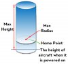
Under the Advanced tab you will find a Limits tab that is preset for a 1600 m by 400 m (about 1 mile x .25 mile) cylinder.

I reset my cylinder to 500 ft x 150 ft for the purposes of this test flight.

In GPS mode (10 to 11 satellites) the PV2 wold not venture outside the range/altitude cylinder. At 150 feet altitude, full left stick up deflection did nothing. I could hear no increase in power to try to fly out of the top of the cylinder. It was as if the climb signal was not sent to the PV2. Still in GPS, the craft flew uprange to 500 feet and stopped as expected, and would not depart the sides of the cylinder.

In ATTI mode the vertical portion of the cylinder stayed intact. I could not fly above the preset 150 foot limit. (I thought in ATTI we'd be able to exceed the cylinder limits.) Again in ATTI mode the craft flew right through the 500 foot radius limit. Once outside the radius limit, I tried to climb above 150 feet, but it would not climb any higher. So, on this test flight, in ATTI, I could fly out of the sides of the cylinder but not the top of the cylinder, and I could not climb above the preset 150 foot limit in either case.

The new 3m/sec descent rate is still generous enough to make an expeditious descent. In fact, I did not try full left stick down deflection; it would have been more than I consider safe for a PV2 descent rate. The 3 m/sec descent rate will NOT prevent rotor vortex issues. In my opinion, we will still have to use caution in our descents to avoid loss of control problems.

I did about 6 or seven (no wind) ground landings. I am normally a hand-landing guy – and will continue to be..., but the landing protocol seemed a bit more docile than before. But just as before we will want to not allow our PV2 to dwell in prop wash ground effect while landing. And we must kill any drift in the landing phase. After that said, I will still hand land my PV2 and not take the risk of landing tip-overs.
 
After this first flight, I looked at what values I could possibly put into the height and radius fields. It allows you to put in any value you want - and it sets them by pushing the Enter key on a PC. So the BVR long and high flyers should still be able to create and fly in large cylinders in GPS mode.

Still not sure why I couldn't go out of the top of the cylinder in ATTI.

So I reset to Default - 1600 m radius and 400 m height and retested. All worked as expected.

On the descent rate - I was still not willing to try full scale left down stick. I think the high altitude flyers will find they still have plenty of descent rate for a safe (non vortex) descent.
 
It seems odd they have not allowed us to change the RTH altitude, I still think 20M is too low... :idea:
 
It's correct that in Atti mode you can break through the geofence but not the ceiling. You'll have to go Manual mode for that. But you set that value for a reason right? I've increased the height value on my P1 gradually from 30m to 150m and don't plan to increase it for most flights. If I ever think I would get significantly better video when I go higher I might try it some day but the legal limit here is 300m and I expect the view will not be dramatically different from that height. Maybe on a clear day with zero wind I will try it just to see what the video will look like.
 
The fisheye effect gets more pronounced in unprocessed video and you lose detail as you go up. You get a "bigger picture" but apart from the initial "ooh, aren't I high" thing it's not that interesting for filming or stills above 500ft in my opinion...

One time it might be is if you have a gimbal that can point straight down and want a plan view of something big... But then again the fisheye...
 
outlaw704 said:
Still not sure why I couldn't go out of the top of the cylinder in ATTI.
Because the altitude limit is based on the baro altimeter (which is still working in ATTI mode) while the horizontal limit is based on GPS (which isn't).
 
dkatz42 said:
Because the altitude limit is based on the baro altimeter (which is still working in ATTI mode) while the horizontal limit is based on GPS (which isn't).

Okay, that makes sense.

This is from the new manual:
In Ready to Fly status (I'm assuming this means GPS), height and distance limits works together to restrict the flight.
In Ready to Fly (non-GPS) status (and ATTI mode), only height limit works and the flying height restricted to be not over 120m.

Max Height & Radius Limits

GPS

Max Height: The flight height is restricted to fly under the max height.
Max Radius: The flight distance is restricted to fly within the max radius.

ATTI

Max Height: The flight height is restricted to fly under the minor height between the Max height and 120m.
Max Radius: Not limited or LED indicators.

(1) If the aircraft flies out of the limits, you can still control your aircraft except to fly it further away.

(2) If the aircraft is flying out of the max radius in Ready to Fly (non-GPS) status, it will fly back
within the limits range automatically if 6 or more GPS satellites have been found.

This last bit is clear as mud - maybe more testing to figure out what it really means...
 
In Atti mode you can fly outside the set geofence. When you switch back to GPS mode the Phantom will autonomously return to within the geofence boundary. If you'd ever lose GPS fix that will effectively be a switch to Atti mode and then you would also be able to move outside the geofence. As soon as the GPS fix would be restored the Phantom would also return to within the geofence boundary.
 
Thanks for posting detailed testing results. I think the geofence feature can be good and since it's optional, it's a nice feature. I was a little worried about the 3m/s descent speed as I typically descend a little faster than that, especially if coming down from very high. But it's probably ok. What I really wish they would allow is for me to specify the RTH descent speed (seems to be about 3.3mph) and the RTH minimum height (20m).

If I set the geofence to something over 1000m for the horizontal limit and fly that far away, it sure would be nice if the app would display the distance instead of that annoying N/A. Anyone tried that yet with 2.0? My P2V is making its way back from a trip - haven't had a chance to upgrade or fly for a few days.
 
nhoover said:
Thanks for posting detailed testing results. I think the geofence feature can be good and since it's optional, it's a nice feature. I was a little worried about the 3m/s descent speed as I typically descend a little faster than that, especially if coming down from very high. But it's probably ok. What I really wish they would allow is for me to specify the RTH descent speed (seems to be about 3.3mph) and the RTH minimum height (20m).

If I set the geofence to something over 1000m for the horizontal limit and fly that far away, it sure would be nice if the app would display the distance instead of that annoying N/A. Anyone tried that yet with 2.0? My P2V is making its way back from a trip - haven't had a chance to upgrade or fly for a few days.

They are always going to keep the autoland descent speeds well below the level where the aircraft could enter a vortex ring state - the autopilot just wouldn't be able to cope with that and a hard landing, at best, would follow...
 
Okay... updates done. I'm off to the testing fields... Wish me luck... ;)

-slinger
 
Does anyone know if the limits are enforced from the home point or are in relation to the TX location? I imagine it's from the home point. If they are in fact enforced from the home point, then people who are not stationary while flying (i.e.. riding in a boat like I will be this summer) will need to be mindful of this and set the radius limits to a number extreme enough to accommodate this type of flying.
 
onesNzeros said:
Does anyone know if the limits are enforced from the home point or are in relation to the TX location? I imagine it's from the home point. If they are in fact enforced from the home point, then people who are not stationary while flying (i.e.. riding in a boat like I will be this summer) will need to be mindful of this and set the radius limits to a number extreme enough to accommodate this type of flying.

Good point.

Sent from my DROID RAZR using Tapatalk
 
onesNzeros said:
Does anyone know if the limits are enforced from the home point or are in relation to the TX location? I imagine it's from the home point. If they are in fact enforced from the home point, then people who are not stationary while flying (i.e.. riding in a boat like I will be this summer) will need to be mindful of this and set the radius limits to a number extreme enough to accommodate this type of flying.


I just tested that and it appears to be from the home point location. I walked about 100 yards away from my home point and flew the P2V to and past the home point and watched the metrics coming in. It showed distance from home point and not distance from TX location. I'm pretty sure I was well past my 300 foot limit, but couldn't tell for sure because the metrics were showing only distance from home point...

-slinger
 
Just came in from my first test with 2.0. It started a little shaky, but for a peculiar reason. This is with a full P2V battery charge, brand new batteries in the TX and a full charge on the range extender last week or so with only a short flight since. I turned on the TX and range extender... plugged the battery into the P2V and turned it on.

I had the max height set at 250 feet and the max distance set for the same. This is a fairly windy day with gusts > 20mph and a threat of rain, so I wanted to test, but keep it pretty close to home.

I set up my TX with the Nexus 7
I put the props on the P2V
I put the P2V on top of the case and the lights were green. All systems go
I took it up to about 12 feet and noticed it was hunting around a bit, but there were wind gusts.
Finally determining everything looked go, up we went.

I then noticed the screen on the Nexus 7 blinking. It would stop and then continue blinking. I shut down the Nexus and turned on my iPhone... same issue. I finally figured out that it was taking timed photos, though I have NEVER set it up to do so. Weird.

Once that was sorted out I brought her up fairly quickly and watched as it hit 246 feet and she would go no higher. I couldn't really see what the lights were doing at the time, but she would not go past that altitude. I took her down to about 60 feet and then sent her slowly down field and watched as we got to around 268 feet before she'd go no further. It looks like the metrics I was getting back weren't aligning perfectly with the distance settings I'd entered earlier... Close... but not exact.

I also tested rate of descent and it is noticeably slower. I didn't attempt a ground landing because of the wind, but I did notice a bit less of a tug while hand landing as I was shutting down the power. Could be my imagination, or an odd confluence of weather, wind, speed, etc... but it was noticeably easier to hand land...

All in all a pretty successful test run. I really like the boundaries, but I think it's going to push me to take my laptop with me so I can change them on the fly depending on conditions, etc...

-slinger
 
I've just come back from flying 2 batteries. Winds at ground level 10-15 gusting 19 on my anemometer - close to my limits - obviously stronger aloft. Flew nicely without an IMU or compass calibration. Descent rate is still plenty, especially if you give it some lateral or spiral motion at the same time. I didn't test geofence as I can't see me ever moving it off the default setting, and I see from you guys it works. :) If DJI ever give the Vision the option to change settings like geofence and gains from the app I think that would be a massive benefit.

So a very pleasant if windy couple of sorties in balmy 65F sunshine. Good job DJI so far...
 
onesNzeros said:
Does anyone know if the limits are enforced from the home point or are in relation to the TX location? I imagine it's from the home point. If they are in fact enforced from the home point, then people who are not stationary while flying (i.e.. riding in a boat like I will be this summer) will need to be mindful of this and set the radius limits to a number extreme enough to accommodate this type of flying.
It has to be the home point, seeing as how the unit doesn't know where the transmitter is (though I suppose the smartphone app could send your GPS location back to the P2V).
 
The flight limits diagram from the updated manual illustrates an interesting issue. Here's my interpretation (I believe you have to have switched from Vision to NAZA-M controls to reset the home point)
The altitude limit is set only during the initial take off procedures. If you reset the home point in flight the altitude limit does not change.
When you reset the home point in flight the lateral limits reference the new home point.
I would test this but we are in the midst of a week of rainy days.
 

Attachments

  • Cylinder.jpg
    Cylinder.jpg
    47.6 KB · Views: 517

Recent Posts

Members online

No members online now.

Forum statistics

Threads
143,094
Messages
1,467,602
Members
104,980
Latest member
ozmtl