


You are using an out of date browser. It may not display this or other websites correctly.
You should upgrade or use an alternative browser.
You should upgrade or use an alternative browser.
Stock P2V 2.7 KM (8,850') Long Range Test
- Thread starter PVFlyer
- Start date
sweet. My brother in_law is from I believe it's called Dunfries. :-/Pull_Up said:Absolutely! Bring your Vision and I'll take you to some old stuff you can film...")
they recently had to go for a visit to see his mom for a surgery that was a success.
That's Scotland. Might be a whole different country if their referendum later in the year goes for independence...
Anyway, we're now waaaaaaaaaaaay off topic!
Anyway, we're now waaaaaaaaaaaay off topic!
LOL indeed :-/Pull_Up said:That's Scotland. Might be a whole different country if their referendum later in the year goes for independence...
Anyway, we're now waaaaaaaaaaaay off topic!
back on track.
Pull_Up said:About 600ft more than mine could ever get stock in FCC mode. I think my part of the world has just been too wet - isn't moisture supposed to be bad for RF reception?! Still, my little 5.8 helical has pushed that out to 2000ft which is more than I'll ever want to use.
I did see this set up when it was just per order and was think of getting a set but needed to do a range test with the stock p2v so I have got something to go on first. its not so much the range am look for but a stronger signal there is some great place's to fly not that far away from were I am but its very rocky ( peak district castleton ) and I tend to lose signal very easy I think it may have something to do with the kind of rock as it does have a lot of quartz in it or it just could be how it is there if I get 500ft am doing well.
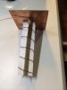
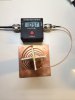
I bought a low-end SWR meter to tune my homebrew helical recently. Before tuned, SWR was as poor as 2.4. After tuned (mainly by removed wavetrap), the best reading I got is very impressive 1.05. I supposed using the wavetrap (following IBCrazy DIY helical post in RCGroup) would match 50 ohm impedance for better SWR, but it seems there was something wrong or my misunderstanding.
Anyway, the SWR looks good now. I hope to test the tuned helical in the coming weekend if weather allows.
Anyway, the SWR looks good now. I hope to test the tuned helical in the coming weekend if weather allows.
Attachments
Got a few PMs recently about various P2V setups, but my replies sitting in Outbox a whole day without sending. It used to work in the past. I'm unsure when those replies will get through.
As I don't check PM very often, please post your questions directly to the thread.
As I don't check PM very often, please post your questions directly to the thread.
Pull_Up said:PMs sit in the outbox until "delivered", i.e. the user opens them.
Thanks for the insight.
I threw me at first until I was online once when I got a reply and saw it had moved, then I twigged how it works.
Lost my P2V
Yesterday, when I did my first battery flight, everything seemed alright. I flew about 2.5KM and landed properly as usual.
When I did the second battery flight (a casual flight 700-800M only), the 5.8G control link lost and triggered RTH which is fine. I know that area having pretty strong 5.8G interference. I watched screen GOING HOME with 70%+ battery and expected it's flying back as usual. I chatted with friends without paying too much attention on the screen. When I looked back the screen again, the screen showed something odd. I was aware it landed (either dropped from sky at 50M altitude or auto-landed itself) somewhere. I used Find My PHANTOM 2 VISION, it showed my P2V landing about 200M away.
I thought a bit lucky because it's not landing in the ponds (somewhere between 2 ponds). I'm so sure it landed/dropped in some 2M height rough/reed as I could see yellow light flashing on the screen. I walked along a very narrow trail to the GPS location. The shame is I could not find it after searching a few hours together with 2 friends. I turned on Wifi Analyzer and spotted the strongest signal point is -44dB, I know well it's only within 10-20M away from me, but no luck to rescue it yesterday.
I know the only chance is to spot the exact location, then chop down the rough/reed and try to reach such location straight the way.
Today, I borrowed another P2V from a friend. I flew 2 flights scanning through such area (20Mx30M) multiple times at 6M altitude with camera facing down. Obviously, 640*480 resolution Vision app is insufficient to spot P2V down into 2M height rough. I came home and scanned through 2 videos (total 30 mins) by 1920*1080 with my 27" monitor a couple of times, but still no luck.
It's impossible to scan all 54,000 frames (1800 seconds * 30 frames per second) by human eyes. Thus, I sent the 2 video files to my friend, and asked his help to code a software scanner scanning white/blue pixels from the videos.
I have a feeling like searching Malaysia Airline MH370 from Indian Ocean. God bless the people on MH370. Hope to get some good news from my friend soon.
Attachments
- Joined
- Mar 20, 2014
- Messages
- 13
- Reaction score
- 0

Re: Lost my P2V
Very sorry to hear this! I am surprised with all of your expertise, that when experimenting with long range flights that you don't use a tracker of some type. I have been experimenting with a few models here;
http://www.rcgroups.com/forums/showpost ... count=8486
I wish you only good luck in finding your bird!
PVFlyer said:Yesterday, when I did my first battery flight, everything seemed alright. I flew about 2.5KM and landed properly as usual.
When I did the second battery flight (a casual flight 700-800M only), the 5.8G control link lost and triggered RTH which is fine. I know that area having pretty strong 5.8G interference. I watched screen GOING HOME and expected it's flying back as usual. I chatted with friends without paying too much attention on the screen. When I looked back the screen again, the screen showed something odd. I was aware it landed (either dropped from sky at 50M altitude or auto-landed itself) somewhere. I used Find My PHANTOM 2 VISION, it showed my P2V landing about 200M away.
I thought a bit lucky because it's not landing in the ponds (somewhere between 2 ponds). I'm so sure it landed/dropped in some 2M height rough/reed as I could see yellow light flashing on the screen. I walked along a very narrow trail to the GPS location. The shame is I could not find it after searching a few hours together with 2 friends. I turned on Wifi Analyzer and spotted the strongest signal point is -44dB, I know well it's only within 10-20M away from me, but no luck to rescue it yesterday.
I know the only chance is to spot the exact location, then chop down the rough/reed and try to reach such location straight the way.
Today, I borrowed another P2V from a friend. I flew 2 flights scanning through such area (20Mx30M) multiple times at 6M altitude with camera facing down. Obviously, 640*480 resolution Vision app is insufficient to spot P2V down into 2M height rough. I came home and scanned through 2 videos (total 30 mins) by 1920*1080 with my 27" monitor a couple of times, but still no luck.
It's impossible to scan all 54,000 frames (1800 seconds * 30 frames per second) by human eyes. Thus, I sent the 2 video files to my friend, and asked his help to code a software scanner scanning white/blue pixels from the videos.
I have a feeling like searching Malaysia Airline MH370 from Indian Ocean. God bless the people on MH370. Hope to get some good news from my friend soon.
Very sorry to hear this! I am surprised with all of your expertise, that when experimenting with long range flights that you don't use a tracker of some type. I have been experimenting with a few models here;
http://www.rcgroups.com/forums/showpost ... count=8486
I wish you only good luck in finding your bird!
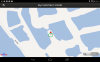
Raymond.HK said:Dear P2VFlyer,
Could the location (about 250m) be somewhere here:-
Raymond
Thanks Raymond for the information.
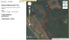
I think I located it (red spot) while the Vision app GPS data (based on Baidu map) showing it at blue dot, which is 10-15M away from the trail and near a pond. The problem of Baidu map in the Vision app is no satellite view.
I need to verify the exact spot, and get a machete chopping down 2M height reed to reach there. I tried hard on last Saturday, but I could only move 2M (out of 15M) forward and blocked by the reed. I probably also need a rescue rope in case sinking in mud nearby the pond. I also bought a fishing pants with shoes, like this http://www.aliexpress.com/store/product ... 77499.html
Anyway, my rescue approach is "assume nothing, prepare everything".
Attachments
- Joined
- Mar 20, 2014
- Messages
- 13
- Reaction score
- 0
"Find My Phantom" in DJI Apps is not accurate, particularly when you really have to use it.
So always check in advance before and after each use how far its map location will be different from the actual spot.
In my last time flyaway, the P2V travelled about 620 m (measured from Google Earth) after several minutes of mad flying from home position and it landed on the hill slope.
The DJI Apps showed that it should be on the road predicted at some 1.3Km from home position, but the predicted position of the P2V was double of the the actual position.
I went to the predicted location and of course could not find it. Then used a pair of small binocular to spot the P2V uphill.
Raymond
I have one of these on the way as a backup GPS system just in case. Figure for the price it is well worth it and it can have multiple uses.
http://www.ebay.com/itm/Car-Vehicle-GSM ... 485850bd26
http://www.ebay.com/itm/Car-Vehicle-GSM ... 485850bd26
HaM-73 said:I have one of these on the way as a backup GPS system just in case. Figure for the price it is well worth it and it can have multiple uses.
http://www.ebay.com/itm/Car-Vehicle-GSM ... 485850bd26
Reading the info on this unit, it sounds like you need a sim card from your cell provider, which also means you have to be in a 'cell service' area. Here in Nevada, I fly a good portion of the time, out in the 'middle of nowhere' and cell service is nil. Probably won't be able to use this. But let us know what your experience is.
I have this eXact same unit. You can strip it down and make it about 30grams.HaM-73 said:I have one of these on the way as a backup GPS system just in case. Figure for the price it is well worth it and it can have multiple uses.
http://www.ebay.com/itm/Car-Vehicle-GSM ... 485850bd26
I've posted quite a bit of info on this unit. I use the h2o $10 dollar sim. good for 90 days. works perfect. CAUTION DONOT use the magnetic battery door. It will whack up your compass!!!
Skipholiday said:I have this eXact same unit. You can strip it down and make it about 30grams.HaM-73 said:I have one of these on the way as a backup GPS system just in case. Figure for the price it is well worth it and it can have multiple uses.
http://www.ebay.com/itm/Car-Vehicle-GSM ... 485850bd26
I've posted quite a bit of info on this unit. I use the h2o $10 dollar sim. good for 90 days. works perfect. CAUTION DONOT use the magnetic battery door. It will whack up your compass!!!
Thanks Skip for the heads up. Hopefully the thing will come with a non-magnetic battery door also.
Similar threads
- Replies
- 3
- Views
- 2K
- Replies
- 6
- Views
- 5K
- Replies
- 9
- Views
- 3K
- Replies
- 5
- Views
- 1K


