Mechanically, how high can I go?

But it is limited by firmware so the only answer you need to give is that it can go to 500 metres.
The rest is unnecessary complication to the people casually asking you how high can that fly?

I'll admit I get caught up in specifics and semantics.

If I'm asked "how high can "you" go", I'll say 300'. Me, I can go 300'. That's what Transport Canada tells me, and if you don't know who you're talking to, that's the safe answer.

If I'm asked "how high can "that" go", they get the 500 m or 6000 m answer.
 
Correct - that would require both a digital elevation model (DEM) for the terrain plus a database of all structure heights, potentially even tree heights etc. The DEMs exist, although would be a bit of a memory hog, but I'm not sure the structure database even exists.

...and with that, I don't think there is a single further question that can be asked.
 
In this scenario, wouldn't you have to descend to the point in blue if you flew over that cliff, to comply with FAA guidelines?
1e35e61b6c4f5a54d0e9fc651a468c32.jpg
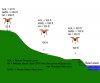
There are things you should be concerned about and things you don't need to worry about.
If you are considering flying over a cliff edge and staying within say 100 feet of the cliff, it won't matter how far below the ground is.
Planes are not going to be close to a cliff face and the FAA isn't going to have a man on a long ladder with a tape measure.
If you want to fly way out from the cliff edge, it might be an issue.
 
  • Like
Reactions: Loz
Ok sar104 that's what I'll do,,I've landed at the bottom and it's just about -200' alt,thanks. McGrath you ask some great questions,,very informative,thanks to you also
 
  • Like
Reactions: jwmcgrath
All of which becomes irrelevant in a legal scenario apparently, since we must yield to actual aircraft always.

So unless you want to feel good that you are flying legal, because I have no idea how else you'd get pinned for it, it doesn't matter so long as you don't hit planes. Which in theory is why you'd stay under 400ft or whatever the limit is. Buuut, some aircraft ignore this rule or there might be some exploit you don't know about, so you could be flying legally in your mind and still be at fault for a wreck?

Am I wrong about this?

No you're not wrong. You're dead on.

As per another thread, I have a trailer parked in a campground within which the owner flies an ultralight right off the property... taxis out from his hangar/shed, takes off and lands from the water 200' from the boat docks.

There is plenty of time he is below 400'. If we collide, below 400', who's at fault?

Technically me, as there is a requirement to yield to manned aircraft.

But I was flying legally the whole time.
 
All of which becomes irrelevant in a legal scenario apparently, since we must yield to actual aircraft always.

So unless you want to feel good that you are flying legal, because I have no idea how else you'd get pinned for it, it doesn't matter so long as you don't hit planes. Which in theory is why you'd stay under 400ft or whatever the limit is. Buuut, some aircraft ignore this rule or there might be some exploit you don't know about, so you could be flying legally in your mind and still be at fault for a wreck?

Am I wrong about this?

That's true. Although one other way you might potentially get into trouble would be if the FAA, responding to complaints or events perhaps, obtained your DJI flight records.
 
I'm not sure where you got that idea from. It doesn't make any sense
At ground level is ground level.
About 3 seconds on Google will show that AGL is Above Ground Level.
Or to see what the FAA says: Definitions
Or: http://atbasics.faa.gov/secured/pdfs/SLP 01-Resources.pdf

Your app does not give you AGL anything.
It's telling you how high your Phantom is above launch point which is not AGL unless you are somewhere flat.
In my illustration the phantom's altitude (agl) is how high the Phantom is above the ground (which is below it) and where it was launched from is irrelevant.
The term above ground level is self explanatory and shouldn't need any explanation.
But if you need it spelled out try this:
What is the difference between Above Ground Level and Above Field Elevation?

Okay, so you know I'm not a pilot. I concede to you your point which is well taken. I have always thought logically about agl being wherever you were was the actual agl. However, when the app from a big company like DJI and their product a quad copter tells you your height is only from where it took off but you are over a cliff and it doesn't read the true agl, I went with what the app told me which was made by the makers of the quad. In reading your links (thanks) I find that only some aircraft have radar altimeters and can actually read true agl, meaning that the entire industry can't have true agl. It's like a compass when you grow up learning about north (thought I knew everything), and then you learn there is true north as well. Either way, I have said before that if I respond to this forum and I'm wrong, you of more education will set me straight and I'm really happy for that. Thanks and thanks to loz on this forum too. So then, we fly way over our FAA limit guideline many times. Interesting. Hope I didn't take us to far off topic of how high can we go. Thanks to the OP too for asking his question which brought up many points.
 
Well that's grand isn't it? I suppose we have only a few options then.

We can cross our fingers and hope for the best, and just avoid airports and other heavy aircraft traffic areas

We could fly in line of sight at all times [why on earth would you do that?]

Or you could I guess somehow keep track of every plane in the air or at least purposely crash land every time red baron skims the trees around the house.

I pick the just try and fly as smart as we can and not stress too much about it
 
  • Like
Reactions: NRJ
NRJ this sounds like the earth is flat argument of yester-year. The reason they have pilot licences is to learn and understand what the instruments are telling a pilot to fly safely. Likewise understand the limitations of the Phantom Instruments - the app, its telling pilot height above or below take off point (as you appear to have confirmed) NOT height above ground (AGL). The app gets this info from a Phantom built in barometer that measures air pressure, it has NO concept nor tries to understand height AGL, only height (air pressure)change from take off point.

Now back to fly off mountain example - the air pressure is same (for purposes of this example) when a Phantom flies sideways away off the top or side of a mountain, so displayed 'height' on DJIGo app will stay same, but we know that the phantom is actually now possibly hundreds of feet above the valley below the Phantom (AGL), and quite possibly flying way above legal / recommended flight height. Make sense? hopefully.

Thanks Loz. You actually explained it pretty well logically and I would agree. My problem was leaving logic behind and going with what the quad and app was telling me. You and Meta4 have set me straight and it's not all about me and my bird. There is a whole world out there of aircraft that can't read true agl either. Meta4 gave me a couple links which backup what you and he are both saying. Thanks for chiming in and happy flying.
 
  • Like
Reactions: Loz
There is a whole world out there of aircraft that can't read true agl either.
That's a good point.
In general aviation, most small planes have a barometric altimeter just like our Phantoms.
They calibrate it to give a reasonably accurate altitude above sea level (so they can relate their height to mapped mountains etc.
But when it comes to agl heights they still have to work that out themselves, just like a Phantom pilot.
 
  • Like
Reactions: NRJ
That's a good point.
In general aviation, most small planes have a barometric altimeter just like our Phantoms.
They calibrate it to give a reasonably accurate altitude above sea level (so they can relate their height to mapped mountains etc.
But when it comes to agl heights they still have to work that out themselves, just like a Phantom pilot.
Another reason pilots read sectionals - local ground elevations. Gets more complicated for pilots on long legs, barometric pressure can change enough to affect the readings and mess up your estimate of how high above the runway you are. That's why towers usually give pilots local pressure when they call in so they can adjust the altimeter to local pressure thereby correcting altitude. Obviously, not a problem for Phantoms, we usually don't have the bird up long enough to be affected by any changes in atmospheric pressure.
 
  • Like
Reactions: Loz
This thread is a flyaway with all of these 400' comments.

Hypothetically speaking, I suspect the Phantom could climb to the point it didn't have enough battery to land.

SB
 
This thread is a flyaway with all of these 400' comments.

Hypothetically speaking, I suspect the Phantom could climb to the point it didn't have enough battery to land.

SB

...or the point that the air was so thin that the propellers couldn't displace it enough to lift the bird, and that depends on the elevation you start at! [emoji6]

All this talk makes me respect the Wright Brothers all that much more, I gotta say.
 
altitude1.jpg
 

Attachments

  • AGLMSL.jpg
    AGLMSL.jpg
    118.8 KB · Views: 487
Last edited:
  • Like
Reactions: Loz
That's an awesome diagram...

But... are you sure?

Either I'm wrong or the the "Alt" reading, which you have defined as the "altitude the Phantom tells you" is off...

At point 1, reading left to right, you show the Phantom at 30' off the ground but the Alt reading as 200'... shouldn't the Alt (the altitude the phantom tells you) be 30'?

Or is it the way I'm reading it?

EDIT: Never mind, your edit came through as I was typing, and I had the takeoff point at the left, reading left to right!
 
  • Like
Reactions: Pharm
Sorry, so far in this thread everyone was "flying off a cliff" so I started at the high side. Goes to show how simple one detail can change everything...
 

Recent Posts

Members online

No members online now.

Forum statistics

Threads
143,096
Messages
1,467,620
Members
104,981
Latest member
brianklenhart