


Recent content by EdRickerVlogs
-
E
Terrible video transmission...
This. I too struggled with some bad image transmission problems, but I lowered the video transmission bitrate and it instantly fixed my problem.- EdRickerVlogs
- Post #8
- Forum: Phantom 4 Pro Help
-
E
The Dry Spell - A Narration with the Phantom 4 Pro (and Mavic)
Thanks for watching, everybody!- EdRickerVlogs
- Post #6
- Forum: Photos and Video
-
E
The Dry Spell - A Narration with the Phantom 4 Pro (and Mavic)
Hi all, I wanted to share a video I recently uploaded to my YouTube channel. It's called The Dry Spell, and it's a short story from the perspective of a dried up lake. Footage was taken over the past December-July using the Phantom 4 Pro as well as the Mavic (depending on what I was flying that...- EdRickerVlogs
- Thread
- Replies: 5
- Forum: Photos and Video
-
E
Dropping Things From Drones?
Wow, way to resurrect a thread Phantom1972! Since it's resurrected anyway, I'll share the videos we made of the product/activity this thread was originally posted about. And yes, for some reason a lot of people really didn't enjoy them. They thought it was reckless and a bad example to...- EdRickerVlogs
- Post #9
- Forum: Rules and Regulations
-
E
AirMap.io Distinctions: Commercial vs. Airspace
Thanks, I'll check it out I appreciate everyone's answers about the AirMap distinctions. Thanks!- EdRickerVlogs
- Post #10
- Forum: Rules and Regulations
-
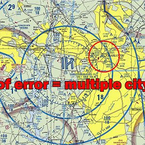
Charlotte Airspace
- EdRickerVlogs
- Media item
- Comments: 0
- Category: Aerial Photos
-
E
AirMap.io Distinctions: Commercial vs. Airspace
I checked SkyVector.com and VFRMap.com, both sectional charts. However, I appreciate the fact that apps/websites like B4UFly and AirMap have actual streets/landmarks with the airspace radius' superimposed. Sectional charts just aren't accurate enough for me, especially when we're talking about...- EdRickerVlogs
- Post #8
- Forum: Rules and Regulations
-
E
AirMap.io Distinctions: Commercial vs. Airspace
Hi all, I've been researching flying in a few big cities around the USA and have been studying AirMap.io to figure out what's possible. I noticed that selecting the "Commercial" toggle button shows the limits around airports clearly, but selecting the airport Class shows a larger radius around...- EdRickerVlogs
- Thread
- Replies: 16
- Forum: Rules and Regulations
-
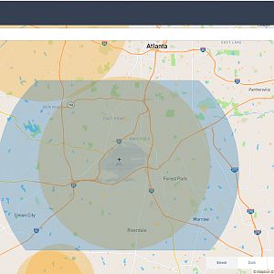
AirMap Atlanta
- EdRickerVlogs
- Media item
- Comments: 0
- Category: Aerial Photos
-
E
Dropping Things From Drones?
Thanks for chiming in everyone!- EdRickerVlogs
- Post #6
- Forum: Rules and Regulations
-
E
Best phantom 4 pro backpack
Check out the video I made for the PolarPro Drone Trekker ($130 USD):- EdRickerVlogs
- Post #4
- Forum: Phantom 4 Pro Help
-
E
Dropping Things From Drones?
Hi all, I run a YouTube channel called Ed Ricker Vlogs and do product reviews for drone/camera accessories. A Chinese company called "FLIFLI" sent me a message asking if I'd be interested in receiving/reviewing their new "drop release device" for Phantom 4 drones: Amazon.com: FLiFLi AIRDROP...- EdRickerVlogs
- Thread
- Replies: 15
- Forum: Rules and Regulations