DJI GEO 2.0 - now new problems

Joined
Jun 9, 2017
Messages
88
Reaction score
37
Location
Palm Beach County, FL
So now Geo2.0 is out what does this mean?
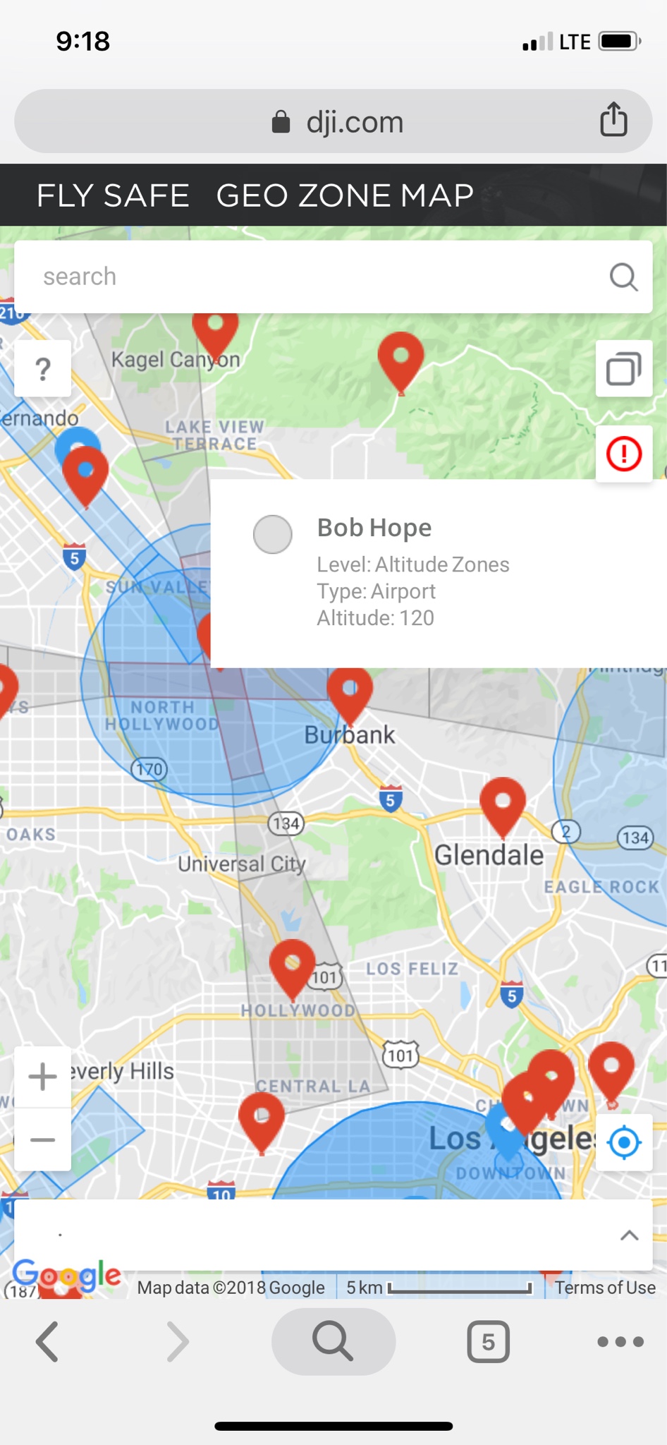
"Altitude Zones: Altitude zones will appear in gray on the map. Users receive warnings in DJI GO, or DJI GO 4 and flight altitude is limited." when you click into theses areas you are presented with a Altitude number is this Feet or Meters? Why does the runway boundries extend so far past the airspace on the sectionals?

I fly a monthly construction job that is free and clear of a class e airport where I take a overhead shot of the site at about 500 feet (within 400' lateral of a 300' building) so now I look at DJI - The World Leader in Camera Drones/Quadcopters for Aerial Photography and it looks like they have this location in a "Altitude 120" zone? Are these unlockable areas? I would prefer DJI stay out of us 107 operators business.

Untitled.jpg
 

Attachments

  • Untitled.jpg
    Untitled.jpg
    91.2 KB · Views: 988
update...i heard back from dji.
"We have 2 kinds of Altitude Zones ,60 meters ,and 120 meters .So the number is in meters"
"DJI - The World Leader in Camera Drones/Quadcopters for Aerial Photography is according to AIRMAP and designed to provide some general protection to sensitive locations around the world, not to match any particular set of regulations that apply to a certain user. If you need to unlock any altitude zone ,please submit custom unlocking online with authorization....if you have encountered an 120 meters Altitude Zone ,and you need to fly over 120 meters ,then please submit an custom unlocking"

So the geo2 goes beyond what the faa requirements are. I wish they would have the ability for 107 pilots to override all this garbage. Requiring a dji approval to fly in a class g airspace seems to be a big over reach.
 
Last edited:
  • Like
Reactions: spaceweasel
Agreed, it makes absolutely no sense to limit flight altitude
622e1418fb71f2f9a6596f0c52cc6d02.jpg
to 120 feet In class G airspace near Santa Monica Blvd. when there is a mountain between it and Bob Hope Airport
 
I operate in area that is barely above sea level no mountains hills etc. but if the altitude zone extends into a hill or mountainous area that would be 400’ AGL above your take off point are you going to be limited flying towards it also? I’m pretty sure the altitude zones do not take into account AGL. I guess it’s yet to be known if the altitude zone takes into account for elevation change to allow for true 400’ above ground level.
 
Last edited:
Is there a way to see the changes in my area without downloading the app update? Their website says, under the map, that not all geozones are displayed. Thx.
 
Maybe thier website says that as legal speak so they are covered if they miss something and a pilot relies only on their data. I for one contine to click ignore update on start up, wonder how long that lasts till it become mandatory. I have not yet flown into a ‘altitude zone’ to see if I’ll be limited.

I’ve been try to look closely at all the different runway ‘altitude zones’ and for the most part the 120’(60meter) zones are real close the edges of class e d c b etc but the 400’(120meter) zones really bug me. If you have a job where you are legal above 400’(near a structure) or working up a elevation where you could still fly 400’AGL but maybe 400’ above your take off point.
I know that I live near a couple of charted seaplane bases. Within a couple miles. Not very active but on the chart. I get some kind of warning now but am not prevented from flying. These do not show up on the website geozone map so apparently they do leave some out.

I’m concerned if I update the app I’ll be prevented from flying or will be altitude restricted. I also ignore the database update but I can’t be sure I’ll be ok if I continue to do that. Such as maybe the new version of Go 4 will enforce the limits due to those seaplane bases near me.

Edit: I should include Litchi in my concerns because there is an update pending to support Geozone 2.0
 
Last edited:
Also.....I’m also not sure how the altitude zones are handled when a class d airport is closed. Example some class d are closed on sunday mornings where the altitude zone should technically not be in effect. I’m all for good safety systems and measures to WARN but let the pilot be the final decision maker at the time of flight. Just like the manual unlock where you basically assume full responsibility. This altitude zone stuff should be the same way with out having to wait for a DJI unlock. if this geo 2 is not 100% accurate 100% of the time then it should be tossed out.
 
I’ve had no problems with Litchi even though I am on the border of an airport fan. I never update anything except Litchi and no issues of pop ups calling for an upgrade. Just stating a fact. Litchi may not solve the problem but it has prevented any such issues for over two years here.
Good luck
Jim
WA5TEF
 

Members online

Forum statistics

Threads
143,096
Messages
1,467,625
Members
104,982
Latest member
AnndyManuka