
- Joined
- Feb 10, 2017
- Messages
- 291
- Reaction score
- 126
- Age
- 63
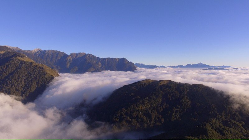
Yeah, that was utterly fascinating.
It is actually for the people living up here who have not seen the area they live in from that perspective.


Yeah, that was utterly fascinating.
No Google Earth?It is actually for the people living up here who have not seen the area they live in from that perspective.

Forest Hill Bridge is 900 feet above the river below. The mountain tops are another 400 feet above the bridge level. I'm standing at river level, how high can I fly my drone?
Sent from my iPhone using PhantomPilots mobile app
No, 400 (when applicable) is always in reference to the ground under the bird, or the structure under or near it.Its 400 feet from your launch location so launch from the bridge or even climb the 400 feet to the top of the mountain and launch from there.
If you are challenged your drone logs in healthy drones will show altitude at launch and max altitude of flight and also your latitude and longitude points as you fly.
Forest Hill Bridge is 900 feet above the river below. The mountain tops are another 400 feet above the bridge level. I'm standing at river level, how high can I fly my drone?
Sent from my iPhone using PhantomPilots mobile app
Agreed. Nothing wrong with the roadside at either end of the bridge though, if there's a bit of room.I definitely wouldn't launch from that bridge. All that metal is going to screw with your compass (ask me how I know )
Part 107 says that you can fly 400' above the subject matter being filmed as long as you're no farther than 400' away from that subject matter.
For example, a 10 story building is 150'. You can fly up to 550' above that building as long as you're within a 400' radius of the building...
Indeed. Ideally, you should have an altimeter or a Topo map to tell you your launch altitude above sea level, before launch, so you can manually calculate true AGL during your fight, based upon the elevation of the ground level below your aircraft.
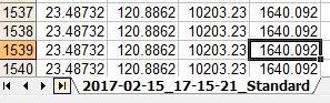

Unless you have 1.03.0509 installed, and can modify parameters!For most I would say 1640ft
Unless you have 1.03.0509 installed, and can modify parameters!
Perhaps this will show the fault in that logic:I would guess the 400' is measured from the ground where you took off. That's what the app measures when it shows height. If you want to fly 400'above the bridge then take off from the level of the bridge. Just my opinion

Or... 1.7.6Unless you have 1.03.0509 installed, and can modify parameters!
You have to qualify the flight first. Then you can quote the applicable rule.https://www.faa.gov/regulations_pol...s/aviation/media/remote_pilot_study_guide.pdf
Title 14, volume 2, part 107.51. You can not fly any higher than 400' agl or 400' radius from structure and not exceeding 400' from tallest portion of building. So, as long as he stays within 400' of bridge, he can fly 400' higher than bridge.


