RTH hight settings in vision app iphone

Joined
Jan 26, 2015
Messages
71
Reaction score
10
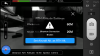
I have a question regarding what does the attached menu option in the screen capture do.

I had an issue while using the ground station app: i set it up to certain waipoints and the last waypoint was 20m. The return to home hight was also 20m but for some reason it allmost hit a tree which was not more than 10m i think!

Does this have something to do with my starting home point which was 5m aprox. higher than the tree location or not?

I would have liked the minium hight for return to home to be dinamic and always 20m or more than the drones current location not to the starting point!
 

Attachments

  • IMG_3180.PNG
    IMG_3180.PNG
    1.3 MB · Views: 616
In your screenshot, you can see your Phantom thinks it's 12.9m in the air -- but, is really only a meter or so since it's sitting on a desk. So, if the RTH/waypoint altitude is set to 20m, it will only really be 7.1 meters in the air.

Do the advanced IMU calibration in the Phantom Assistant application. That might improve that altitude issue. I've never seen mine set to 0 when on the ground, but it's usually only off by about 1m.
 
I assume the altitude is relative to ground lever bellow the phantom .. not sea level which is usual for gps navigation machines?

Because if its sea level its still wrong as i am about 50m above sea level..

Also as there is no GPS signal that is why the altitude is wrong i think as the barometer sensor i not very accurate i think!

Finally another question.. If i press the "set Aircraft Alt. as RTH Alt. does it mean i will fly to 60m+ 7.1m??
 
The Phantom has no way of knowing sea level or height above the ground.
The only altitude your app shows is above or below wherever the Phantom is started up.
GPS accuracy is fine for horizontal position but for altitude it can be +/- 100 feet or more.
The barometer is more accurate than GPS for altitude - which is why the Phantom does not use GPS for altitude.
 
lfaitas, I see nothing in the DJI Phantom manual that shows whether the waypoint altitude is the altitude that shows on the DJI Vision app OR the home point altitude plus the preset waypoint altitude. If it's the altitude that displays on the DJI Vision app, then that might explain the difference you saw.
 
Meta4 said:
The Phantom has no way of knowing sea level or height above the ground.
The only altitude your app shows is above or below wherever the Phantom is started up.
GPS accuracy is fine for horizontal position but for altitude it can be +/- 100 feet or more.
The barometer is more accurate than GPS for altitude - which is why the Phantom does not use GPS for altitude.


So if my phantom is landed then it should show 0 altitude wherever it is.. matsu pitsu or the everest or at sea level!!

So if its showing 12-15m on my desk it is wrong ! I did an advanced re-calibration but it did nothing to change that.

As i understand the only sensor the phantom has to determine the altitude when there is no gps lock is barometer.. there is no radar or sonar of course .. but the barometer is not that accurate.. it varies with weather pressure etc etc..

But how does it manage to hover correctly whithout going up and down when its flying? .. which means that the barometer and gps combo works to keep it in vertical position... unless it is using another way to do that??
 
The Phantom uses GPS to maintain horizontal position but not for altitude at all.
That's what it uses the barometer for.
The barometer is quite accurate - much more accurate than GPS for vertical measurements.
This is why the Phantom holds altitude so well.
If your Phantom doesn't show zero altitude at home point, it is out of adjustment.
 

Members online

Forum statistics

Threads
143,087
Messages
1,467,534
Members
104,965
Latest member
cokersean20