Need some help!

Joined
Jul 17, 2014
Messages
28
Reaction score
0
Location
Atlanta, GA
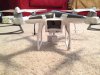
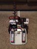
I experienced one of thee worst things that can occur to a phantom pilot, a flyaway. I was at 10k ft laterally and 2k ft up when the signal on both sides was lost. Never returned and have no clue where it went. My question is will a stock controller with stock antennas work with these antennas that I installed on the aircraft?
 

Attachments

  • image.jpg
    image.jpg
    692.7 KB · Views: 404
They will "work"... but you're mismatched on polarity with the controller... and the wifi Cloverleaf on the Phantom would need to be LHCP or it could actually make things worse... but hey... you were out at 10,000ft so something must be working right...
 
What was your battery level like when you lost contact? At 2000' winds can be vastly more than nearer the ground. It was maybe fighting a heavy head wind on the RTH and ran out of juice. If you knew where it was when you lost it if you search in a straight line back to your homepoint you might just find it.
 
DBS said:
They will "work"... but you're mismatched on polarity with the controller... and the wifi Cloverleaf on the Phantom would need to be LHCP or it could actually make things worse... but hey... you were out at 10,000ft so something must be working right...

I was using this controller that I modded with FPVLR antennas and sunhan boosters.
 

Attachments

  • image.jpg
    image.jpg
    885.3 KB · Views: 417
IrishSights said:
What was your battery level like when you lost contact? At 2000' winds can be vastly more than nearer the ground. It was maybe fighting a heavy head wind on the RTH and ran out of juice. If you knew where it was when you lost it if you search in a straight line back to your homepoint you might just find it.

Battery level was 63% when signal was lost. Winds where at about 15 kts at 2k feet favoring a tailwind on the way out so it definitely had a headwind on the return home (if it even tried). I even got in my car and sped down the road to the last known location with the controller on trying to regain signal but no luck. Drew a line on a map from point to point and the track is 3/4 over thick woods. Looked where I could for hours but no luck. :(
 
pilotbcm20 said:
IrishSights said:
What was your battery level like when you lost contact? At 2000' winds can be vastly more than nearer the ground. It was maybe fighting a heavy head wind on the RTH and ran out of juice. If you knew where it was when you lost it if you search in a straight line back to your homepoint you might just find it.

Battery level was 63% when signal was lost. Winds where at about 15 kts at 2k feet favoring a tailwind on the way out so it definitely had a headwind on the return home (if it even tried). I even got in my car and sped down the road to the last known location with the controller on trying to regain signal but no luck. Drew a line on a map from point to point and the track is 3/4 over thick woods. Looked where I could for hours but no luck. :(
Just out of interest, how do you know the wind speed at 2k feet?
 
Sorry bro, that was no fly away, that was pilot error pushing the aircraft way beyond its limits. I am sorry for your loss.
 
I have seen other pilots with similar setups go way beyond where I lost mine. I don't think I pushed it beyond its limits considering the config.
 
I truly am sorry, but if you were at 2000ft, I doubt you'd be missing a Phantom right now. It was obviously pushed beyond its limits. Why wouldn't RTH work? Was Find My Phantom worth a shot?
 
Once you are adding all these antennas to get further range then of course you are pushing it above its limits. Winds aloft at that height at 15knots could easily be gusting up to 30knots, well above the phantoms top speed. I think this is a blow away rather than fly away I'm afraid.
 
pilotbcm20 said:
I fly for a living and use an app called Foreflight. Allows me to get winds aloft charts.
I cannot see an app giving you local accurate air speed at a given height at a given time over local terrain. Unless a wind sensor was up there in a ballon or something, how could it. It would probably vary over short time intervals too. Whats the app? Still think it was more than likely strong headwinds, running out of juice and expecting too much from your craft. Sorry for you loss but it all rounds down to pilot error I'm afraid.
____________________________________________________
Find much more relevant results this way when searching rather than the built-in search:
PhantomPilots.com Custom Google Search Good for a Bookmark!
 
I goofed up in one way or another I know that. But would reception at all orientations be ok with those antennas I had on the drone itself?


Here's a winds aloft chart at 3k feet MSL. The field I took off from is at 1040ft MSL. Climbed to an altitude of 2000ft AGL which is 3k ft MSL.
 

Attachments

  • image.jpg
    image.jpg
    296.2 KB · Views: 251
Interesting chart but it is US wide still cant help feel that it would bear little accuracy above a localised spot. Just too many variables, local storms, terrain and just wind is wind it goeth where it wants too at what ever rate it wants too! Certianly I feel it should not be used to determine the safety of mission conditions at such a local level with such low power quads. Full sized aircraft would be a total different story. Whatever happened to the 400' guidline!
____________________________________________________
Find much more relevant results this way when searching rather than the built-in search:
PhantomPilots.com Custom Google Search Good for a Bookmark!
 

Recent Posts

Members online

No members online now.

Forum statistics

Threads
143,086
Messages
1,467,527
Members
104,965
Latest member
Fimaj