


msinger
Approved Vendor
- Joined
- Oct 30, 2014
- Messages
- 31,958
- Reaction score
- 10,786
- Location
- Harrisburg, PA (US)
- Website
- phantomhelp.com
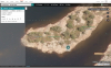
To be perfectly honest with you, I cannot tell how close the trees are in real life by looking at the poor imagery available in Google maps. Do you have a GPS receiver? If so, perhaps you could go to the location where the log says the Phantom crashed and take a photo at that spot (showing the coordinates on the GPS receiver).Others have suggested the tree scenario but after viewing the CSV logs they have also said that they agree it flew directly into the rocks. Looking at the location of the trees, any reasonable person would realize that flying at the trajectory outlined in the logs, hitting those trees, which are probably 40' from the shoreline, the drone would have fallen directly down and would have crashed on land, not in the water.
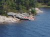
") The picture that was posted above the boat appears to show the Phantom well above the level of said rock. So I still think it had to lose quite a bit of altitude before hitting that rock but given where the photo was taken, both the GPS altitude and baro altitude say that the 12G deceleration (our assumed crash) occurred at the same altitude as the photo was taken (within 10 feet). It shows you were within about 10 feet of the same altitude for most of the last part of the flight. Given that photo, plus your trajectory and altitude, and assuming some "slop" in Google Maps/Earth, I assume DJI concluded that the only thing you could have possibly hit was a tree. I actually looked up Google Maps and Google Earth accuracy and found people reporting accuracy as good as 2.4m in some locations but also some studies that showed a 24m average variation. So whatever happened, my guess is that DJI considers positioning on the map as only a general indication of where you actually were. Keep in mind of course, that all of this is irrespective of what actually happened or what was observed because I assume DJI can only go by what the log shows.
The picture that was posted above the boat appears to show the Phantom well above the level of said rock. So I still think it had to lose quite a bit of altitude before hitting that rock but given where the photo was taken, both the GPS altitude and baro altitude say that the 12G deceleration (our assumed crash) occurred at the same altitude as the photo was taken (within 10 feet). It shows you were within about 10 feet of the same altitude for most of the last part of the flight. Given that photo, plus your trajectory and altitude, and assuming some "slop" in Google Maps/Earth, I assume DJI concluded that the only thing you could have possibly hit was a tree. I actually looked up Google Maps and Google Earth accuracy and found people reporting accuracy as good as 2.4m in some locations but also some studies that showed a 24m average variation. So whatever happened, my guess is that DJI considers positioning on the map as only a general indication of where you actually were. Keep in mind of course, that all of this is irrespective of what actually happened or what was observed because I assume DJI can only go by what the log shows.


