No Phoenix you have to use a DJI battery along with the externals! You turn the DJI battery on, then you have two XT 60 connectors sticking out of each side of the aircraft, which you plug in external into each of them after you turn the main battery on. When you turn the app on and run the aircraft, minutes will show up on the up higher than you're used to seeing or in some cases if you got a really good external you'll see the minute show up until two or three minutes into the flight and then you know you're in for a good run
Yes, don't try to solder to that end
Where the brass plug is, I've ruined a couple plugs that way in my early days, it takes too much heat to solder to that big brass plug
took the drone back out this morning with the itelite antenna 3200ft. so I tried a different setup with a panel on the controller side and a blade type antenna on the wifi. got 2300ft. So I then used the stock setup with a wind surfer on the controller antenna and got 6690ft.
I have not pulled out the big antenna's yet trying to get a good base to judge from.
Now to add the 6690 was done with the stock antenna's / winder surfer at 88 ft. I did raise up to 97 ft. didn't help and I had a Geico Insurance banner flying around at about 250 ft. new drone
I took the P2V+ out to the forest (will that is what the Government calls it). Hills working it to mountains. was going to go shooting but this bang it because forest fires. So I pulled out the P2V+ do some video work. The national forestry service was out doing some controlled burns all the road. I'll have the video up in a little while. But after video them I went on a little trip though the hills. Lost the signal at 7500ft. I lost line of sight because of the hills. I thought that was pretty good still using the stock antenna's with wind surfer on the controller. I was using DJI's App for the P2 so I don't have any data file to show.
I tried the dipole antennas at a little angle for the wifi and it made it worse. So I had then straight down and got this. I never lost video till the end and I new what happen after wards. From launch spot it was 234 ft up. But I was going over a large hill. I did raise it up a little. The cactus was looking pretty close.
Here is a picture I came up with from Google map. the point at the right is my starting point and the one to the left is where I ended up turning around. As you can see I was not at a higher starting point. I was about 200 ft lower.
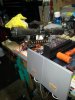
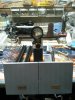
here is some pictures of the setup. I read some where that the antenna's should be moving around in the landing gear. So I got some small pieces of foam. That is the lime color in the one picture. Did it help I'm not sure but something is.
You wuss! It was almost 100 here saturday w/ 99% humidity, i squeezed in a couple flights[emoji41]
Had to makeshift some shade thoughView attachment 57061
This site uses cookies to help personalise content, tailor your experience and to keep you logged in if you register.
By continuing to use this site, you are consenting to our use of cookies.