Has anyone used the Ipad datalink with a PC?

Joined
May 14, 2014
Messages
203
Reaction score
20
Age
31
Location
Devon
Hi guys, I'm looking to put a datalink for use with way points onto my F550, but I don't want to shell out for an Ipad. I have a laptop and upon reading the manuals for the Dji data link on their website it seems like it should work, but I have contacted a seller online and they have said that the pc software has been discontinued...? Is this true? Is the only way for me to get way points on my F550 going to be buy an Ipad along with the datalink?

Any help at all would be massively appreciated as I had hoped to get my PFAW and use this platform for 3D photogrammetry for a surveying firm.
 
Don't currently know of any of the software functioning with the Windows Platform. They presently work with the IOS and android systems.
 

Attachments

  • Untitled.png
    Untitled.png
    103.9 KB · Views: 413
I have the iPad & PC version of GS. As of December 12th the map system used (Google) ended their support so no more maps on the PC version. That is the issue. The iPad version uses Apple Maps. DJI tends to build for iOS devices vs. Android.
 
I have the iPad & PC version of GS. As of December 12th the map system used (Google) ended their support so no more maps on the PC version. That is the issue. The iPad version uses Apple Maps. DJI tends to build for iOS devices vs. Android.

Thanks for the response, I had seen that the PC only version had been discontinued but wasn't aware of them doing it to this one too. So is the only way for me to get way pointing working on my F550 going to be buying an Ipad...?
 
If you need the BT then yes, iPad only. Buy a used one to save a few bucks. Apple also sells refurbished models on the web site. I use an iPad Mini 2.
Don't feel to bad, I only use Apple products so I had bought a Windows tablet to use GS with and less than a year later it is of no use to me. :(
 
If you need the BT then yes, iPad only. Buy a used one to save a few bucks. Apple also sells refurbished models on the web site. I use an iPad Mini 2.
Don't feel to bad, I only use Apple products so I had bought a Windows tablet to use GS with and less than a year later it is of no use to me. :(

I don't need the bluetooth functionality... Just waypointing. I don't suppose that changes anything? But of a pain yea... just added an extra £300 to what I needed to pick up :( :(
 
You use BT to connect to the bird no?

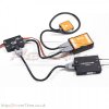
From what Im aware you get a big black box with a big antenna which you plug the BT into if you are using it. Thats for your Ipad to tell the data link what to do. The bit you put on the UAV is a smaller black box with a diversity antenna on it... (see pic) I thought you could use the box with the big antenna in a laptop wired like the pic in the reply to RoyVa
 

Attachments

  • DJI-IOS-Ground-Station-and-Data-Link-Naza-M-700x700.jpg
    DJI-IOS-Ground-Station-and-Data-Link-Naza-M-700x700.jpg
    63 KB · Views: 1,732
Just seen on the DJI website that they have indeed removed PC functionality from the Ipad datalink aswell, what a pain.... looks like im going to have to sell my soul to the ghost of steve jobs after all... :-(
 
From what Im aware you get a big black box with a big antenna which you plug the BT into if you are using it. Thats for your Ipad to tell the data link what to do. The bit you put on the UAV is a smaller black box with a diversity antenna on it... (see pic) I thought you could use the box with the big antenna in a laptop wired like the pic in the reply to RoyVa
Right, I have that setup in my P2 Zen. I took off the case on the bird end to save weight.
 
I have the iPad & PC version of GS. As of December 12th the map system used (Google) ended their support so no more maps on the PC version. That is the issue. The iPad version uses Apple Maps. DJI tends to build for iOS devices vs. Android.
Greetings! At present I have been familiarizing myself with the pc ground station doing simulation runs. I have a phantom 2 non vision. The pc ground station runs like a normal program I think so I'm confused with the google ending GE support making the program "useless". Does this mean if I upload waypoints generated through the photogrammetry tool and hit GO my phantom will not fly or something bad will happen? One more thing the GE maps do shows up ok when it's supposed not to show up anymore? Please do share thoughts thanks.
 

Recent Posts

Members online

No members online now.

Forum statistics

Threads
143,094
Messages
1,467,591
Members
104,979
Latest member
jrl