Flytrex log exported to Google Earth for 3D view of flight.

Joined
Jun 7, 2014
Messages
65
Reaction score
2
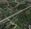
With Flytrex Core2 installed on your drone, you can upload missions to Flytrex.com and from there export a KML file to be opened in Google Earth which will let you see you flight in a simulated 3D view where you can spin around and see your flight from different angles.

Pretty cool and could be useful or many purposes.

See the flight in 3D here:
https://vimeo.com/104394881

Happy flying.
 
Re: Flytrex log exported to Google Earth for 3D view of flig

Very cool but on mine I can't get rid of the push pin on the pathway.
 
Re: Flytrex log exported to Google Earth for 3D view of flig

That stupid push pin thing just started recently for me.
 
Re: Flytrex log exported to Google Earth for 3D view of flig

You can click the pin on top right of properties and drop scale small. Its looks fine but shadow and aircraft path are same color. I thought I changed a setting. Maybe flytrex export changed. I need to check an old export.
 
Re: Flytrex log exported to Google Earth for 3D view of flig

Update-

It appears on 8-28 all my missions from flytrex have push pins because they have an time slider animation. Notice the bar at the top.

Trying to figure it out better. Changing slide changes different missions if you have more than one in view
 
Re: Flytrex log exported to Google Earth for 3D view of flig

For the most part you can drag the slides on the time bar at the top to one side and loose the pins or all but a couple.

Still working on it :)
 
Re: Flytrex log exported to Google Earth for 3D view of flig

LuvmyTJ play with the sliders here.

The bad part is the pins that animate if you "play" are the ground shadow and not the flight path.
 

Attachments

  • slider.jpg
    slider.jpg
    443.4 KB · Views: 496
Re: Flytrex log exported to Google Earth for 3D view of flig

OK I am out. LOL

Here is what I know. When Flytrex is exporting the KML file from their site now the are including placemark data.

In your KML code it looks like this.

<Placemark>
<TimeStamp>
<when>2014-09-07T11:52:04Z</when>
</TimeStamp>
<Point>
<coordinates>-93.682503,41.703509,-0 </coordinates>
</Point>
</Placemark>

If you manually select all the placements in the KML you can delete that last section of placemarks which falls between the last placemark tags <placemark></placemark>

OR

You can expand your mission in Google Earth and uncheck the box with green arrow which will uncheck everything below it. Then recheck the Mission [TRACK] and Mission [SHADOW].

This will show the flight path (track) as well as the shadow without all the stupid placemarks.

Seems there should be an option not to show placemarks however I have not found it.
 

Attachments

  • placemarks.jpg
    placemarks.jpg
    34.9 KB · Views: 509
Re: Flytrex log exported to Google Earth for 3D view of flig

rrmccabe said:
LuvmyTJ play with the sliders here.

The bad part is the pins that animate if you "play" are the ground shadow and not the flight path.

Thanks guys for the report about this! We will get this fixed in the next 48 hours and I'll post an update as soon as we get this fixed. :)
 
Re: Flytrex log exported to Google Earth for 3D view of flig

amitregev said:
rrmccabe said:
LuvmyTJ play with the sliders here.

The bad part is the pins that animate if you "play" are the ground shadow and not the flight path.

Thanks guys for the report about this! We will get this fixed in the next 48 hours and I'll post an update as soon as we get this fixed. :)

Thank you! I sent you a PM a few days ago I see is still in my out box. Please view it when you get time. Thank you.
 

Members online

No members online now.

Forum statistics

Threads
143,055
Messages
1,467,298
Members
104,920
Latest member
stovebayen