DroneDeploy Real World Applications

Joined
Jan 20, 2015
Messages
9
Reaction score
9
Age
73
Location
Minneapolis, MN USA
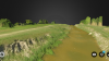
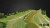
DroneDeploy is fascinating. It's ease of use with the Phantom 3, along with their cloud processing for 2D aerial mosaics and 3D interactive models, is amazing. Currently, my test demo exhibited some stitching errors and a prospective client thought the 3D version lacked detail in areas.

Is anyone here using DroneDeploy commercially?

Which applications is it good enough for actual professional use?

Are there better options for this kind of aerial imaging?

Thank You.
 
I'm going to give it w whirl. Hope more people try it out and post back here.
 
I would love to download the beta app but it is not available on IOS yet. Do you know when it will be available?

Uses - I am using it for landscape analysis as a landscape architect. Clients would love 3D models of their site before and after design/build.
 
Yeah, iOS beta would be great. It was out there at one time. I downloaded it but deleted it a while back bc I couldn't get it to connect.
 
I downloaded the beta app, downloaded their FW to my P3A. Made a 5 acre map of a bayou comprised of 82 images taken at 120 feet. A little bumpy to learn at first. I had a glitch that wouldn't allow me to take off because it couldn't take a test photo. Works 1 out of 5 times when it does, it's impressive. Flew the waypoints very accurately and landed 8 feet from takeoff. I was blown away by the 3d model being that it was my first.
 
If anyone knows of 3D apps or software. Or stereopair sort of technology please let me know. Thanks DroneRookie


Attachments

  • Screenshot_2015-10-03-20-22-49.png
    Screenshot_2015-10-03-20-22-49.png
    3.2 MB · Views: 1,358
  • Screenshot_2015-10-03-20-22-39.png
    Screenshot_2015-10-03-20-22-39.png
    3 MB · Views: 1,378
  • Like
Reactions: BigAl07
I'm testing all sorts of apps and software for using our Phantom 3 for mapping. I've not gotten Dronedeploy to work yet. Messing with it today. Litchi is pretty good, but you have to manually set waypoints. I've not tried the Pix4D beta app with my P3 yet either. As far as I can tell, they are still in beta.
As far as photo processing software, I tried the same 200+ photo 3 acre test area with Pix4D, Photomodeler Scanner, and Agisoft's PhotoScan. The best results by far was Agisoft's PhotoScan. It used the most photos and created the 'fullest' point cloud. Pix4D came in at a close second. Agisoft's PhotoScan is the mid priced one at $3,500 while Pix4D allows rentals at $350 per month. I'm currently looking for a good mission planner app to fly the mission with 60 to 80 % overlap on the photos. The phantom 3 is new enough that developers are still working on their apps. I think ultimately I will use Pix4D or Litchi (if they improve automated waypoints) to fly the mission and the Agisoft PhotoScan to process the images. I'd still like to try Dronedeploy though, but just can't get it to work yet.
 
Just used Drone deploy successfully for the first time. Impressed with flight plan and actual flight. It was screaming around at 14 mph 200' overhead. A bit fast, I thought, and I fear the stops and turns a bit quick and potentially stressful to the P3. I would prefer the drone NOT turn but just fly the pattern back and forth always facing the same way. Dronedeploy turns the drone so its always facing the next waypoint.
I opted for manual download and I'm currently processing the photos (only 28 of them) in Pix4D. I'm also uploading to DroneDeploy for processing.
[ 10 minutes later ]
Final results were lousy in Pix4D. Attributed mainly to lack of overlap. I ended up with only a partial map with several photos not even used. When I try again, I'll choose the 'high overlap' option in DroneDeploy.

Keep us posted on how that goes. I appreciate your testing and sharing. Being an iOS user, my hands are a bit tied. Which stinks and makes me miss my P2/Ground Station combo. I know a good map planning software will come soon but we may have the next Phantom before whatever it is gets out of beta.
 
The results I got back from DroneDeploy were better than the Pix4d, yet not as good as what I've gotten from flying manually and processing through the various softwares. I still think slowing the flight down and getting more overlap is key. I've found the DroneDeploy web site to be a bit confusing but I've only done this one thing on it so far. I'm sure it will get easier with more experimentation.
Right now I have billable work to do at work and Halloween to prepare for at home so I can't experiment as much as I'd like to!

Thanks for sharing!!! I'm going to mess around with the info you have presented next week. Best of luck with the work!!

Paul
 
I just got done testing pix4d and am very impressed. I had to manually fly a grid since I'm on iOS but the results were amazing. Keep updating us on your experiences.
 
Hello guys,

I just signed up so I can post here. I am part of a Land Surveying company and I have been testing the P3P with pix4d and dronedeploy for our purposes. I tried AGI Photoscan but it does not suit our particular needs.

With drone deploy I run it at 100 ft with 80% front lap and 50% side lap with targets on the ground that we shoot with out GPS for coordinate and elevation control.

I grab all the pictures and the control points we have and throw them into pix4d . Pix4d has been amazing to work with (especially with autocad).

This combination is what we are going to stick with as it has yield the best results for our workflow.

The pix4d app has been a bit of a pain to work with since you need to have your P3P hovering before it can sync. The switching back and forth from the Dji go app is annoying.
 
P.S. Having the battery mod over from Paul at fpvcustoms.com has help alot because with the extra time, we are able to overlap more and/or increase our area of collection. Just today a project that took 2 batterys to do was completed with just 1 set and 40% left after drone deploy stated it will take 19min to complete the project.
 
  • Like
Reactions: BigAl07
artsosa thanks for the update. I may give this another try soon.
 

Recent Posts

Members online

No members online now.

Forum statistics

Threads
143,094
Messages
1,467,586
Members
104,977
Latest member
wkflysaphan4