- Joined
- Jul 2, 2014
- Messages
- 26
- Reaction score
- 0
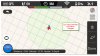
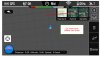
I am a pretty new flyer, but I have flown a couple of automated flights with my Phantom 2 Vision+, but that was a couple of months ago. Using the DJI Vision app on my iPhone, and swiping left to the ground station view, I see the Phantom icon, but the map is not beneath it. It is just a grid. Pinching in or out doesn't do anything to bring the details of a map in view. When I switch to the hybrid view the background is gray.
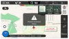
If I turn off the Phantom, I get the Phantom connection signal is lost message, but not the standard or hybrid map is visible. This has happened some time in the last couple of months. All me firmware and software appears to be up to date.
I have attached a couple of figures.
I am a pretty new flyer, but I have flown a couple of automated flights with my Phantom 2 Vision+, but that was a couple of months ago. Using the DJI Vision app on my iPhone, and swiping left to the ground station view, I see the Phantom icon, but the map is not beneath it. It is just a grid. Pinching in or out doesn't do anything to bring the details of a map in view. When I switch to the hybrid view the background is gray.
If I turn off the Phantom, I get the Phantom connection signal is lost message, but not the standard or hybrid map is visible. This has happened some time in the last couple of months. All me firmware and software appears to be up to date.
I have attached a couple of figures.
If I turn off the Phantom, I get the Phantom connection signal is lost message, but not the standard or hybrid map is visible. This has happened some time in the last couple of months. All me firmware and software appears to be up to date.
I have attached a couple of figures.
I am a pretty new flyer, but I have flown a couple of automated flights with my Phantom 2 Vision+, but that was a couple of months ago. Using the DJI Vision app on my iPhone, and swiping left to the ground station view, I see the Phantom icon, but the map is not beneath it. It is just a grid. Pinching in or out doesn't do anything to bring the details of a map in view. When I switch to the hybrid view the background is gray.
If I turn off the Phantom, I get the Phantom connection signal is lost message, but not the standard or hybrid map is visible. This has happened some time in the last couple of months. All me firmware and software appears to be up to date.
I have attached a couple of figures.