Class E question, getting prepared for part 107 certification

Joined
May 10, 2014
Messages
390
Reaction score
77
Location
Weston, Florida
Team,
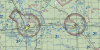
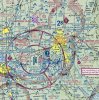
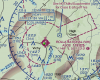
I am studying for knowledge test. I am not a pilot. Hope you can clarify this about class E and G airspace. If you look at Barnes County airport ( BAC), what is the floor of Class E inside and outside the magenta circle, is it 700 feet AGL, or 1,200 AGL...why..how you know? I cant differentiate it based on charts legends. I think this is important for UAS remote pilots as we can fly in class G, and the floor of class E will be our class G ceiling.

upload_2016-8-22_10-52-14.png
 

Attachments

  • upload_2016-8-22_10-51-35.png
    upload_2016-8-22_10-51-35.png
    928.9 KB · Views: 560
Magenta means that the floor starts at 700 AGL. Blue is for 1200 AGL. in either case, the floor is above our 'max' altitude. as an additional note: if there are dashed magenta lines around the airport, Class E starts at the surface under certain conditions. You have to check the NOTAMS or contact the appropriate FSS to find out what they are.
 
so, you mean inside the magenta circle is 700, outside is 1200...that is not clear with these legends...you are right when dashed, floor is sfc. But outside of E, it is not clear what is the height.

upload_2016-8-22_11-11-4.png
 
No, look at the images you posted. - inside the magenta, the floor is 700 AGL, outside, you are in class G. Inside the blue, floor is 1200 AGL, outside you are in class G.
 
This is all true.

However...
...IIRC, sUAS pilots operating under 107 will require ATC notification (in writing) while operating AT ANY altitude in Class E airspace as indicated by the outlines discussed here.

Also, Class E does not always coincide with an airport.
 
  • Like
Reactions: jofus
yes, but we are at G up to where E starts, which can be 700 or 1,200...don't know how to tell based on sectional chart.
Again, A magenta circle means that the floor is 700 ft AGL and a blue one indicates 1200 AGL. Simple and straightforward.
 
  • Like
Reactions: Falcon900
This is all true.

However...
...IIRC, sUAS pilots operating under 107 will require ATC notification (in writing) while operating AT ANY altitude in Class E airspace as indicated by the outlines discussed here.

Also, Class E does not always coincide with an airport.
N017RW is correct. No entry into the lateral boundaries of Class E airspace without prior approval. Class E is usually used to protect the instrument approaches to airports instrument approach procedures (IAP) but with no tower or space around airways (although those are usually too high to concern drone operators . In my hometown, the Class E (sfc) space is a corridor to the NE of the airport outside the normal 5 nm radius.
 
A couple of clarifications. Dashed magenta >always< indicates Class E starting at the surface. In the absence of other symbology, Class E starts at its default of 1200 AGL. Also you may operate in Class E without authorization (if you were on or adjacent to a tower, for example) unless the Class E is designated for an airport.
 
  • Like
Reactions: Falcon900
A couple of clarifications. Dashed magenta >always< indicates Class E starting at the surface. In the absence of other symbology, Class E starts at its default of 1200 AGL. Also you may operate in Class E without authorization (if you were on or adjacent to a tower, for example) unless the Class E is designated for an airport.

Nailed it.

I have a related question. I've pulled up the sectional chart on my city, and now I'm confused. I've flown around in the city limits outside of the Redstone Arsenal Class D airspace, and sometimes underneath the outer shelf of the Huntsville Class C, but it looks like RSA has a Class E extension that envelopes the entire city! And on closer look, Huntsville Intl appears to have class E surrounding the inner cylinder of the Class C space, underneath the shelf.

No other tool I have used says anything about this being class E airspace, including B4Ufly, Hover, DJI Go, or AirMap. What gives? Looks like every little dinky airport out here has Class E airspace, and that means I'd have to get ATC authorization to fly anywhere other than the middle of nowhere?

capture-jpg.63181

capture2-jpg.63183

capture3-jpg.63185
 

Attachments

  • Capture.JPG
    Capture.JPG
    258.5 KB · Views: 1,578
  • Capture2.JPG
    Capture2.JPG
    140.4 KB · Views: 1,430
  • Capture3.jpg
    Capture3.jpg
    150.4 KB · Views: 1,278
Last edited:
little dinky airport out here has Class E airspace
well, if I have learned about airspaces, the key here is the altitude. This airport is D up to 2,400 feet, then, it becomes class C up to 4,600. Then, it becomes E up to 18,000. Pls, is there a pilot around, can u reconfirm?
 
Those class e airspaces such as around Huntsville Exec start at 700' AGL. So if you are flying below 400 ', no notice required. Note that if you are hobby flying, you would still need to notify them if you are flying within 5 miles.
 
  • Like
Reactions: Falcon900
So, that's the difference in us getting our licenses in this case. If hobby, we need to notify, if we have license and flying below 400 feet and within 5 miles no notice required?
 
Those class e airspaces such as around Huntsville Exec start at 700' AGL. So if you are flying below 400 ', no notice required. Note that if you are hobby flying, you would still need to notify them if you are flying within 5 miles.

Part 107 states that you must have ATC authorization to operate within the lateral limits of Class E airspace that is designated for an airport. That seems to me that altitude is irrelevant in this case. Apparently I'm cool to fly outside the 5 mile radius of Redstone for fun, but as soon as I want to make a buck I have to get ATC authorization within a much larger radius... Doesn't make sense to me
 
Last edited:
Part 107 states that you must have ATC authorization to operate within the lateral limits of Class E airspace that is designated for an airport. That seems to me that altitude is irrelevant in this case. Apparently I'm cool to fly outside the 5 mile radius of Redstone for fun, but as soon as I want to make a buck I have to get ATC authorization within a much larger radius... Doesn't make sense to me

I think I can help clarify this issue. Important distinction to note here is that 107.41 talks about the lateral boundaries of the "SURFACE" area of class E. That is the dashed magenta lines around the airport not the fuzzy magenta circle area. The dashed lined areas show where Class-E goes all the way to the ground. The fuzzy magenta circles show where Class-E floor is at 700 feet above ground, well above our 400' limit. I've attached an image to show the two different areas.

Does that help?
 

Attachments

  • Screen Shot 2016-08-26 at 9.47.41 AM.png
    Screen Shot 2016-08-26 at 9.47.41 AM.png
    615.8 KB · Views: 619
I think I can help clarify this issue. Important distinction to note here is that 107.41 talks about the lateral boundaries of the "SURFACE" area of class E. That is the dashed magenta lines around the airport not the fuzzy magenta circle area. The dashed lined areas show where Class-E goes all the way to the ground. The fuzzy magenta circles show where Class-E floor is at 700 feet above ground, well above our 400' limit. I've attached an image to show the two different areas.

Does that help?

Ahhh I was thinking that the surface area was in reference to the shape of the airspace, not the area of Class E that starts at the surface of the Earth.
 
  • Like
Reactions: Unmannedsky
I think I can help clarify this issue. Important distinction to note here is that 107.41 talks about the lateral boundaries of the "SURFACE" area of class E. That is the dashed magenta lines around the airport not the fuzzy magenta circle area. The dashed lined areas show where Class-E goes all the way to the ground. The fuzzy magenta circles show where Class-E floor is at 700 feet above ground, well above our 400' limit. I've attached an image to show the two different areas.

Does that help?
I agree, that's the way I read the ref too.
 
  • Like
Reactions: Unmannedsky
I agree, that's the way I read the ref too.
Good catch, unmannedsky. It does specify the surface area of Class E.

Thanks! I think many will be surprised at the nuanced manner of question phrasing and legal-speak in the FAA testing/reg world. Everybody read closely! I can't tell you how many questions I knew the answer to but got wrong because I rushed through the reading... :confused:
 
I think I can help clarify this issue. Important distinction to note here is that 107.41 talks about the lateral boundaries of the "SURFACE" area of class E. That is the dashed magenta lines around the airport not the fuzzy magenta circle area. The dashed lined areas show where Class-E goes all the way to the ground. The fuzzy magenta circles show where Class-E floor is at 700 feet above ground, well above our 400' limit. I've attached an image to show the two different areas.

Does that help?

Unmannedsky,

That is how it makes sense in my brain.. but.. why are the apps (hover, B4UFLY) requesting I contact/submit notification where I am located? I am under a class C outer ring and within 5 miles of a class E fuzzy magenta. So technically I am under the 1700 class C and the 700 class E. It would make sense to only have to contact if I was going to operate in the 700' and up range (I never would) but why would I need to contact if staying under 400' in the class E 700 ring. Has anything changed recently that states any flight ops within 5 miles of any airport with a tower require contact even if under the 700' E floor? The coordinates for reference on where I would like to fly:

32°26'46.2"N 90°09'08.1"W
 

Recent Posts

Members online

No members online now.

Forum statistics

Threads
143,086
Messages
1,467,528
Members
104,965
Latest member
Fimaj