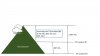
I was wondering how you all interpret AGL. While it sounds simple enough, if you are flying in the proximity of hills/mountains does the point of measurement change based on where the aircraft is and where "ground" is? I have attached a visual aid because "I am not a smart man, Jenny." (Forrest Gump reference).
Just wondering if you assure a gradual ascent and decent on the hill, could you theoretically climb well above 400' from original T/O point and still meet the intent of the FAA's 400' suggestion?
What do you think?
Just wondering if you assure a gradual ascent and decent on the hill, could you theoretically climb well above 400' from original T/O point and still meet the intent of the FAA's 400' suggestion?
What do you think?