
Just curious here...I took some of the best photos I've ever taken this past weekend. While I felt I was well outside of 3 miles to the local airport (and my P2 let me go up) I had several folks make the comment "hope this wasn't with a drone" or "I hope you know you were within a no-fly zone". I simply wouldn't have flown had I known that but I'm still not clear on what the official rule is for where you can and can't fly....I've seen multiple maps and heard folks say 3 miles and some folks say 5 miles. What say you?


You are using an out of date browser. It may not display this or other websites correctly.
You should upgrade or use an alternative browser.
You should upgrade or use an alternative browser.
Any run-ins with the FAA? Outcome?
- Thread starter creativedogmedia
- Start date
FAA says that within 5 miles of an airport a hobbyist/recreational flyer should contact the airport. They do not say it is a "no-fly" zone, just that contact/notification is required.
FAA goes on to say that commercial flying is not authorized at all except under Section 333 permits or a COA.
So that's what the FAA says. For whatever that is worth.
FAA goes on to say that commercial flying is not authorized at all except under Section 333 permits or a COA.
So that's what the FAA says. For whatever that is worth.
SilentAV8R said:FAA says that within 5 miles of an airport a hobbyist/recreational flyer should contact the airport. They do not say it is a "no-fly" zone, just that contact/notification is required.
FAA goes on to say that commercial flying is not authorized at all except under Section 333 permits or a COA.
So that's what the FAA says. For whatever that is worth.
Ok, very interesting....the last comment I wrote above was actually a post to a FB picture of mine by a local ATC for FAA (the city I shot used it). Just wasn't sure if I should reach out or follow the less is more mindset and not say a peep.
In the United States, the phrase "no-fly zone" has no legal meaning. What most people would consider a "no-fly zone" is called by the Federal Aviation Administration (FAA) a "Prohibited Area". Prohibited Areas are permanent and include places like the White House, Camp David, Area 51 and seven more around the country. Temporary Flight Restrictions are basically a "bubble" that follows the President and Vice President. The FAA calls them "VIP Movement" TFR's. There's also the political TFR's over Walt Disney World and Disneyland that serve no public need for safety, but Disney, Inc. doesn't like banner tows over their guests.
To extend on what Silent said - the FAA REQUESTS that you let ATC or the Airport Manager know if you are flying within 5 miles. There's no law or requirement. What will happen is the airport manager will ask how high and how long, then thank-you. During that period pilots arriving will be provided this information over the Automatic Terminal Information Service (ATIS). Something like "Caution, model aircraft activity 2-miles southeast at or below 400 ft". At a non-towered airport, the notification gets circular-filed because it takes a few hours for a NOTAM to be published, and by then you will be long gone.
OP - can we see the photo?
SteveMann said:In the United States, the phrase "no-fly zone" has no legal meaning. What most people would consider a "no-fly zone" is called by the Federal Aviation Administration (FAA) a "Prohibited Area". Prohibited Areas are permanent and include places like the White House, Camp David, Area 51 and seven more around the country. Temporary Flight Restrictions are basically a "bubble" that follows the President and Vice President. The FAA calls them "VIP Movement" TFR's. There's also the political TFR's over Walt Disney World and Disneyland that serve no public need for safety, but Disney, Inc. doesn't like banner tows over their guests.
To extend on what Silent said - the FAA REQUESTS that you let ATC or the Airport Manager know if you are flying within 5 miles. There's no law or requirement. What will happen is the airport manager will ask how high and how long, then thank-you. During that period pilots arriving will be provided this information over the Automatic Terminal Information Service (ATIS). Something like "Caution, model aircraft activity 2-miles southeast at or below 400 ft". At a non-towered airport, the notification gets circular-filed because it takes a few hours for a NOTAM to be published, and by then you will be long gone.
OP - can we see the photo?
Thanks for the information. I was given this link - https://www.mapbox.com/drone/no-fly/#5/42.196/-98.130 - which further confused me. I live just outside of Richmond, VA and the State Capital is NOT in a no-fly zone but Maggie L. Walker National Historic Site is (it's part of the National Park Service so that part does make sense). It's just strange that nothing (outside of this historic site and the RIC airport is off limits).
Here is the photo that brought this conversation to light (it's one of the best photos I have personally ever taken - if not my all time favorite). If you look at the link I provided (which I saw after I flew) the location of this photo is in Roanoke, VA below the "e" in Roanoke. I was under 400' for this shot.
Attachments

SteveMann said:To extend on what Silent said - the FAA REQUESTS that you let ATC or the Airport Manager know if you are flying within 5 miles. There's no law or requirement.
Sorry, that is incorrect. Section 336 (a) 5) of Public Law 112-95 REQUIRES that you notify an airport within 5 miles when you plan to operate. P.L. 112-95 became effective on February 14, 2012 when the President signed it into law. It defines how hobbyists are to operate. As I noted before, the FAA says that you cannot operate commercially except under some very restricted circumstances. That bit IS open to interpretation.
(5) when flown within 5 miles of an airport, the operator of the aircraft provides the airport operator and the airport air traffic control tower (when an air traffic facility is located at the airport) with prior notice of the operation (model aircraft operators flying from a permanent location within 5 miles of an airport should establish a mutually-agreed upon operating procedure with the airport operator and the airport air traffic control tower (when an air traffic facility is located at the airport)).
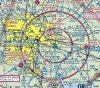
This is a great website to get aeronautical sectional charts to see what the airspace is:
http://skyvector.com/
RIC is Class C airspace and has a 5 nautical mile ring around it where that airspace extends to the ground. I would steer clear of that if it were me. Technically you can operate under 336 if you contact the ATC facility there, but that is busy airspace and I would tend to just avoid it.
Interesting enough, all the Section 333 permits the FAA has approved all require staying clear of Class B and C airspace all together.
Attachments
SilentAV8R said:This is a great website to get aeronautical sectional charts to see what the airspace is:
http://skyvector.com/
RIC is Class C airspace and has a 5 nautical mile ring around it where that airspace extends to the ground. I would steer clear of that if it were me. Technically you can operate under 336 if you contact the ATC facility there, but that is busy airspace and I would tend to just avoid it.
Interesting enough, all the Section 333 permits the FAA has approved all require staying clear of Class B and C airspace all together.
So, technically....I shouldnt be flying in downtown Richmond at all? The map you provided is the gospel of maps, right? Is there one for the layman that doesnt understand all of the aviation jargon? What is the point of the other map I provided? I see you are in Orange County....Is Huntington Beach in a no-fly zone?
ddublu said:So, technically....I shouldnt be flying in downtown Richmond at all? The map you provided is the gospel of maps, right? Is there one for the layman that doesnt understand all of the aviation jargon? What is the point of the other map I provided? I see you are in Orange County....Is Huntington Beach in a no-fly zone?
The map I posted is a part of the FAA Sectional Chart for that area. As far as the FAA goes, it is gospel since it spells out the airspace. If you plan on flying in that area it would not be a bad idea to understand it.
Here is the FAA document: https://www.faa.gov/air_traffic/flight_ ... 12thEd.pdf
https://www.faa.gov/air_traffic/flight_ ... ero_guide/
This is a good reference: http://cessnachick.com/525-2/
ANd once again, there is no such thing as a "no fly zone" except for Prohibited Areas designated by the FAA (like the WHite house, etc.). The "No Fly" zone that DJI uses has nothing to do with actual airspace requirements and definitions as used by the FAA. I would not rely on them to determine where to fly or not.
Huntington Beach is not is a "no fly zone" since none exists. But it is in a area where VFR traffic is funneled into John Wayne, where lots of people and traffic are and some other things you might want to consider before flying there.
SilentAV8R said:ddublu said:So, technically....I shouldnt be flying in downtown Richmond at all? The map you provided is the gospel of maps, right? Is there one for the layman that doesnt understand all of the aviation jargon? What is the point of the other map I provided? I see you are in Orange County....Is Huntington Beach in a no-fly zone?
The map I posted is a part of the FAA Sectional Chart for that area. As far as the FAA goes, it is gospel since it spells out the airspace. If you plan on flying in that area it would not be a bad idea to understand it.
Here is the FAA document: https://www.faa.gov/air_traffic/flight_ ... 12thEd.pdf
https://www.faa.gov/air_traffic/flight_ ... ero_guide/
This is a good reference: http://cessnachick.com/525-2/
ANd once again, there is no such thing as a "no fly zone" except for Prohibited Areas designated by the FAA (like the WHite house, etc.). The "No Fly" zone that DJI uses has nothing to do with actual airspace requirements and definitions as used by the FAA. I would not rely on them to determine where to fly or not.
Huntington Beach is not is a "no fly zone" since none exists. But it is in a area where VFR traffic is funneled into John Wayne, where lots of people and traffic are and some other things you might want to consider before flying there.
So where CAN you fly? Where do you fly?
- Joined
- Feb 19, 2014
- Messages
- 701
- Reaction score
- 23
Until the FAA, and congress, write down definitive and enforceable laws, you can fly practically anywhere you want not otherwise restricted by law.
National Parks are restricted now.
Just use some common sense when near an airport.
When you know you're gonna be near an airport, take a look at a map that shows the runways.
Draw lines out beyond the runways and stay clear of those lines.
Planes aren't gonna be veering to far off those lines during landing or take offs.
And I kind of think somebody's gonna get a little pissed off when a 747 flies 500 feet over downtown and there is no airport around.
I really still have no idea what really is meant by a "no fly zone".
If you have to fly around it, then why is there an airport?
Suwaneeguy said:Until the FAA, and congress, write down definitive and enforceable laws, you can fly practically anywhere you want not otherwise restricted by law.
The laws we are waiting on are the sUAS Rule for commercial flying. Congress already took care of models with Section 336, and it IS an enforceable laws, Congress authorized the FAA to take enforcement action as they deem fit.
National Parks are restricted now.
Which by the way is not written in any law, it is NPS policy.
If you look at a sectional map for your area, http://www.faa.gov/air_traffic/flight_info/aeronav/digital_products/vfr/ the only places I would fly with extra caution are the inner magenta circle. With extreme caution inside the blue circle around airports (the inner circles are 5 statute miles). There's also the prohibited areas marked with a blue hash border. Definitely don't fly there.ddublu said:So where CAN you fly? Where do you fly?
Section 336 (a) 5) of Public Law 112-95
The FAA is asserting that modelers must comply with Sec. 336 of the FMRA of 2012, which is a regulation that has not yet been adopted and is, therefore, not enforceable. The AMA and two other organizations have filed suit against the FAA over section 336.
From Dronelawjournal.com:
"Bearing in mind that the FMRA obliges only the FAA and not the general public, if the FAA is still developing regulations, as Congress ordered it to do under the FMRA, then by definition those regulations, including any based upon Sec. 336, don’t yet exist in any enforceable form. So the FAA claims authority ... upon a non-existent prospective regulation, which is not yet enforceable."
From Brendan Schulman (Pirker's lawyer):
"The 2012 statute instructed the FAA to create rules using the notice and comment rulemaking process, with public input, not to issue policy statements. By stating that this policy is 'effective immediately,' the FAA is once again trying to impose new rules without consulting with the public,"
While it is not required since enforcement of Section 336 is arguable, towers and airport managers do appreciate being notified of model flight within five miles of their facility.
SteveMann said:Section 336 (a) 5) of Public Law 112-95
The FAA is asserting that modelers must comply with Sec. 336 of the FMRA of 2012, which is a regulation that has not yet been adopted and is, therefore, not enforceable. The AMA and two other organizations have filed suit against the FAA over section 336.
Not exactly. The AMA actually understands that Section 336 became law on the day it was signed. So does the FAA. So do most others with the exception of a few like Peter Sachs.
What the FAA and the others are suing over is the over reach and intrusiveness in the FAA's interpretation of Section 336. AMA wants them to understand what it actually says and that the FAA went too far in their interpretation.
From Brendan Schulman (Pirker's lawyer):
"The 2012 statute instructed the FAA to create rules using the notice and comment rulemaking process, with public input, not to issue policy statements. By stating that this policy is 'effective immediately,' the FAA is once again trying to impose new rules without consulting with the public,"
As I understand what Brendan is saying based on reading some of his other writings and posts, along with some personal communications is that the FAA is overstepping the limits of the law and trying to circumvent the rule making process with their interpretation. He is AMA's attorney in this and I know for a fact that AMA does not dispute that Section 336 is current law. The dispute is over what the FAA is doing with that law.
In fact, I asked Rich Hanson, the AMA Government Affairs person, about this point. Here is his answer:
Hi Bill,
Although there are a lot of lawyers out there saying a lot of things, AMA’s understanding and position is that Sec 336 is law and was applicable the day the FAA Modernization and Reform Act of 2012 was signed. (If you have one lawyer in the room you have an opinion, if you have two lawyers in the room you have an argument.)
Operating “within the programming” means you have to meet the requirements for program participation established by the CBO. In AMA’s case that means you must be a member.
Hope you had a terrific Thanksgiving,
Rich Hanson
ddublu said:So where CAN you fly? Where do you fly?
My general rule is to stay clear of Class B or Class C airspace where it extends to the ground. Class C is generally a circle 5nm in radius around the main airport. Class B airspace is a bit more complicated, but again, where ever it extends to the ground, I just do not fly.
I also avoid Class D airspace if I can (5 NM around other towered airports). I just do not have to fly that bad to take a chance in these areas.
In other areas I pay attention to the FAA Sectional to see where higher concentrations of VFR traffic might be so I can be extra vigilant in those areas. The closer I am to busy airspace the lower I tend to fly. But even out in the sticks I rarely exceed 400 feet. I am always within solid VLOS, which for me means within about 800 to 1,000 feet laterally.
I fully embrace the concept that it is my job to avoid conflicts with full scale aircraft and that is my guiding principal.
Ok, I get the no fly zones, but there is conflicting information, at least to me. I take it the area around the airport depends on the size airport, large commercial airport compared to small recreational airports. In DJI program itself, it has the 2 different areas as far as area covered by size of airport. Central area of no fly at all, outer area of height restrictions as distance from airport increases. Should the DJI areas be ignored as far as the heights allowed to fly? Not meaning, hell with it fly there anyway, just don't fly there. And DJI isn't very accurate. I have a airport down the street from me, which does have small business and military jets fly into, so not just a grass field, that is not in the DJI program.
What is messing you up is thinking that the DJI "No Fly Zones" and other definitions around airports mean something. They do not.
The first issue with the DJI airport info is it misses a lot of airports, wrongly categorizes others, and is just a flawed implementation from the get go.
For instance, the only 2 airports in the LA/Orange County area are LAX and John Wayne/Orange county. Long Beach, Burbank, Van Nuys, Torrance, Whiteman, and several others are not in the DJI data base. So you could launch next to Van Nuys, one of the busiest GA/Biz jet airports in the country and based on the DJI database think you are good to go, which you are not!!
Again, I stay away from all CLass B, C, D airspace (any airport with a tower). I get no closer than 5 nautical miles in general, and if I am closer, I stay very low, like under 100 feet.
butch518 said:Ok, I get the no fly zones, but there is conflicting information, at least to me. I take it the area around the airport depends on the size airport, large commercial airport compared to small recreational airports. In DJI program itself, it has the 2 different areas as far as area covered by size of airport. Central area of no fly at all, outer area of height restrictions as distance from airport increases. Should the DJI areas be ignored as far as the heights allowed to fly? Not meaning, hell with it fly there anyway, just don't fly there. And DJI isn't very accurate. I have a airport down the street from me, which does have small business and military jets fly into, so not just a grass field, that is not in the DJI program.
There are hundreds of small airports that don't appear on the DJI No-Fly list, but the cautions still apply. I suspect that the DJI list is a proactive move initially targeting those airports with Class B airspace and some Class C airports. It makes them easier to get governments to accept them rather than ban them outright. I don't follow your question. If you download the FAA sectional charts for the area where you want to fly you can see where the Class B and Class C airport areas extend to the surface. I wouldn't recommend flight in those areas regardless if it is in the DJI no-fly database.butch518 said:Ok, I get the no fly zones, but there is conflicting information, at least to me. I take it the area around the airport depends on the size airport, large commercial airport compared to small recreational airports. In DJI program itself, it has the 2 different areas as far as area covered by size of airport. Central area of no fly at all, outer area of height restrictions as distance from airport increases. Should the DJI areas be ignored as far as the heights allowed to fly? Not meaning, hell with it fly there anyway, just don't fly there. And DJI isn't very accurate. I have a airport down the street from me, which does have small business and military jets fly into, so not just a grass field, that is not in the DJI program.
There is a handy App that can be helpful for staying out of airport space. RCFLYMAPS http://www.rcflymaps.com/ is available for IOS devices from the iPhone Store. It's a work in progress, but it displays a 5 mile red zone around most airports, with more being added (updates).
There is also an app for sectional maps.
Each of these apps is less than $5 and a good investment.
You can view sectional maps online (free) -http://skyvector.com/
You can buy a printed version of the sectional for your area from places like like Sportys.com for less than $10. Most sectionals are updated every six months.
With regard to the comment about "understanding Sectional Charts", if you're going to be flying anything anywhere, you need to know how to read sectional charts to stay out of trouble. It's not that hard. If you buy a printed version, the legend is printed right on it. Otherwise there are lots of resources online. You can start with this one : https://www.faa.gov/air_traffic/fli...aero_guide/media/Chart_Users_Guide_12thEd.pdf
Thanks for the information. I was given this link - Don't Fly Drones Here - which further confused me. I live just outside of Richmond, VA and the State Capital is NOT in a no-fly zone but Maggie L. Walker National Historic Site is (it's part of the National Park Service so that part does make sense). It's just strange that nothing (outside of this historic site and the RIC airport is off limits).
Here is the photo that brought this conversation to light (it's one of the best photos I have personally ever taken - if not my all time favorite). If you look at the link I provided (which I saw after I flew) the location of this photo is in Roanoke, VA below the "e" in Roanoke. I was under 400' for this shot.
I live in Roanoke. This is an amazing shot!
Similar threads
- Replies
- 1
- Views
- 2K
- Replies
- 16
- Views
- 3K


