2014 Aerial Images

Joined
Mar 30, 2014
Messages
173
Reaction score
9
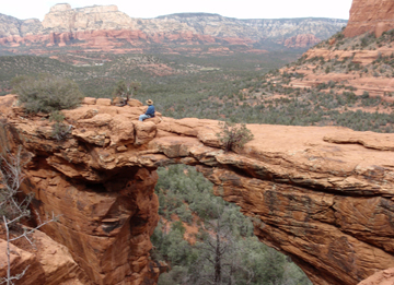
I had a blast over the last year flying and exploring cool places and capturing this imagery. This 5 minute video is a collection of my favorite in-flight clips taken in 2014.

I hope you enjoy the clips as much as I had fun taking them. Feel free to post comments.


Last edited:
Re: Aerial Imagery of 2014

Cool stuff. Where is that rock bridge that all the people were standing on? Looks like a nice place to see in person
 
Re: Aerial Imagery of 2014

knuckles said:
Cool stuff. Where is that rock bridge that all the people were standing on? Looks like a nice place to see in person
The natural bridge is located near Slade, Kentucky and within the Natural Bridge State Park. and Daniel Boone National Forest. The area features about 20 natural bridges. The 2014 video shows 3 bridges...Natural Bridge, Sky Bridge, and the Arch Bridge that spans the water. The most challenging shot was flying under the arch bridge that spans the water. I did not use GPS for that shot. Another scary shot was the flight where I am flying straight up through the trees to view Balanced Rock. It was my first trip to Kentucky and I was quite impressed with the scenery.

Here is a link to a video that focuses on features of Kentucky's Natural Bridge area.
Natural Bridge Area: http://youtu.be/HpMbng61DtU?list=PLQlCk ... f4CwDGF4Xr
 
Re: Aerial Imagery of 2014

that's cool. A lot of nice views for sure. I was wondering about what it would be like flying ATTI mode under a bridge. I haven't done it yet.

I might try to fly this rock bridge this week if I make it there. I'll be staying not far from it I just need to find a good hiking route.
DevilsBridge.jpg
 
Re: Aerial Imagery of 2014

knuckles said:
I was wondering about what it would be like flying ATTI mode under a bridge. I haven't done it yet.

My preference is flying in GPS mode when I know I can acquire and hold 7 or more satellites. I feel that GPS mode cuts down on unwanted drift very effectively. I was in a ravine with tree cover and with the bridge itself so getting a good GPS lock was not an option. Your location may be different. I know that if you do not have a good GPS signal lock, then the phantom can drift a bit.

-Zinnware
 
Re: Aerial Imagery of 2014

Mholz said:
Nice work!!
Thanks for the feedback. I would not have imagined last March how much fun I would have had flying in the places that I did. It is always a big rush trying to get the shot with all of the challenges encountered.
 
Re: Aerial Imagery for 2014

I added some clip descriptions and geo location coordinates in the initial post.
 
Re: Aerial Imagery for 2014

RedRyderMedia said:
You had a fun 2014! Congrats on a great reel and living a great life!
Thanks RedRyder for the compliment. Every time I fly in new places gives me a real adrenalin rush. Sometimes I catch my knees shaking.
 
Re: Aerial Imagery for 2014

Nice! Some scary shots in there, especially in the woods.

I'm almost at a full year now. Been going through and taking clips from all my flights, for a compilation vid.
 
Re: Aerial Imagery for 2014

poostik said:
Nice! Some scary shots in there, especially in the woods.
Yes, you are right about the two most scary flights:
1:26 Rock Bridge Arch
1:18 Balanced Rock.

Both flights for the shots I kept real short. At Balanced rock, I had rock face bluff right behind me that rose a few hundred feet. I debated to fly with GPS at that location but was surprised when I picked up more than 6 satellites and held them. I decided to fly there with GPS mode and the Phantom 2 flew perfectly in the tight space between trees. I was still worried as with past experience the Phantom can drift quite a bit with poor satellite reception. It was a big adrenalin rush. As a took off, my wife Carol noticed and warned me about the hiker coming up the trail. My preference was not to have people near by for safety and less distractions, but I believe that they added interest and scale to the shot.
 
Re: Aerial Imagery for 2014

I have a few fly-unders/throughs over the course of many videos. It's been scary as hell. I have a few shots that I still haven't done, due to not having the balls. One is a very tight waterfall shot and another is over a dam on a lake with very low tree cover. It's funny . . . people see some of my vids and tell me how crazy/cool a shot is. The shot is less than 5 seconds and may have taken an entire battery to get. lol

I've been planning to put together some kind of 250 and really get into the FPV racing thing. I think it'll boost my pilot skills as well as give me the cajones to get the shots I haven't yet.
 
Re: Aerial Imagery for 2014

poostik said:
I'm almost at a full year now. Been going through and taking clips from all my flights, for a compilation vid.
I have enjoyed watching many of your videos and look forward to seeing your compilation.
 
Re: Aerial Videos for 2014

bpippin said:
Very nice! My favorite was the kites!

Strange ending... :)

Thanks. Many of my friends like the kite sequence too.

Happy Halloween!
 
Re: Aerial Videos for 2014

I added closed captions to the video to provide clip location descriptions.
 
Re: Aerial Videos for 2014

So many wonderful perspectives to name just a few... 00:35 the rainbow waterfall is priceless; the four surfers at 2:41; the resort at 4:10; flying past the steeple and flag at 4:23; and the Halloween footage at the very end. (Was the Halloween shot reversed?)

Very nice, thanks.
 

Recent Posts

Members online

Forum statistics

Threads
143,094
Messages
1,467,597
Members
104,980
Latest member
ozmtl