Recent content by FCEAgtech
-

NOTAMS for Ag Operations
Thanks. That is what I THOUGHT but was not sure. So submitting the UOA will place the notice on services like SkyVector.com, but does not create an official NOTAM. Am I correct? I hate to keep beating this horse, but I really am concerned with the best and most effective way to make aerial...- FCEAgtech
- Post #6
- Forum: Agriculture
-
NOTAMS for Ag Operations
So, does it actually create a NOTAM without a COA number?- FCEAgtech
- Post #4
- Forum: Agriculture
-
NOTAMS for Ag Operations
Okay, so with the advent of part 107 it is my understanding that we don't need, in most cases, to petition for a section 333 exemption. However, wouldn't it be prudent to file a NOTAM for Ag ops to notify aerial applicators of UAS ops? Does anyone know how to go about this? Nevermind... I...- FCEAgtech
- Thread
- Replies: 6
- Forum: Agriculture
-
Share Some NDVI!
Yep, but about 20 spray drones flying autonomously. Still less money than a ground rig sprayer!- FCEAgtech
- Post #9
- Forum: Agriculture
-
What Niche's Lend Themselves to Working With Smaller Companies?
Aerial imagery is really most useful as a PART of a complete precision farming effort. They have been shown a lot of pretty ndvi pictures from satellite imagery that they may have paid for in the past and been burned by the lack of ROI. Once we put our sUAS into the toolbox here, and focused...- FCEAgtech
- Post #20
- Forum: Agriculture
-
Share Some NDVI!
Sure! Hardware: P4P with a Sentera NDVI+ upgrade (including incident light sensor) Software: Sentera AgVault and AgLeader SMS Advanced- FCEAgtech
- Post #4
- Forum: Agriculture
-
Why NDVI camera when drone deploy can convert?
So you would see an issue in your NDVI imagery (which can be quicktiled and immediately available with a relatively less expensive alternative to drone deploy) and you could instantly zoom into the RGB image in the same software to triage the issue. It will take flights over a number of acres...- FCEAgtech
- Post #10
- Forum: Agriculture
-
Why NDVI camera when drone deploy can convert?
Please see my posts in "share some NDVI" True NDVI provides you with an actual scale upon which to work from. NDVI is computed from near infrared imagery, which is a part of the spectrum that your RGB camera does not process. You CAN have a notch filter installed on your RGB camera to capture...- FCEAgtech
- Post #9
- Forum: Agriculture
-
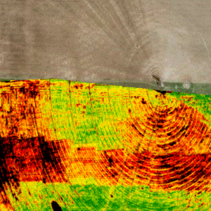
Share Some NDVI!
Here we have a processed NDVI analysis of a bean field on which a side by side test plot on corn was grown the year before. The west half shows pesticide carry over from the previous year (the green shows excessive weeds). Same platform as previous imagery, just processed through SMS.- FCEAgtech
- Post #2
- Forum: Agriculture
-
Share Some NDVI!
AlfHalf by FCEAgtech posted Nov 8, 2017 at 3:59 PMThought I would share some imagery that has proven that our platform paid for itself in spades. This imagery shows damage from sprayer tank contamination, which we were able to plug into AgVault to assess the exact number of acres damaged. Just...- FCEAgtech
- Thread
- Replies: 8
- Forum: Agriculture
-
-
What Niche's Lend Themselves to Working With Smaller Companies?
Our local JD dealer does not have an in house pilot. Retailers have in house precision ag techs (my job) and imagery is tied to all phases of precision ag -- VR fertilility and pest management, as well as hybrid placement - crop monitoring - damage assessment, etc. Nebraska panhandle. I...- FCEAgtech
- Post #17
- Forum: Agriculture
-
What Niche's Lend Themselves to Working With Smaller Companies?
For stitching, I'm using a Sentera NDVI+ and incident light sensor, flown at 300ft with 75% overlap and sidelap- FCEAgtech
- Post #15
- Forum: Agriculture
-
What Niche's Lend Themselves to Working With Smaller Companies?
So this is imagery captured by a Sentera single NDVI+ that we were able to quicktile and view right at the edge of the field. This is the raw image, prior to any stitching or alterations to the NDVI scale in SMS. Half this field received a timely fungicide application, half did not (corn)...- FCEAgtech
- Post #14
- Forum: Agriculture