Recent content by ExcObs1
-

RGB Camera
Drone deploy has a specific algorithm for RGB pictures. Think it's "vari" I've compared to IR pics and it's not bad at all.- ExcObs1
- Post #5
- Forum: Agriculture
-
Agriculture use
I have their single sensor and an Advanced. I do not use their software/application. It will do what they claim it will do.- ExcObs1
- Post #25
- Forum: Agriculture
-
What Niche's Lend Themselves to Working With Smaller Companies?
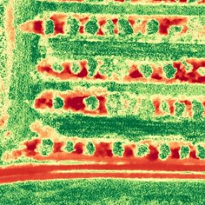
NIR imaging (NDVI) or even thermal may yield early clues. Stressed or diseased plant/leaves reflect less green and NIR light. Some of the family has orange groves which have been devastated by the greening disease. I've spent some time playing around w/NIR/NDVI at the grove. NDVI1 by ExcObs1...- ExcObs1
- Post #9
- Forum: Agriculture
-
What Niche's Lend Themselves to Working With Smaller Companies?
You are forward thinking and ahead of most "small" farmers. I've spent the last 30 years working for Verizon Communications (telephone/data service/fios) not wireless. When it comes to technology advances, you learn to grab on and let it pull you along or pick yourself up and look around for...- ExcObs1
- Post #7
- Forum: Agriculture
-
Legalize UAV/Drone flying in FL State Parks!
LOL..very good point :) Although I do side with the no fly in State parks crowd. There's over 1 million acres that's still flyable (today) in Florida's NF's. I own property in Apalachicola Forest, fly there a lot and have yet to see another UAS.- ExcObs1
- Post #31
- Forum: General Discussion
-
Litchi update
You can now stream vid to a second (wifi) device...I think- ExcObs1
- Post #2
- Forum: Control (Go, Litchi, etc..)
-
What Niche's Lend Themselves to Working With Smaller Companies?
I've found most local farming ops are joined at the hip with the area university/extension agency, many of which are woefully behind in this technology. But I guess you get what you pay for :)- ExcObs1
- Post #4
- Forum: Agriculture
-
Litchi Problem - shows disconnected but it is connected
I had the same scenario recently, have not updated to ios 10 on the ipad.- ExcObs1
- Post #6
- Forum: Phantom 3 Pro/Adv
-
DJI Mandatory, uninterruptible actions are wrong, legally actionable
Careful...there ARE a few sophisticated ones online here :)- ExcObs1
- Post #39
- Forum: General Discussion
-
-
results of first 107 flight
You could be providing a service that requires a Surveyor or Photogrammetrists licensing.....but again, I'm still not sure of the legal aspect of the work provided in example.- ExcObs1
- Post #6
- Forum: Rules and Regulations
-
results of first 107 flight
Photogrammetrists do. Just not sure what the caveat "For reference Only" would mean/provide for in this example.- ExcObs1
- Post #4
- Forum: Rules and Regulations
-
-
Temporary License
Test date 9/5 (PM) Test associated in IACRA 9/7 (AM) Completed application 9/7 (AM) TEMP received in IACRA console 9/13 (AM)- ExcObs1
- Post #57
- Forum: Rules and Regulations